

Mapping temperate old-growth forests in Central Europe using ALS and Sentinel-2A multispectral data
- PMID: 39183185
- PMCID: PMC11345331
- DOI: 10.1007/s10661-024-12993-5
Mapping temperate old-growth forests in Central Europe using ALS and Sentinel-2A multispectral data
Abstract
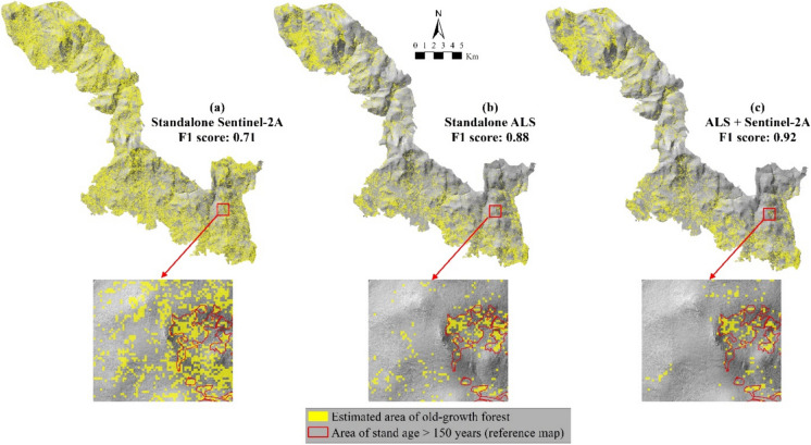
Old-growth forests are essential to preserve biodiversity and play an important role in sequestering carbon and mitigating climate change. However, their existence across Europe is vulnerable due to the scarcity of their distribution, logging, and environmental threats. Therefore, providing the current status of old-growth forests across Europe is essential to aiding informed conservation efforts and sustainable forest management. Remote sensing techniques have proven effective for mapping and monitoring forests over large areas. However, relying solely on remote sensing spectral or structural information cannot capture comprehensive horizontal and vertical structure complexity profiles associated with old-growth forest characteristics. To overcome this issue, we combined spectral information from Sentinel-2A multispectral imagery with 3D structural information from high-density point clouds of airborne laser scanning (ALS) imagery to map old-growth forests over an extended area. Four features from the ALS data and fifteen from Sentinel-2A comprising raw band (spectral reflectance), vegetation indices (VIs), and texture were selected to create three datasets used in the classification process using the random forest algorithm. The results demonstrated that combining ALS and Sentinel-2A features improved the classification performance and yielded the highest accuracy for old-growth class, with an F1-score of 92% and producer's and user's accuracies of 93% and 90%, respectively. The findings suggest that features from ALS and Sentinel-2A data sensitive to forest structure are essential for identifying old-growth forests. Integrating open-access satellite imageries, such as Sentinel-2A and ALS data, can benefit forest managers, stakeholders, and conservationists in monitoring old-growth forest preservation across a broader spatial extent.
Keywords: Airborne LiDAR; Data fusion; Forest structure; Multispectral; Stand age; Structural complexity.
© 2024. The Author(s).
Conflict of interest statement
The authors declare no competing interests.
Figures


References
-
- Atkins, J. W., Fahey, R. T., Hardiman, B. H., & Gough, C. M. (2018). Forest canopy structural complexity and light absorption relationships at the subcontinental scale. Journal of Geophysical Research: Biogeosciences,123, 1387–1405. 10.1002/2017JG004256 10.1002/2017JG004256 - DOI
-
- Ayrey, E., Hayes, D. J., Fraver, S., Kershaw, J. A., & Weiskittel, A. R. (2019). Ecologically-based metrics for assessing structure in developing area-based, enhanced forest inventories from LiDAR. Canadian Journal of Remote Sensing,45(1), 88–112. 10.1080/07038992.2019.1612738 10.1080/07038992.2019.1612738 - DOI
-
- Barredo, J. I., Brailescu, C., Teller, A., Sabatini, F. M., & Mauri, A. (2021). Mapping and assessment of primary and old-growth forests in Europe (Issue EUR 30661 EN). 10.2760/13239
-
- Breiman, L. (2001). Random forests. Machine Learning,45(1), 5–32. 10.1023/A:1010933404324 10.1023/A:1010933404324 - DOI
-
- Brunet, J., Fritz, Ö., & Richnau, G. (2010). Biodiversity in European beech forests – A review with recommendations for sustainable forest management. Ecological Bulletins,53, 77–94.
MeSH terms
Grants and funding
- 397.ID 834709, H2020-EU.1.1/European Research Council,European Union
- 397.ID 834709, H2020-EU.1.1/European Research Council,European Union
- 397.ID 834709, H2020-EU.1.1/European Research Council,European Union
- 397.ID 834709, H2020-EU.1.1/European Research Council,European Union
- 397.ID 834709, H2020-EU.1.1/European Research Council,European Union
LinkOut - more resources
Full Text Sources
Miscellaneous
