

A Comprehensive Review of LiDAR Applications in Crop Management for Precision Agriculture
- PMID: 39205103
- PMCID: PMC11360157
- DOI: 10.3390/s24165409
A Comprehensive Review of LiDAR Applications in Crop Management for Precision Agriculture
Abstract
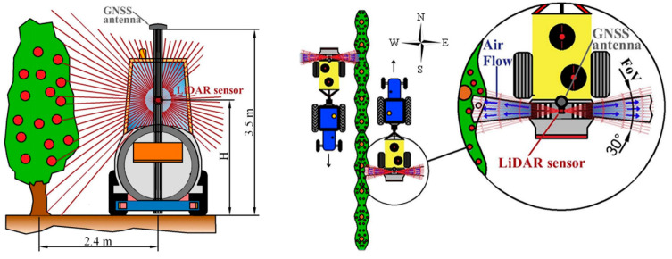
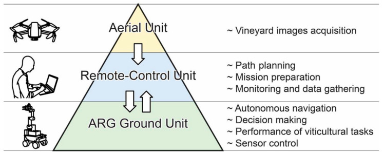
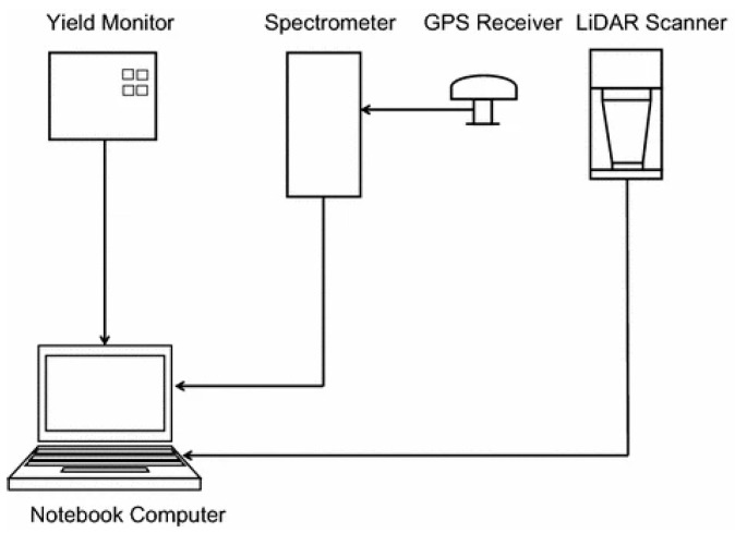
Precision agriculture has revolutionized crop management and agricultural production, with LiDAR technology attracting significant interest among various technological advancements. This extensive review examines the various applications of LiDAR in precision agriculture, with a particular emphasis on its function in crop cultivation and harvests. The introduction provides an overview of precision agriculture, highlighting the need for effective agricultural management and the growing significance of LiDAR technology. The prospective advantages of LiDAR for increasing productivity, optimizing resource utilization, managing crop diseases and pesticides, and reducing environmental impact are discussed. The introduction comprehensively covers LiDAR technology in precision agriculture, detailing airborne, terrestrial, and mobile systems along with their specialized applications in the field. After that, the paper reviews the several uses of LiDAR in agricultural cultivation, including crop growth and yield estimate, disease detection, weed control, and plant health evaluation. The use of LiDAR for soil analysis and management, including soil mapping and categorization and the measurement of moisture content and nutrient levels, is reviewed. Additionally, the article examines how LiDAR is used for harvesting crops, including its use in autonomous harvesting systems, post-harvest quality evaluation, and the prediction of crop maturity and yield. Future perspectives, emergent trends, and innovative developments in LiDAR technology for precision agriculture are discussed, along with the critical challenges and research gaps that must be filled. The review concludes by emphasizing potential solutions and future directions for maximizing LiDAR's potential in precision agriculture. This in-depth review of the uses of LiDAR gives helpful insights for academics, practitioners, and stakeholders interested in using this technology for effective and environmentally friendly crop management, which will eventually contribute to the development of precision agricultural methods.
Keywords: LiDAR technology; autonomous harvesting systems; crop management; disease detection; precision agriculture; yield estimation.
Conflict of interest statement
The authors declare no conflicts of interest.
Figures
References
-
- Bongiovanni R., Lowenberg-DeBoer J. Precision Agriculture and sustainability. Precis. Agric. 2004;5:359–387. doi: 10.1023/B:PRAG.0000040806.39604.aa. - DOI
-
- Jin Y., Liu J., Xu Z., Yuan S., Li P., Wang J. Development status and trend of agricultural robot technology. Int. J. Agric. Biol. Eng. 2021;14:1–19. doi: 10.25165/j.ijabe.20211404.6821. - DOI
-
- Tahilyani S., Saxena S., Karras D.A., Gupta S.K. Deployment of autonomous vehicles in agricultural and using Voronoi partitioning; Proceedings of the 2022 International Conference on Knowledge Engineering and Communication Systems (ICKES); Chickballapur, India. 28–29 December 2022.
-
- Sparks A. Master’s Thesis. Michigan Technological University; Houghton, MI, USA: 2016. Use of LiDAR in the Design of Grassed Waterways: Case Study in Agricultural Management in Oklahoma.
-
- Di Stefano F., Chiappini S., Gorreja A., Balestra M., Pierdicca R. Mobile 3D scan LiDAR: A literature review. Geomatics, Natural Hazards and Risk. Geomatics. 2021;12:2387–2429.
Publication types
MeSH terms
Substances
Grants and funding
LinkOut - more resources
Full Text Sources
