. 2024 Aug 10;10(16):e36101.
doi: 10.1016/j.heliyon.2024.e36101. eCollection 2024 Aug 30.

Where is the heat threat in a city? Different perspectives on people-oriented and remote sensing methods: The case of Prague

Affiliations

Where is the heat threat in a city? Different perspectives on people-oriented and remote sensing methods: The case of Prague

Veronika Květoňová et al. Heliyon. .

Abstract

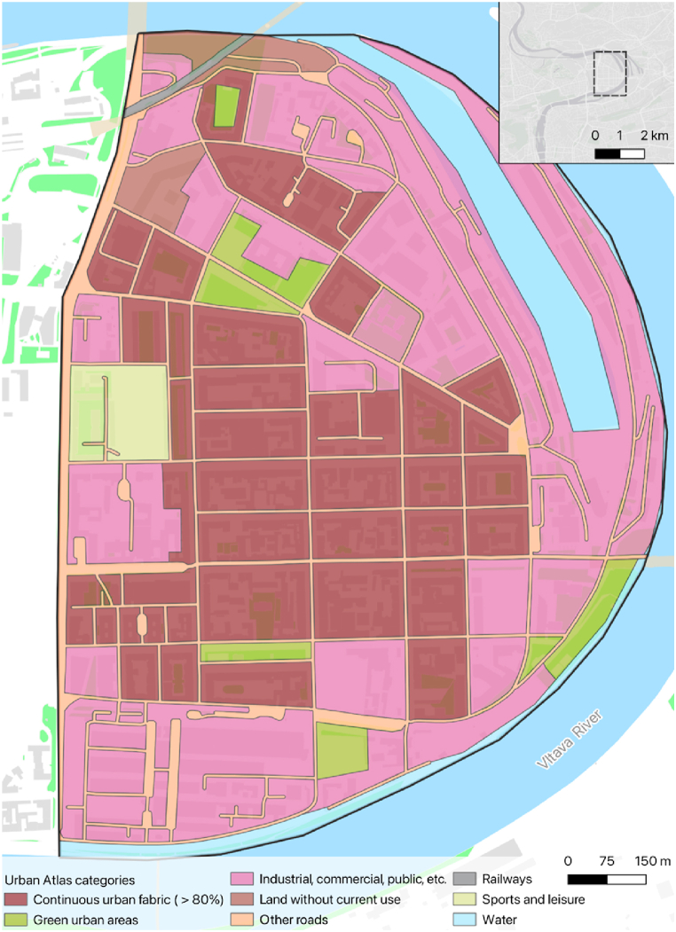
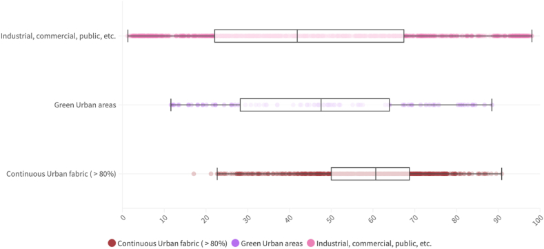
Extreme heat in urban areas has a severe impact on urban populations worldwide. In light of the threats posed by climate change, it is clear that more holistic and people-oriented approaches to reducing heat stress in urban areas are needed. From this perspective we aim to identify and compare thermal hotspots and places with favourable thermal conditions, based on three different methods - thermal walk, participatory-based cognitive mapping, and remote sensing in a Central European city. Although major hotspots in large low-rise development zones were identified by all three methods, the overall agreement between on-site thermal sensation votes, cognitive maps and surface temperatures is low. In the urban canyon of compact mid-rise and open mid-rise development, the thermal walk method proved to be useful in the identification of the specific (parts of) streets and public spaces where citizens can expect thermal discomfort and experience heat stress, e.g. crossroads, arterial streets with a lack of greenery, north facing unshaded parts of streets, and streets with inappropriate tree spacing. Cognitive maps on an urban neighbourhood scale are not specific enough on a street level; however, as a supplementary method they can help identify discrepancies between on-site sensations and thermal conditions. For further research on effective and cost-efficient urban heat mitigation, we suggest combining thermal walks with numerical model simulations.

Keywords: Climate adaptation; Land surface temperature; Participatory mapping; Thermal comfort; Thermal walk.


Conflict of interest statement

The authors declare that they have no known competing financial interests or personal relationships that could have appeared to influence the work reported in this paper.

Figures

Fig. 1
Fig. 1
Urban Atlas classes in the study area.
Fig. 2
Fig. 2
The research design of the study (TSV – Thermal Sensation Vote, RTDS – Reported Thermal Discomfort Score, RTCS – Reported Thermal Comfort Score, LST – Land Surface Temperature).
Fig. 3
Fig. 3
LEFT: Thermal Sensation Votes before standardisation. RIGHT: Percentile of Standardised Thermal Sensation Votes (STSV) in the study area. Points of low STSV are coloured in green, and points of high STSV are coloured in red.
Fig. 4
Fig. 4
LEFT: Mental hotspots defined by percentiles of Reported Thermal Discomfort Score (RTDS) identified by participatory mapping in the study area. RIGHT: Mental coolspots defined by percentiles of Reported Thermal Comfort Score (RTCS) identified by participatory mapping in the study area. Areas of the 75th and higher percentile are highlighted in red/green colour. The thin lines delineate hotspots/coolspots based on the 90th and higher percentile of RTDS/RTCS and the bold lines delineate hotspots/coolspots based on the 95th and higher percentile of RTDS/RTCS.
Fig. 5
Fig. 5
LEFT: The average Land Surface Temperature (LST) derived from 15 representative scenes. RIGHT: LST derived from ECOSTRESS (August 3rd, 2022). Areas of low LST are coloured in blue, and areas of high LST are coloured in red. The thin lines delineate hotspots based on the 90th and higher percentile of LST, and the bold lines delineate hotspots based on the 95th and higher percentile of LST.
Fig. 6
Fig. 6
Boxplot of the percentile of Thermal Sensation Vote (TSV) for dominant Urban Atlas classes in the study area.
Fig. 7
Fig. 7
Boxplot of the percentile of the difference of Reported Thermal Discomfort Score (RTDS) and Reported Thermal Comfort Score (RTCS) for dominant Urban Atlas classes in the study area.
Fig. 8
Fig. 8
Boxplot of the percentile of Land Surface Temperature (LST) derived from 15 representative scenes (LANDSAT-9, LANDSAT-8, ECOSTRESS) for dominant Urban Atlas classes in the study area.
Fig. 9
Fig. 9
Boxplot of the percentile of Land Surface Temperature (LST) derived from 8 representative afternoon scenes (ECOSTRESS) for dominant Urban Atlas classes in the study area.
Fig. 10
Fig. 10
Boxplot of the percentile of Land Surface Temperature (LST) derived from ECOSTRESS (August 3rd, 2022) for dominant Urban Atlas classes in the study area.
Fig. A.1
Fig. A.1
Demographic structure of respondents involved in the participatory-based mapping campaign.
Fig. A.2
Fig. A.2
Percentile of the sum of Reported Thermal Discomfort Score (RTDS) and Reported Thermal Comfort Score (RTCS) identified by participatory-based mapping campaign in the study area. Areas of low percentile are highlighted in light grey and areas of high percentile are highlighted in dark grey colour.
Fig. A.3
Fig. A.3
The average Land Surface Temperature (LST) derived from 8 representative afternoon scenes (ECOSTRESS) in the study area. Areas of low LST are coloured in blue, and areas of high LST are coloured in red. The thin line delineates hotspots based on the 90th and higher percentile of LST, and the bold lines delineate hotspots based on the 95th and higher percentile of LST.

References

    1. IPCC . In: Contribution of Working Groups I, II and III to the Sixth Assessment Report of the Intergovernmental Panel on Climate Change [Core Writing Team. Lee H., Romero J., editors. IPCC; Geneva, Switzerland: 2023. Climate change 2023: synthesis report; pp. 35–115. - DOI
    1. UNPD . United Nations; New York: 2019. World Urbanization Prospects: the 2018 Revision (ST/ESA/SER.A/420) - DOI
    1. Kleerekoper L., van Esch M., Salcedo T.B. How to make a city climate-proof. addressing the urban heat island effect. Resour. Conserv. Recycl. 2012;64:30–38. doi: 10.1016/j.rescokoninrec.2011.06.004. - DOI
    1. Stewart I.D. A systematic review and scientific critique of methodology in modern urban heat island literature. Int. J. Climatol. 2011;31(2):200–217. doi: 10.1002/joc.2141. - DOI
    1. Stewart I.D. Why should urban heat island researchers study history? Urban Clim. 2019;30(A) doi: 10.1016/j.uclim.2019.100484. - DOI

LinkOut - more resources