

Spatial correlation assessment of multiple earthquake intensity measures using physics-based simulated ground motions
- PMID: 39261635
- PMCID: PMC11391078
- DOI: 10.1038/s41598-024-72241-1
Spatial correlation assessment of multiple earthquake intensity measures using physics-based simulated ground motions
Abstract
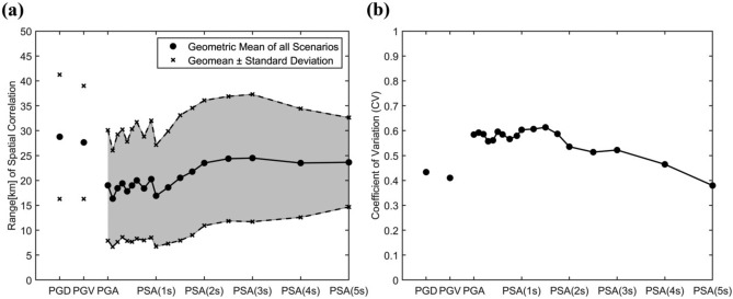
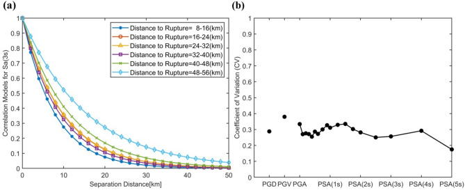
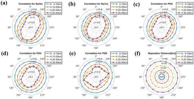
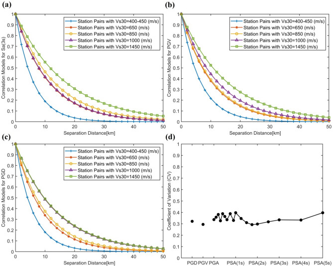
Predictive models for spatial correlation play an effective role in the assessment of seismic risk associated with distributed infrastructure and building portfolios. However, existing models often rely on simplified approaches, assuming isotropy and stationarity. This paper verifies these assumptions by presenting a comprehensive study using a database of 3D physics-based simulated broadband ground motions for Istanbul, generated by the SPEED software. The results reveal significant event-to-event variability and nonstationary and anisotropic characteristics of spatial correlation influenced by source, path, and site effects. The development of nonstationary correlation models requires exploring influential metrics beyond spatial proximity and gaining a deep understanding of their impact, which is the focus of this study. Analysis of the spatial correlations of peak ground displacement, peak ground velocity, peak ground acceleration, and response spectral accelerations at different periods, employing both stationary and nonstationary correlation modelling methods and considering the finite fault model, indicates that the slip distribution pattern, direction and distance of station pairs relative to earthquake rupture, soil softness, and homogeneity of soil properties significantly influence the spatial correlations of near-field earthquake ground motions. Implementation of the introduced parameters in predictive spatial correlation models enhances the precision of regional seismic hazard assessments.
Keywords: 3D physics-based numerical simulation; Near-source ground motion; Regional seismic hazard; Spatial correlation.
© 2024. The Author(s).
Conflict of interest statement
The authors declare no competing interests.
Figures


References
-
- Weatherill, G., Silva, V., Crowley, H. & Bazzurro, P. Exploring the impact of spatial correlations and uncertainties for portfolio analysis in probabilistic seismic loss estimation. Bull. Earthq. Eng.13, 957–981. 10.1007/s10518-015-9730-5 (2015). 10.1007/s10518-015-9730-5 - DOI
-
- Lee, R. & Kiremidjian, A. S. Uncertainty and correlation for loss assessment of spatially distributed systems. Earthq. Spectra23, 753–770. 10.1193/1.2791001 (2007). 10.1193/1.2791001 - DOI
-
- Jayaram, N. & Baker, J. W. Efficient sampling and data reduction techniques for probabilistic seismic lifeline risk assessment. Earthq. Eng. Struct. Dyn.39, 1109–1131. 10.1002/eqe.988 (2010). 10.1002/eqe.988 - DOI
-
- Sokolov, V. & Wenzel, F. Areal exceedance of ground motion as a characteristic of multiple-site seismic hazard: Sensitivity analysis. Soil Dyn. Earthq. Eng.126, 105770. 10.1016/j.soildyn.2019.105770 (2019). 10.1016/j.soildyn.2019.105770 - DOI
-
- Dong, Y. & Frangopol, D. M. Probabilistic assessment of an interdependent healthcare–bridge network system under seismic hazard. Struct. Infrastruct. Eng.13, 160–170. 10.1080/15732479.2016.1198399 (2017). 10.1080/15732479.2016.1198399 - DOI
LinkOut - more resources
Full Text Sources
