

Urbanization, loneliness and mental health model - A cross-sectional network analysis with a representative sample
- PMID: 39443642
- PMCID: PMC11499986
- DOI: 10.1038/s41598-024-76813-z
Urbanization, loneliness and mental health model - A cross-sectional network analysis with a representative sample
Erratum in
-
Publisher Correction: Urbanization, loneliness and mental health model - A cross-sectional network analysis with a representative sample.Sci Rep. 2025 Jan 9;15(1):1517. doi: 10.1038/s41598-024-84233-2. Sci Rep. 2025. PMID: 39789051 Free PMC article. No abstract available.
Abstract
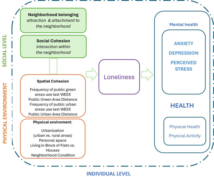
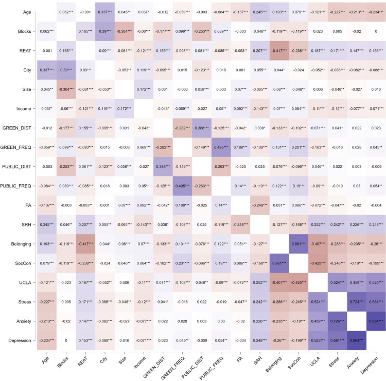
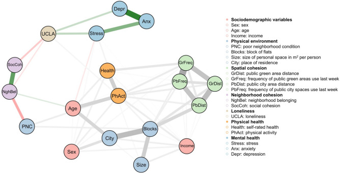
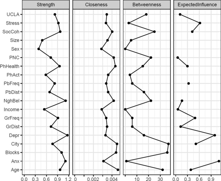
With increasing urbanization, more people are exposed to mental health risk factors stemming from the urban social or physical environment. However, research on the relationship between urbanization and mental health is lacking. This cross-sectional study aimed to explore the relationships of the physical environment (spatial cohesion and urban environment) and social factors (neighborhood cohesion) with mental health (stress, anxiety and depression symptoms) and physical health and the mediating role of loneliness based on the proposed theoretical model. The study was conducted in Metropolis GZM (Silesia, Poland) in a representative sample of 3296 residents (48% women). The measurements used were the PSS-10, GAD-7, PHQ-9, R-UCLA3 and neighborhood cohesion scale. ANOVA results showed that city residents had better mental health indices than residents of villages and small towns. The network approach revealed that urbanization was one of the most influential nodes and played the role of a bridge between all other nodes. The model was confirmed and showed that the relationships between the physical environment and mental health were consecutively mediated by neighborhood cohesion and loneliness. Spatial cohesion related to factors of the physical environment and physical health, while physical health was directly connected to sociodemographic factors and weakly to stress. Anxiety was the strongest risk factor. Mental health can be improved by social and architectural factors, such as strengthening neighborhood cohesion and improving neglected buildings.
© 2024. The Author(s).
Figures

Similar articles
-
Loneliness, physical activity, and mental health during COVID-19: a longitudinal analysis of depression and anxiety in adults over the age of 50 between 2015 and 2020.Int Psychogeriatr. 2021 May;33(5):505-514. doi: 10.1017/S1041610220004135. Epub 2020 Dec 17. Int Psychogeriatr. 2021. PMID: 33327988 Free PMC article.
-
The relationship between urbanization and depression in China: the mediating role of neighborhood social capital.Int J Equity Health. 2018 Jul 24;17(1):105. doi: 10.1186/s12939-018-0825-x. Int J Equity Health. 2018. PMID: 30041631 Free PMC article.
-
Unique Effects of Perceived Neighborhood Physical Disorder and Social Cohesion on Episodic Memory and Semantic Fluency.Arch Clin Neuropsychol. 2019 Nov 27;34(8):1346-1355. doi: 10.1093/arclin/acy098. Arch Clin Neuropsychol. 2019. PMID: 30715092
-
Social relationships, loneliness, and mental health among older men and women in Ireland: A prospective community-based study.J Affect Disord. 2016 Nov 1;204:59-69. doi: 10.1016/j.jad.2016.06.032. Epub 2016 Jun 14. J Affect Disord. 2016. PMID: 27337705
-
Loneliness and mental well-being in the Polish population during the COVID-19 pandemic: a cross-sectional study.BMJ Open. 2022 Feb 1;12(2):e056368. doi: 10.1136/bmjopen-2021-056368. BMJ Open. 2022. PMID: 35105595 Free PMC article.
Cited by
-
Green space attributes and their impact on perceived stress in Poland.Sci Rep. 2025 Apr 22;15(1):13863. doi: 10.1038/s41598-025-98707-4. Sci Rep. 2025. PMID: 40263565 Free PMC article.
References
-
- Adli, M. et al. Neurourbanism—a joint methodological approach between urban planning and neurosciences. Die Psychiatrie 13, 70–78 (2016).
-
- UNDP. Human Development Report 2021–22: Uncertain Times, Unsettled Lives: Shaping our Future in a Transforming World (PDF). hdr.undp.org. United Nations Development Programme, 272–276 (2022). ISBN 978–9–211–26451–7.
-
- van der Wal J.M., et al. Advancing urban mental health research: from complexity science to actionable targets for intervention. Lancet Psychiatry. 8, 991–1000; 10.1016/S2215-0366(21)00047-X (2021). - PubMed
-
- Peen, J., et al. The current status of urban-rural differences in psychiatric disorders. Acta Psychiatr Scand. 121, 84–93; 10.1111/j.1600-0447.2009.01438.x (2010). - PubMed
-
- Baxter, A.J. et al. Global prevalence of anxiety disorders: a systematic review and meta-regression. Psychol Med. 43, 897–910; 10.1017/S003329171200147X (2013). - PubMed
MeSH terms
LinkOut - more resources
Full Text Sources
Medical
