

Integrated approach to predicting habitat suitability and evaluating quality variations of Notopterygium franchetii under climate change
- PMID: 39505945
- PMCID: PMC11541729
- DOI: 10.1038/s41598-024-77824-6
Integrated approach to predicting habitat suitability and evaluating quality variations of Notopterygium franchetii under climate change
Abstract
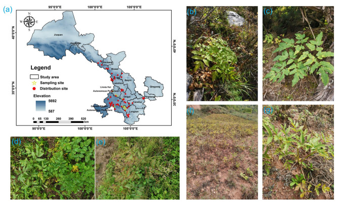
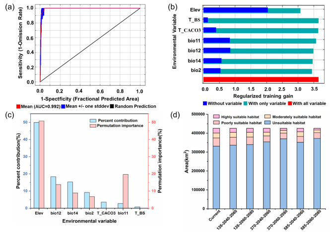
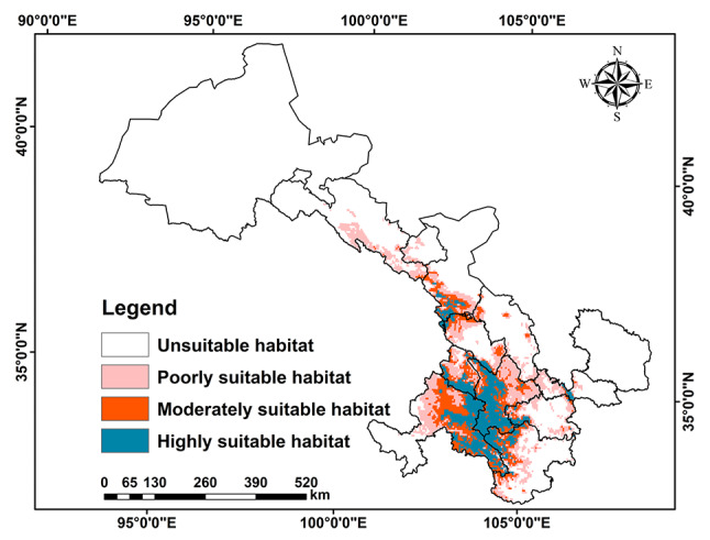
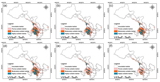
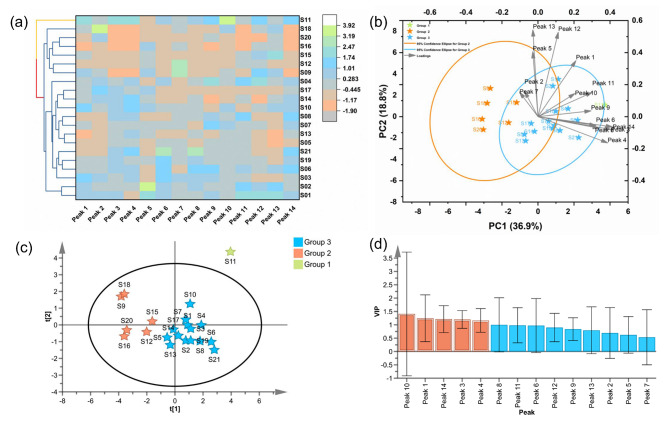
The impact of climate change on medicinal plants has significantly altered their suitable environments, thereby affecting the quality of herbal medicines. Notopterygium franchetii (N. franchetii), a medicinal plant intricately linked to its natural habitat, exhibits substantial quality variations influenced by the ecological conditions of its native region. In this study, comprehensive field surveys were conducted to gather occurrence records and samples of N. franchetii. The Maxent model and ArcGIS software were employed to predict the suitable habitats of N. franchetii during different time periods. A high-performance liquid chromatography (HPLC) method was developed to establish the chemical fingerprints of 21 sample batches. Fourteen common peaks were subjected to cluster analysis, principal component analysis, and orthogonal partial least squares-discriminant analysis. The findings revealed quality variations correlated with their geographic origins, identifying peaks 10, 1, 14, 3, and 4 as crucial for quality differentiation. The study indicates that precipitation, temperature, and altitude significantly influence the distribution of N. franchetii. Under current climate conditions, the suitable habitat area for N. franchetii is estimated to be approximately 94,637.33 km2. However, projections under three future climate scenarios suggest a declining trend in suitable habitat areas. A quality zoning map of N. franchetii was developed, integrating a correlation model between chemical composition and environmental variables with the spatial analysis and visualization capabilities of ArcGIS. The high-quality regions for N. franchetii are predominantly located in the Gannan, Linxia, Dingxi, Longnan, and Wuwei districts. These research outcomes offer a valuable reference for identifying suitable cultivation areas and assessing the quality of N. franchetii in Gansu Province.
Keywords: Notopterygium franchetii; Climate change; Ecological suitability; MaxEnt model; Quality evaluation.
© 2024. The Author(s).
Conflict of interest statement
The authors declare no competing interests.
Figures


References
-
- Zhan, P. et al. Assessment of suitable cultivation region for Panax notoginseng under different climatic conditions using MaxEnt model and high-performance liquid chromatography in China. Ind. Crop. Prod.176, 114416 (2022). - DOI
-
- Chandora, R. et al. Ecological survey, population assessment and habitat distribution modelling for conserving Fritillaria roylei—A critically endangered Himalayan medicinal herb. S. Afr. J. Bot.160, 75–87 (2023). - DOI
-
- Dad, J. M. & Rashid, I. Differential responses of Kashmir Himalayan threatened medicinal plants to anticipated climate change. Environ. Conserv.49, 33–41 (2022). - DOI
-
- Huang, Z. et al. Geographic distribution and impacts of climate change on the suitable habitats of Zingiber species in China. Ind. Crop. Prod.138, 111429 (2019). - DOI
MeSH terms
Grants and funding
LinkOut - more resources
Full Text Sources
Medical
