

Impacts of Sea Level Rise on Danish Coastal Wetlands - a GIS-based Analysis
- PMID: 39611951
- PMCID: PMC11965245
- DOI: 10.1007/s00267-024-02096-9
Impacts of Sea Level Rise on Danish Coastal Wetlands - a GIS-based Analysis
Abstract
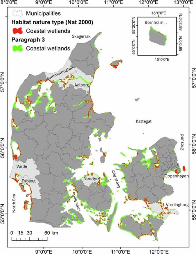
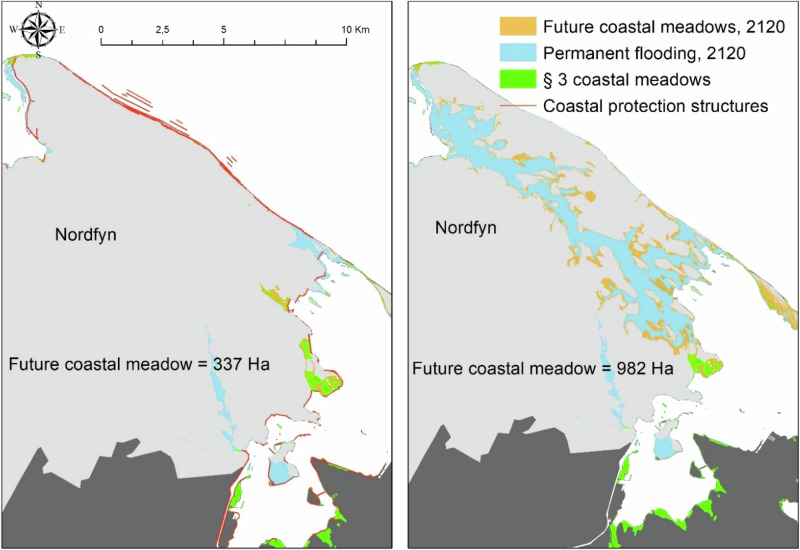
Intergovernmental Panel on Climate Change (IPCC) scenarios run by an ensemble of models developed by the Coupled Model Intercomparison Project (CMIP) projects an average sea level rise (SLRs) of 0.6 to 1.2 m for the low and high emission scenarios (SSP1-1.9, SSP5-8.5), during the next century (IPCC 2021). The coastal zone will experience an increase in the flooding of terrestrial habitats and the depth of marine productive areas, with potential negative consequences for these ecosystems. The coast in Denmark is highly modified due to anthropogenic uses. Dikes, dams, and other coastal infrastructure are widespread, causing a coastal squeeze that prevents natural coastal development and inland migration of coastlines. We performed a national-scale analysis on the impacts of mean sea level rise (MSLR) in 2070 and 2120, and a 1 in 10-year storm surge water level (10SS) in 2120 MSLR for the Danish coast. Our study shows extensive permanent flooding of coastal habitats (~14%), whereas only 1.6% of urban areas will be flooded. Finally, very large agricultural areas (~191,000 ha) will be frequently flooded by 10SS if no extra protective measures are planned. With the present coastal protection structures, key habitats will be affected by permanent flooding or coastal squeeze while even larger extents will be subjected to intermittent marine flooding. About 45% (199 km2) of all Danish coastal wetlands will be permanently flooded by 2120, while areas occupied by forest, lakes and freshwater wetlands will be more frequently flooded by marine water. This study highlights the importance of including coastal habitats as dynamic elements in climate adaptation plans. Conservation and restoration of key habitats such as coastal wetlands should be prioritized in management plans. If Denmark does not change its current priorities, it may face the complete loss of coastal wetlands habitat in the 22nd century.
Keywords: Climate change; Coastal flooding; Coastal meadows, Salt marshes; Coastal nature; Danish national Spatial plans; Sea level rise.
© 2024. The Author(s).
Conflict of interest statement
Compliance with ethical standards. Conflict of interest: The authors declare no competing interests.
Figures


References
-
- Allen JRL (1990). Salt-marsh growth and stratification: a numerical model with special reference to the severn Estuary, southwest Britain. Marine Geology, 77–96
-
- Andersen KJ (2022). Review of flood vulnerability and damage assessments in three Nordic countries. Report published by the Finnish environment Institute & the Danish Coastal Authority. Retrieved from https://kyst.dk/publikationer/oversvoemmelse/review-of-flood-vulnerabili...
-
- Bartholdy AT, Bartholdy J, Kroon A (2010) Salt marsh stability and patterns of sedimentation across a backbarrier platform. Mar Geol 278:31–42
-
- Bartholdy J, Christiansen C, Kunzendorf H (2004) Long term variations in back-barrier salt marsh deposition on the Skallingen peninsula – the Danish Waden Sea. Mar Geol 203:1–21
-
- Bartholdy J, Aagaard T (2000) Storm surge effects on a back-barrier tidal flat of the Danish Wadden Sea. Geo-Mar Lett 20:133–141
MeSH terms
LinkOut - more resources
Full Text Sources
