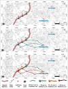
Investigating emergency rescue readiness on Indian national highways: A case study of Jaipur-Jodhpur Highways (India) using a geospatial approach
- PMID: 39722916
- PMCID: PMC11668479
- DOI: 10.4103/jfmpc.jfmpc_1024_24
Investigating emergency rescue readiness on Indian national highways: A case study of Jaipur-Jodhpur Highways (India) using a geospatial approach
Abstract
Background: Highways represent the most significant capital asset that any country's public sector holds. A system of national highways with easy access to ambulance and trauma centers is termed emergency rescue ready and helps reduce the mortality due to road accidents. Given the rich impetus for road infrastructure development by the government of India, there is a need to consider emergency rescue readiness on highways. Previous research suggests that on typical Indian highways, an ambulance can reach the accident scene within 30 minutes; the remaining 30 minutes of golden hour is essential for saving the life of the injured by admitting to a healthcare facility with a trauma unit.
Objective: To investigate the emergency rescue readiness for a stretch of highway between two cities in India. The main objective is to determine the possibility of transporting the injured due to the accident on the highway to the nearest available trauma center within 30 minutes.
Methods: A Geographic Information System (GIS)-based network analysis method has been adopted to find the possibility of transporting the injured anywhere on the circuit of a national highway to the nearest healthcare unit within 30 minutes.
Results: A map representing the status of emergency rescue readiness has been presented for the study area. For a circuit of national highway with a length of 805 km, in a stretch of 89.5% (718.5 km), the injured can be transported to the healthcare unit within 30 minutes. In the remaining 10.5% of the highway, the healthcare units are significantly far from the highways and may hamper the post-crash rescue operations.
Conclusion: There exists a wide disparity in trauma care delivery in the study area. Currently, the healthcare units established to serve the areas with dense populations also serve as emergency rescues during accidents on the national highways. Using GIS techniques for highway stretches with difficulty reaching the trauma centers, a national-level assessment is highly recommended.
Keywords: Emergency rescue; national highways; road accidents; trauma care.
Copyright: © 2024 Journal of Family Medicine and Primary Care.
Conflict of interest statement
There are no conflicts of interest.
Figures


Similar articles
-
Road accidents on Indian National highways, ambulance reachability and transportation of injured to trauma facility: Survey-based introspection of golden hour.J Family Med Prim Care. 2024 Feb;13(2):704-712. doi: 10.4103/jfmpc.jfmpc_1832_23. Epub 2024 Feb 22. J Family Med Prim Care. 2024. PMID: 38605810 Free PMC article.
-
Victims of road accidents with serious injuries and dependence on some individual, climatic and infrastructure factors on federal highways in Brazil.Int J Inj Contr Saf Promot. 2020 Sep;27(3):355-361. doi: 10.1080/17457300.2020.1778040. Epub 2020 Jun 12. Int J Inj Contr Saf Promot. 2020. PMID: 32529896
-
Pediatric Readiness and Trauma Center Access for Children.JAMA Pediatr. 2025 Apr 1;179(4):455-462. doi: 10.1001/jamapediatrics.2024.6058. JAMA Pediatr. 2025. PMID: 39899287
-
Making road safety a public health concern for policy-makers in India.Natl Med J India. 2006 May-Jun;19(3):126-33. Natl Med J India. 2006. PMID: 16836261
-
Pre-hospital care of road traffic accident victims in the Niger Delta: a private initiative and experience.Open Access Emerg Med. 2019 Mar 12;11:51-56. doi: 10.2147/OAEM.S178384. eCollection 2019. Open Access Emerg Med. 2019. PMID: 30881153 Free PMC article. Review.
References
-
- Azmi AA, Ram S. Accident victim characteristics and identification of key parameters for compensation in Indian context. Urban Plan Transp Res. 2023;11:2235418. doi:10.1080/21650020.2023.2235418.
-
- Global status report on road safety 2023. [[Last accessed on 2024 Apr 25]]. Available from: https://iris.who.int/bitstream/handle/10665/375016/97892400⇋7-eng.pdf?se... .
-
- Road Accidents in India 2021. New Delhi: Min. of Road Transport and Highways Transport Research Wing, Government of India; 2021. [[Last accessed on 2024 Apr 25]]. Available from: https://morth.nic.in/sites/default/files/RA_2021_Compressed.pdf .
-
- Year End Review- 2022: Ministry of Road Transport and Highways. [[Last accessed on 2024 Apr 25]]. Available from: https://pib.gov.in/PressReleasePage.aspx?PRID=1888480 .
-
- India has second largest highway network after US: Nitin Gadkari. [[Last accessed on 2024 Apr 25]]. Available from https://indianexpress.com/article/india/india-has-second-largest-highway...
LinkOut - more resources
Full Text Sources
