

Spatiotemporal patterns and drivers of orchard meadow loss in South Tyrol, Italy
- PMID: 39730465
- PMCID: PMC11680714
- DOI: 10.1038/s41598-024-81077-8
Spatiotemporal patterns and drivers of orchard meadow loss in South Tyrol, Italy
Abstract
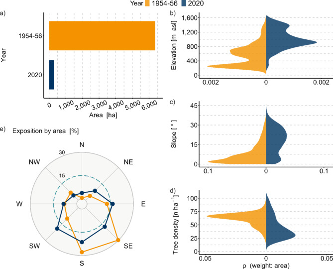
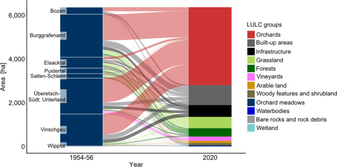
Orchard meadows, a specific agroforestry system characterised by scattered high-stem fruit trees, are a traditional element of several cultural landscapes in Central Europe and provide important ecosystem services. Since the middle of the 20th century, orchard meadows have drastically declined across Europe. Spatial information on the drivers and patterns of such a decline in several regions in Central Europe is lacking. In this study, we aimed to provide the first detailed insights into the development of orchard meadows in South Tyrol. We assessed the current distribution of orchard meadows in South Tyrol (Northern Italy) and analysed the patterns and drivers of their decline over the last 75 years. Aerial images of the orchard meadows in South Tyrol from the 1950s up to the 2020s were examined, and changes in their distribution were statistically analysed. The results revealed that the historical orchard meadow area in South Tyrol has decreased by more than 6,000 ha (-95%) over the past 75 years, showing one of the largest reductions in Central Europe. Orchard meadow loss was highest at lower elevations (-5,155 ha), shallow slopes (-4,313 ha), and expositions towards the south (-5,035 ha). Orchard meadows have declined due to agricultural intensification towards the establishment of modern fruit orchards (56%) and intensively managed grasslands (8%), urbanisation (23%), and reforestation (6%), and other types of land use/land cover (6.5%). Only 0.5% of the traditional orchard meadows have been preserved. The results suggest that orchard meadows are at a high risk of disappearing from the South Tyrolean landscape, resulting in the loss of genetic diversity of many local or indigenous fruit varieties (especially apples and pears). Immediate action is needed to safeguard the current orchard meadow population and appropriate management measures are needed to highlight the multiple values of orchard meadows and provide a valuable alternative to intensive arable farming.
Keywords: Agroforestry; Cultural landscape; Land use/Land cover change; Temperate climate.
© 2024. The Author(s).
Conflict of interest statement
Declarations. Competing interests: The authors declare no competing interests.
Figures


References
-
- den Herder, M. et al. Current extent and stratification of agroforestry in the European union. Agric. Ecosyst. Environ.241, 121–132 (2017). - DOI
-
- Nerlich, K., Graeff-Hönninger, S. & Claupein, W. Agroforestry in Europe: a review of the disappearance of traditional systems and development of modern agroforestry practices, with emphasis on experiences in Germany. Agrofor. Syst.87, 475–492 (2013). - DOI
-
- Nair, P. K. R., Gordon, A. M. & Rosa Mosquera-Losada, M. Agroforestry. In: (eds Jørgensen, S. E. & Fath, B. D.) Encycl. Ecol. 101–110 (Elsevier, 2008).
-
- Plieninger, T. Monitoring directions and rates of change in trees outside forests through multitemporal analysis of map sequences. Appl. Geogr.32, 566–576 (2012). - DOI
-
- Rubio-Delgado, J., Schnabel, S., Lavado-Contador, J. F. & Schmutz, U. Small woody features in agricultural areas: Agroforestry systems of overlooked significance in Europe. Agric. Syst.218, 103973 (2024). - DOI
LinkOut - more resources
Full Text Sources
Miscellaneous
