

Mapping management intensity types in grasslands with synergistic use of Sentinel-1 and Sentinel-2 satellite images
- PMID: 39738429
- PMCID: PMC11685408
- DOI: 10.1038/s41598-024-83699-4
Mapping management intensity types in grasslands with synergistic use of Sentinel-1 and Sentinel-2 satellite images
Abstract
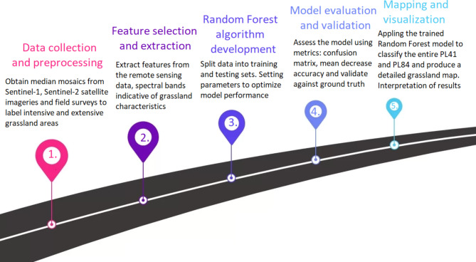
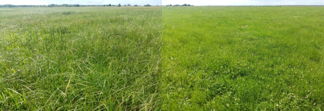
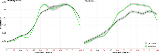
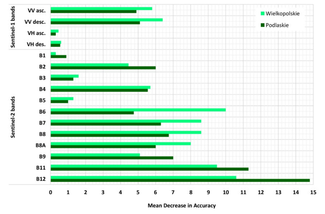
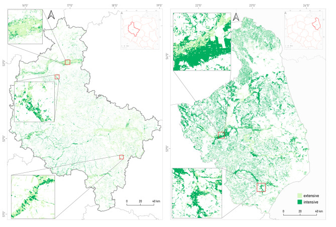
Grasslands, being vital ecosystems with significant ecological and socio-economic importance, have been the subject of increasing attention due to their role in biodiversity conservation, carbon sequestration, and agricultural productivity. However, accurately classifying grassland management intensity, namely extensive and intensive practices, remains challenging, especially across large spatial extents. This research article presents a comprehensive investigation into the classification of grassland management intensity in two distinct regions of Poland, NUTS2 - namely Podlaskie (PL84) and Wielkopolskie (PL41), by integrating data from Sentinel-1 and Sentinel-2 satellite imagery. The study leverages the unique capabilities of Sentinel-1, a radar satellite, and Sentinel-2, an optical multispectral satellite, to overcome the limitations of using a single data source. Preprocessed Sentinel-1 and Sentinel-2 data were combined to extract spectral and textural features, providing valuable insights into grassland characteristics and patterns. Supervised classification using the Random Forest algorithm was used, and ground truth data from field surveys facilitated the creation of training samples. In Podlaskie, extensive grasslands achieved an overall accuracy (OA) of 84%, while intensive grasslands attained an OA of 83%. In Wielkopolskie, extensive grasslands exhibited an OA of 84%, while intensive grasslands achieved an OA of 83%. Additionally, the classification metrics, including user's accuracy (UA), F1 score, and producer's accuracy (PA), further highlighted the variations in classification accuracy. This comprehensive mapping of grassland management intensity using combined Sentinel-1 and Sentinel-2 data provides valuable insights for conservation agencies, agricultural stakeholders, and land managers. The study's findings contribute to sustainable land management and decision-making processes, facilitating the identification of ecologically valuable areas, optimizing agricultural productivity, and assessing the impacts of different management strategies. Furthermore, the research highlights the potential of Sentinel missions for grassland monitoring and emphasizes the importance of advanced remote sensing techniques for understanding and preserving these crucial ecosystems.
Keywords: Backscatter; Ecosystem services; Extensive and intensive managed grassland; Machine learning; Multispectral bands; Satellite imagery.
© 2024. The Author(s).
Conflict of interest statement
Declarations. Competing interests: The authors declare no competing interests.
Figures

References
-
- Bengtsson, J. et al. Grasslands—more important for ecosystem services than you might think. Ecosphere10, e02582. 10.1002/ecs2.2582 (2019).
-
- Boval, M. & Dixon, R. M. The importance of grasslands for animal production and other functions: a review on management and methodological progress in the tropics. Animal6, 748–762. 10.1017/S1751731112000304 (2012). - PubMed
-
- Gabryszuk, M., Barszczewski, J. & Wróbel, B. Characteristics of grasslands and their use in Poland. J. Water Land. Dev.51, 243–249 (2021).
-
- Petermann, J. S. & Buzhdygan, O. Y. Grassland biodiversity. Curr. Biol.31, R1195–R1201. 10.1016/j.cub.2021.06.060 (2021). - PubMed
-
- Siebert, J. et al. Chapter two-extensive grassland-use sustains high levels of soil biological activity, but does not alleviate detrimental climate change effects. Adv. Ecol. Res.60, 25–58. 10.1016/bs.aecr.2019.02.002 (2019).
Grants and funding
LinkOut - more resources
Full Text Sources
