. 2025 Jan 9;15(1):1508.
doi: 10.1038/s41598-024-84083-y.

Assessing the preservation potential of successive hurricane overwash deposits in Florida, USA mangroves

Affiliations

Assessing the preservation potential of successive hurricane overwash deposits in Florida, USA mangroves

Isabel Hong et al. Sci Rep. .

Abstract

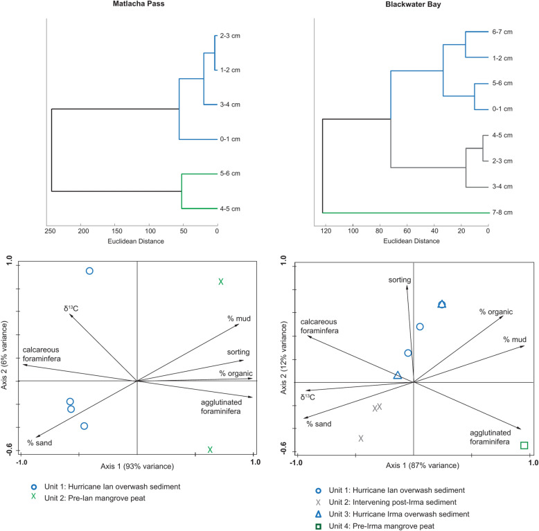
Geologic records of tropical cyclones (TCs) in low-energy, back-barrier environments are established by identifying marine sediments via their allochthonous biogeochemical signal. These records have the potential to reconstruct TC intensity and frequency through time. However, modern analog studies are needed to understand which biogeochemical indicators of overwash sediments are best preserved and how post-depositional changes may affect their preservation. Here, we examine the overwash sediments of two successive land-falling, high-intensity TCs: Hurricane Ian in 2022 and Hurricane Irma in 2017. Hurricane Ian's overwash sediments at two mangrove sites, including one directly along (Matlacha Pass) and one other distal from (Blackwater Bay) Hurricane Ian's path through southwest Florida, USA, were identified as a light gray very poorly to poorly sorted coarse silty sand with marine microfossils and geochemical marine signature. Hurricane Irma's overwash sediments remained identifiable from post-Irma sediments at Blackwater Bay as a gray poorly sorted coarse silt with a marine microfossil signature but lacking a distinctive geochemical signature. The identification of overwash sediments left by TCs occurring in within five years demonstrates the high preservation potential of overwash sediments in low-energy, mangrove environments. Similar environments can be utilized to advance paleotempestology studies in southwest Florida.

Keywords: Foraminifera; Geochemistry; Grain size; Paleotempestology; Sedimentology; Tropical cyclone.


Conflict of interest statement

Declarations. Competing interests: The authors declare no competing interests.

Figures

Fig. 1
Fig. 1
Map figure of study area: Matlacha Pass and Blackwater Bay, southwest Florida, USA. Large map shows the location of Matlacha Pass and Blackwater Bay alongside Hurricane Ian’s track as it passed north-northwest across peninsular Florida, increasing in intensity to Category 4 on the Saffir-Simpson scale before making landfall and crossing Matlacha Pass. Inset maps show location of each site (top: Matlacha Pass; bottom: Blackwater Bay) and distance from storm track. Map created using ArcGIS Pro version 2.9.2.
Fig. 2
Fig. 2
Modern transect results from Matlacha Pass, Florida. From top to bottom: % organic matter (OM) using loss-on-ignition, δ13Cbulk (‰), mean grain size (Φ), and relative foraminifera abundance of species along a mangrove forest transect relative to mean tide level (MTL) that started near open water and moved inland (S1–S8) at Matlacha Pass. Results show Hurricane Ian overwash deposit has lower organic matter content (mean: 12.5%), higher C isotopic values (mean: -13 ‰), and coarser sediment (mean 4.13Φ) than pre-Ian mangrove peat. Foraminiferal abundances in Ian’s overwash deposit at the Matlacha site exhibit an increase in species diversity (18 species on average) and in specimen counts (1194 specimens/cc on average) compared to pre-Ian mangrove sediments (3 species and 71 specimens/cc on average).
Fig. 3
Fig. 3
Downcore results of Hurricane Ian sediments and underlying sediments from Matlacha Pass (top) and Blackwater Bay (bottom), Florida. From left to right: photo of core taken in the field. At Matlacha Pass, Unit 1 is 0–3.5 cm depth and Unit 2 is 3.5–6 cm depth. At Blackwater Bay, Unit 1 is 0–1 cm depth, Unit 2 is shown 1–4.5 cm depth, Unit 3 is 4.6–6 cm depth, and Unit 4 is 6–8 cm depth. Scatter plots display grain size statistics mean and sorting (Φ), % organic matter (OM) from loss-on-ignition, δ13Cbulk, % sand, % mud, % calcareous foraminifera, and % agglutinated foraminifera.
Fig. 4
Fig. 4
Modern transect results from Blackwater Bay, Florida. From top to bottom: % organic matter (OM) using loss-on-ignition, δ13Cbulk (‰), mean grain size (Φ), and relative foraminifera abundance of species along a mangrove forest transect relative to mean tide level that started near open water and moved inland (S1–S12) at Blackwater Bay. Results show Hurricane Ian overwash deposit has low organic matter content (mean: 16%), high C isotopic values (mean: -15.1 ‰), and coarse sediment (mean 5.65 Φ). Foraminiferal abundances in Ian’s overwash deposit at the Blackwater site exhibit a high abundance of calcareous species (95 ± 6%) and high species diversity (16 species on average) and in specimen counts (586 specimens/cc on average).
Fig. 5
Fig. 5
(top) Hierarchical cluster results and (bottom) PCA sample-environment biplot results from Blackwater Bay (left) and Matlacha Pass (right) cores. Station symbols indicate stratigraphic unit (Unit 1 = circle; Unit 2 = cross; Unit 3 = triangle; Unit 4 = square) and colors indicate cluster (blue = overwash sediment; gray = very coarse silt with organics; green = mangrove peat). Vectors indicate environmental variables.

References

    1. Dinan, T. & Wylie, D. Expected Costs of Damage From Hurricane Winds and Storm-Related Flooding. US Congr. Budg. Off. (2019)
    1. Monthly Global Climate Report for December 2022. NOAA National Centers for Environmental Informationhttps://www.ncei.noaa.gov/access/monitoring/monthly-report/global/202300 (2023).
    1. Mendelsohn, R., Emanuel, K., Chonabayashi, S. & Bakkensen, L. The impact of climate change on global tropical cyclone damage. Nat. Clim. Change2, 205–209 (2012).
    1. Weaver, M. M. & Garner, A. J. Varying genesis and landfall locations for North Atlantic tropical cyclones in a warmer climate. Sci. Rep.13, 5482 (2023). - PMC - PubMed
    1. Crossett, K., Ache, B., Pacheco, P. & Haber, K. National coastal population report, poepulation trends from 1970 to 2020. NOAA State Coast Rep. Ser. (2013).

LinkOut - more resources