. 2025 Jan 7;122(1):e2416699122.
doi: 10.1073/pnas.2416699122. Epub 2024 Dec 30.

The 1831 CE mystery eruption identified as Zavaritskii caldera, Simushir Island (Kurils)

Affiliations

The 1831 CE mystery eruption identified as Zavaritskii caldera, Simushir Island (Kurils)

William Hutchison et al. Proc Natl Acad Sci U S A. .

Abstract

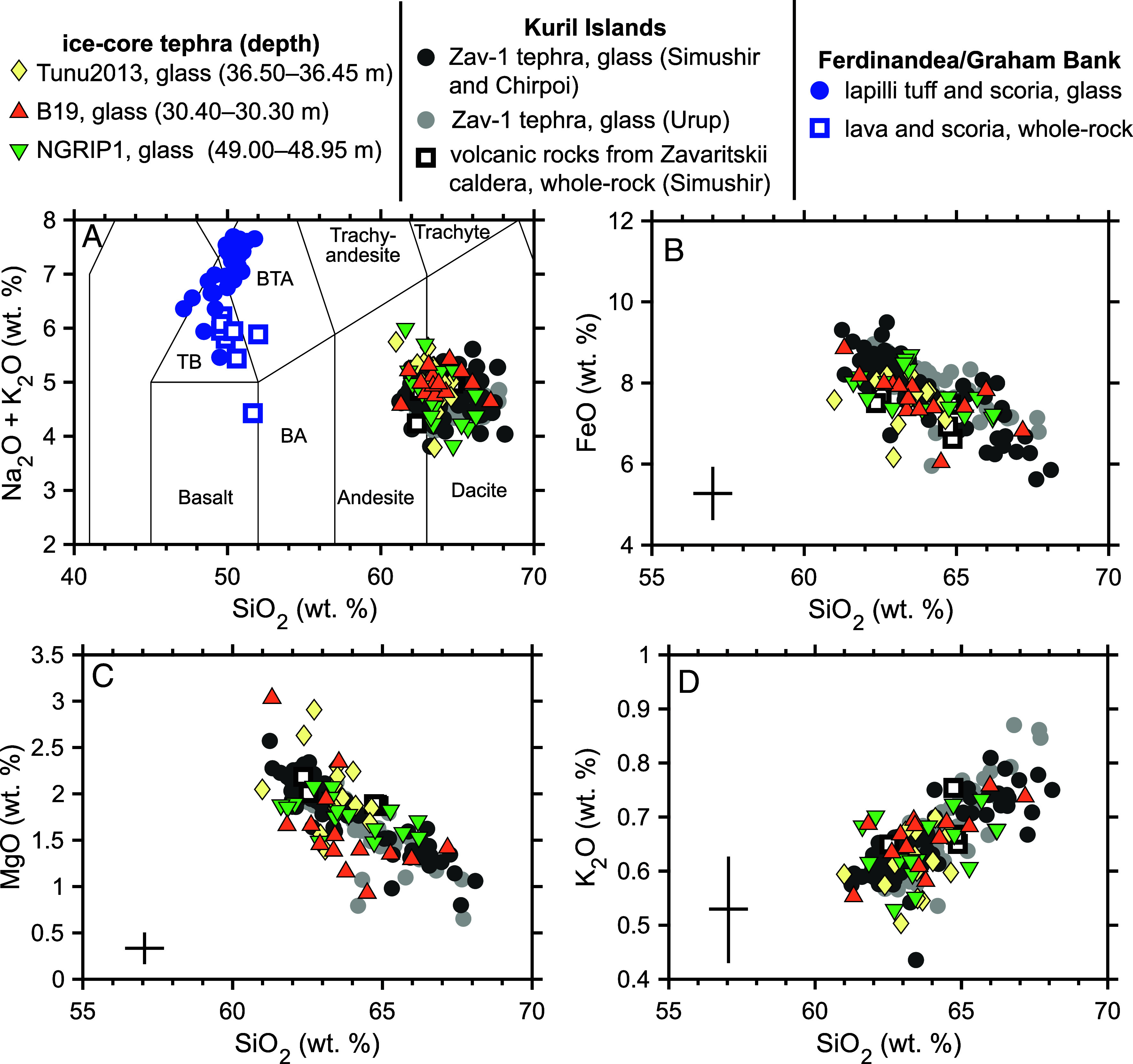
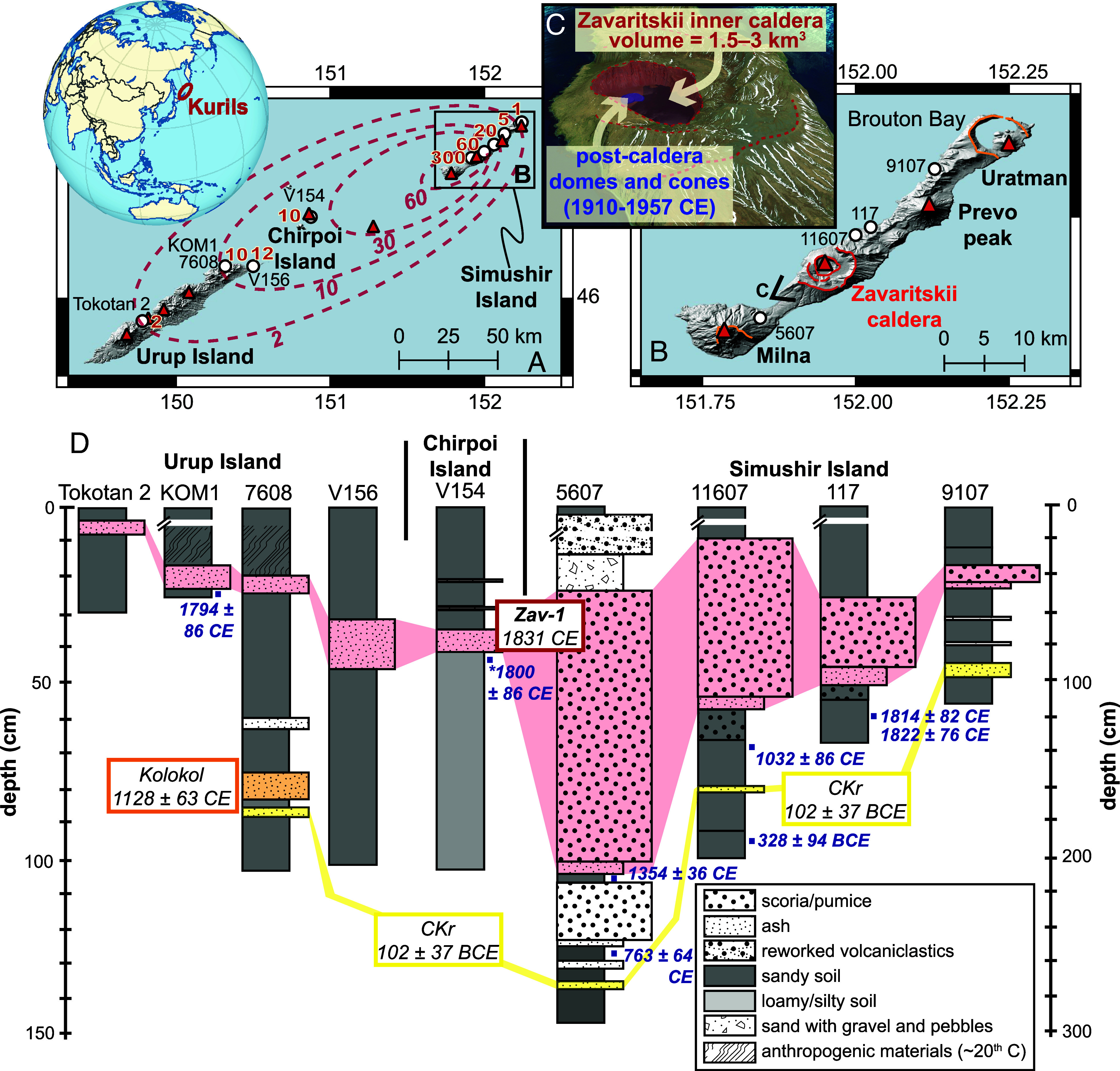
Polar ice cores and historical records evidence a large-magnitude volcanic eruption in 1831 CE. This event was estimated to have injected ~13 Tg of sulfur (S) into the stratosphere which produced various atmospheric optical phenomena and led to Northern Hemisphere climate cooling of ~1 °C. The source of this volcanic event remains enigmatic, though one hypothesis has linked it to a modest phreatomagmatic eruption of Ferdinandea in the Strait of Sicily, which may have emitted additional S through magma-crust interactions with evaporite rocks. Here, we undertake a high-resolution multiproxy geochemical analysis of ice-core archives spanning the 1831 CE volcanic event. S isotopes confirm a major Northern Hemisphere stratospheric eruption but, importantly, rule out significant contributions from external evaporite S. In multiple ice cores, we identify cryptotephra layers of low K andesite-dacite glass shards occurring in summer 1831 CE and immediately prior to the stratospheric S fallout. This tephra matches the chemistry of the youngest Plinian eruption of Zavaritskii, a remote nested caldera on Simushir Island (Kurils). Radiocarbon ages confirm a recent (<300 y) eruption of Zavaritskii, and erupted volume estimates are consistent with a magnitude 5 to 6 event. The reconstructed radiative forcing of Zavaritskii (-2 ± 1 W m-2) is comparable to the 1991 CE Pinatubo eruption and can readily account for the climate cooling in 1831-1833 CE. These data provide compelling evidence that Zavaritskii was the source of the 1831 CE mystery eruption and solve a confounding case of multiple closely spaced observed and unobserved volcanic eruptions.

Keywords: climate; ice cores; sulfur isotopes; tephra; volcanoes.


Conflict of interest statement

Competing interests statement:The authors declare no competing interest.

Figures

Fig. 1.
Fig. 1.
Glaciochemical records from Greenland ice-cores (NEEM-2011-S1 (A), NGRIP1 (B), B19 (C), and Tunu2013 (D)). Sulfur (S) and non-sea-salt sulfur (nssS) are shown on the left-hand axis (blue line; in ng/g). In the lower panel of (A) Na concentrations (orange line; in ng/g) from NEEM-2011-S1 are shown and reveal seasonal cycles with values peaking in midwinter due to increased storms (and hence increased transport of marine aerosol from the sea surface and sea ice). Particle concentrations (gray line; in μg/g) are shown on the right-hand axis and correspond to the 4.5 to 9.5 μm size fraction. Ice-core cryptotephra are shown by the colored symbols and are associated with the particle peaks. For NGRIP1 no particle concentration measurements were available but high-time-resolution subsampling allowed us to identify the precise depth interval of tephra (shaded gray). Note that there is a longer time offset between particle and S peaks at lower accumulation rate sites (B19 and Tunu2013, ~100 kg m−2 yr−1 of ice) compared to higher accumulation sites (NGRIP1 and NEEM, ~200 kg m−2 yr−1). Lower accumulation sites are more strongly affected by postdepositional processes (i.e. mixing, erosion, and redistribution of previous snow) and so the high accumulation sites (i.e. NGRIP1 and NEEM) best preserve the original stratigraphy.
Fig. 2.
Fig. 2.
Sulfur concertation (A), δ34S (B), and Δ33S (C) time-series for NGRIP1. Blue-filled symbols are measured values, and the white-filled are background corrected values (for samples with >50 % volcanic sulfate (28, 29). In (C), the gray shaded area shows typical 2σ values of our non-MIF (0 ± 0.15 ‰) secondary standard [Switzer Falls river water (30)]. In AC, the green triangle and gray shaded area show the depth interval of the subsample where cryptotephra were found. (D) shows background corrected volcanic sulfate values from large-magnitude volcanic events [1815 CE Tambora and 1257 CE Samalas (20) and 1991 CE Pinatubo (28)] compared to 1831 CE (this study, the 5 points from the stratospheric peak). The dashed blue line shows an S isotope mass balance model assuming Ferdinandea was the source of the 1831 CE ice-core S peak. The assumptions are summarized in the blue box and article text, but in short, large volumes of external S from Messinian gypsum horizons are required for Ferdinandea to reach the S loading suggested by the ice-core records and cannot explain the measured δ34S–Δ33S array. Ferdinandea model input is based on values from Garrison et al. (10), Liotta et al. (31), and Ziegenbalg et al. (32).
Fig. 3.
Fig. 3.
Major element geochemistry of the 1831 CE ice-core tephra compared to potential candidates. (A) is a total-alkali versus silica diagram and the abbreviations are TB: trachybasalt, BTA: basaltic-trachyandesite, and BA: basaltic-andesite. (B), (C), and (D) show major element biplots of SiO2 versus FeO, MgO and K2O, respectively. Triangles show ice-core tephra glass analyses, circles show glass analyses of proximal tephras and squares show whole-rock analyses of volcanic eruptives. Geochemical data for the 1831 CE eruption of Ferdinandea are shown in blue [this study and (35, 36)]. Zav-1 tephra originate from Zavaritskii caldera (Simushir Island, Kurils). Zav-1 ash and pumice samples from Simushir and Chirpoi Island (Fig. 4A) are shown by the large dark gray symbols. Zav-1 tephra found on Urup Island, ~140 km south-west of Zavaritskii caldera, are shown by large light gray circles. All Zav-1 tephra analyses are from this study (though the analyses were conducted at various times between 2009 and 2024), as detailed in Dataset S3. We also show additional geochemical measurements of volcanic rocks from Zavaritskii [after (–39)]. Error bars give the maximum uncertainty in our ice-core tephra analyses (based on the 2σ values of the closest matrix-matched secondary standards).
Fig. 4.
Fig. 4.
Location map of Zavaritskii caldera, Simushir Island, Kurils. (A) Volcanoes of Simushir and Urup Islands (red triangles) and sites where the Zav-1 tephra has been identified (white circles) with thicknesses in cm (red text). Approximate tephra isopachs are shown by the dashed red lines. (B) Detail of Simushir Island showing volcanoes, caldera outlines (in orange and red), and sampling locations labeled. (C) 3D view of the nested calderas of Zavaritskii, showing the youngest inner caldera (red) and the postcaldera lava domes (blue). (D) Stratigraphic columns showing the youngest volcaniclastic deposits on Simushir, Chirpoi Urup Island. The Zav-1 tephra, which is geochemically matched between these sites (Fig. 3) is shaded red. Ages for the Kolokol and CKr tephra layers are from Razjigaeva et al. (40) and Bergal-Kuvikas et al. (41), respectively. Anthropogenic materials found in the north of Urup Island include ~20th-century objects, i.e., tin cans and shoe leather. Calibrated radiocarbon ages (blue squares and text) are shown in years BCE/CE (mean ± 1σ). On Chirpoi Island the stratigraphy is from site V154 on Peschanaya Bay while the radiocarbon age (*) comes from a hearth deposit beneath Zav-1 also in Peschanaya Bay (42).

References

    1. Robock A., Climate and volcanic eruptions. Rev. Geophys. 38, 191–219 (2000).
    1. Marshall L. R., et al. , Volcanic effects on climate: Recent advances and future avenues. Bull. Volcanol. 84, 54 (2022). - PMC - PubMed
    1. Sigl M., et al. , Timing and climate forcing of volcanic eruptions for the past 2,500 years. Nature 523, 543–549 (2015). - PubMed
    1. Brönnimann S., et al. , Last phase of the little ice age forced by volcanic eruptions. Nat. Geosci. 12, 650–656 (2019).
    1. Timmreck C., et al. The unidentified volcanic eruption of 1809: Why it remains a climatic cold case The atmosphere in the earth system. Clim. Past 17, 1–39 (2021).