

Exploring environmental risk in soils: Leveraging open data for non-sampling assessment?
- PMID: 39811301
- PMCID: PMC11730565
- DOI: 10.1016/j.heliyon.2024.e41247
Exploring environmental risk in soils: Leveraging open data for non-sampling assessment?
Abstract
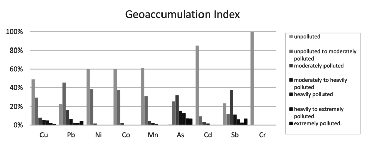
Soil contamination by heavy metals (HM) is a critical area of research. Traditional methods involving sample collection and lab analysis are effective but costly and time-consuming. This study explores whether geostatistical analysis with GIS and open data can provide a faster, more precise, and cost-effective alternative for HM contamination assessment without extensive sampling. Concentrations of nine HMs (Cu, Pb, Ni, Co, Mn, As, Cd, Sb, Cr) were analysed from 498 soil samples collected in two mining areas in Portugal: the Panasqueira and Aljustrel mines. Corresponding data were extracted from the Lucas TOPSOIL 1 km raster maps. Several contamination indices, Contamination Factor (Cf), Modified Contamination Degree (mCd), Geoaccumulation Index (Igeo), Nemerow Pollution Index (Pn), Potential Ecological Risk Index (PERI), and Pollution Load Index (PLI) were calculated for both datasets. A confusion matrix was used to evaluate the percentage of correct classifications, while a concordance analysis assessed the alignment of accurately classified points between the two data sources. In the soil samples, very high contamination levels for As were observed in 42% of the samples, according to the Cf, with high levels for Sb found in approximately 30% of the samples. The mCd revealed that approximately 11% of soil samples exhibited very high levels of contamination, while the Pn indicated that 78.9% of the soil samples fell within the seriously polluted domain. Similar contamination trends were observed for the other indices. In contrast, the results for the LUCAS points showed significant discrepancies. No high contamination levels were found for any metal. The misclassification rates for mCd, Pn, PERI, and PLI were 84.25%, 97.55%, 95%, and 82%, respectively, when compared to the field data. This study concludes that while open data raster maps offer rapid overviews, they fall short of providing the detailed precision required for reliable contamination assessments. The significant misclassification rates observed highlight the limitations of relying solely on these tools for critical environmental decisions. Consequently, traditional sampling and laboratory analysis remain indispensable for accurate risk assessments of HM contamination, ensuring a more reliable foundation for decision-making and environmental management.
Keywords: Comparison of contamination indices; Geostatistical raster maps; Heavy metal contamination assessment; Heavy metal pollution indices; Soil sample data vs raster data.
© 2024 The Authors.
Conflict of interest statement
The authors declare that they have no known competing financial interests or personal relationships that could have appeared to influence the work reported in this paper.
Figures


Similar articles
-
Integrated application of multiple indicators and geographic information system-based approaches for comprehensive assessment of environmental impacts of toxic metals-contaminated agricultural soils and vegetables.Sci Total Environ. 2024 May 20;926:171747. doi: 10.1016/j.scitotenv.2024.171747. Epub 2024 Mar 24. Sci Total Environ. 2024. PMID: 38531460
-
Metal pollution in the topsoil of lands adjacent to Sahiwal Coal Fired Power Plant (SCFPP) in Sahiwal, Pakistan.PLoS One. 2024 Feb 15;19(2):e0298433. doi: 10.1371/journal.pone.0298433. eCollection 2024. PLoS One. 2024. PMID: 38359049 Free PMC article.
-
[Ecological Risk Assessment of Heavy Metals at Township Scale in the High Background of Heavy Metals, Southwestern, China].Huan Jing Ke Xue. 2020 Sep 8;41(9):4197-4209. doi: 10.13227/j.hjkx.201912241. Huan Jing Ke Xue. 2020. PMID: 33124301 Chinese.
-
A review of heavy metals pollution in riverine sediment from various Asian and European countries: Distribution, sources, and environmental risk.Mar Pollut Bull. 2024 Sep;206:116775. doi: 10.1016/j.marpolbul.2024.116775. Epub 2024 Aug 8. Mar Pollut Bull. 2024. PMID: 39121593 Review.
-
Concentration, Spatial Distribution, Contamination Degree and Human Health Risk Assessment of Heavy Metals in Urban Soils across China between 2003 and 2019-A Systematic Review.Int J Environ Res Public Health. 2020 Apr 29;17(9):3099. doi: 10.3390/ijerph17093099. Int J Environ Res Public Health. 2020. PMID: 32365600 Free PMC article.
References
-
- Wuana R.A., Okieimen F.E. Heavy metals in contaminated soils: a review of sources. Chemistry, Risks and Best Available Strategies for Remediation, ISRN Ecol. 2011;2011:1–20. doi: 10.5402/2011/402647. - DOI
-
- Rashid A., Schutte B.J., Ulery A., Deyholos M.K., Sanogo S., Lehnhoff E.A., Beck L. Heavy metal contamination in agricultural soil: environmental pollutants affecting crop health. Agronomy. 2023;13:1521. doi: 10.3390/AGRONOMY13061521/S1. - DOI
-
- Wójcik M., Dresler S., Tukiendorf A. Physiological mechanisms of adaptation of Dianthus carthusianorum L. to growth on a Zn-Pb waste deposit - the case of chronic multi-metal and acute Zn stress. Plant Soil. 2015;390:237–250. doi: 10.1007/S11104-015-2396-6/FIGURES/5. - DOI
LinkOut - more resources
Full Text Sources
Research Materials
Miscellaneous
