

Distribution, sources, and fate of nitrate in groundwater in agricultural areas of Southern Alberta, Canada
- PMID: 39925730
- PMCID: PMC11799072
- DOI: 10.1007/s10533-025-01209-8
Distribution, sources, and fate of nitrate in groundwater in agricultural areas of Southern Alberta, Canada
Abstract
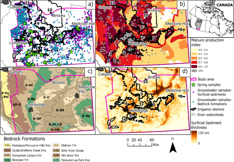
Nitrate pollution frequently impacts groundwater quality, particularly in agricultural regions across the world, but identifying the sources of nitrate (NO3 -) pollution remains challenging. The extensive use of nitrogen-containing fertilizers, surpassing crop requirements, and livestock management practices associated with the spreading of manure can lead to the accumulation and transport of NO3 - into groundwater, potentially affecting drinking water sources. We investigated the occurrence and distribution of NO3 - in groundwater in Southern Alberta, Canada, a region characterized by intensive crop cultivation and livestock industry. Over 3500 samples from a provincial-scale groundwater quality database, collated from multiple projects and sources, involving domestic wells, monitoring wells, and springs, coupled with newly obtained samples from monitoring wells provided comprehensive geochemical insights into groundwater quality. While stable isotope compositions of NO3 - (δ15N and δ18O) were exclusively available for groundwater samples obtained from monitoring wells, the stable isotope data were instrumental in constraining NO3 - sources and transformation processes within the aquifers of the study region. Among all samples, 49% (n = 1746) were associated with NO3 - concentrations below the detection limits. Ten percent (n = 369) of all groundwater samples, including samples with concentrations below detection limits, exceed the Canadian drinking water maximum acceptable concentration of 10 mg/L for nitrate as nitrogen (NO3 --N). Elevated NO3 - concentrations (> 10 mg/L as NO3 --N) in groundwater were mainly detected at shallow depths (< 30 m) predominantly in aquifers in surficial sediments and less frequently in bedrock aquifers. Statistical correlations between aqueous geochemical parameters showed positive associations between concentrations of NO3 --N and both potassium (K+) and chloride (Cl-), indicating the influence of synthetic fertilizers on groundwater quality. In addition, isotope analyses of NO3 - (δ15N and δ18O) revealed three NO3 - sources in groundwater, including mineralization of soil organic nitrogen followed by nitrification in soils, nitrification of ammonium or urea-based synthetic fertilizers in soils, and manure. However, manure was identified as the dominant source of NO3 - exceeding the maximum acceptable concentration in groundwater within agriculturally dominated areas. Additionally, this multifaceted approach helped identify denitrification in some groundwater samples, a process that plays a key role in reducing NO3 - concentrations under favorable redox conditions in shallow aquifers. The methodological approach used in this study can be applied to other regions worldwide to identify NO3 - sources and removal processes in contaminated aquifers, provided there are well networks in place to monitor groundwater quality and drinking water sources.
Supplementary information: The online version contains supplementary material available at 10.1007/s10533-025-01209-8.
Keywords: Agriculture; Fertilizers; Groundwater quality; Manure; Nitrate.
© The Author(s) 2025.
Conflict of interest statement
Conflict of interestThe authors have no relevant financial or non-financial interests to disclose.
Figures


References
-
- ABMI (2019) Alberta Biodiversity Monitoring Institute and Alberta Human Footprint Monitoring Program. ABMI human footprint inventory (HFI) for Alberta 2019 (version 1.0). Geodatabase. ABMI
-
- Aitchison J (1982) The statistical analysis of compositional data. J R Stat Soc B 44(2):139–160. 10.1111/J.2517-6161.1982.TB01195.X
-
- Alberta Agriculture Food and Rural Development, AAFRD (2005) Agricultural land resource atlas of Alberta, 25 maps, 2nd edn. Alberta Agriculture, Food and Rural Development, Resource Management and Irrigation Division, Conservation and Development Branch, Edmonton. https://www.alberta.ca/agricultural-land-resource-atlas-of-alberta
-
- Alberta Health (2014) Domestic well water quality in Alberta, 2002–2008, characterization. Physical and chemical testing. Alberta Health
-
- AMEC (2009) South Saskatchewan River Basin in Alberta: water supply study. Alberta Agriculture and Rural Development, Lethbridge
LinkOut - more resources
Full Text Sources