. 2025 Feb 9;25(4):1020.
doi: 10.3390/s25041020.

Monte Carlo Guidance for Better Imaging of Boreal Lakes in the Wavelength Region of 400-800 nm

Affiliations

Monte Carlo Guidance for Better Imaging of Boreal Lakes in the Wavelength Region of 400-800 nm

Vinh Nguyen Du Le. Sensors (Basel). .

Abstract

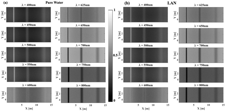
Boreal lake depth, one of the most important parameters in numerical weather prediction and climate models through parametrization, helps in identifying notable environmental changes across the globe and in estimating its effect on the ecosystem in remote regions. However, there is no quantitative tool to effectively estimate lake depth from satellite images, leaving scientists to infer lake depth from extrapolation of statistics by relying on certain geological knowledge (such as those used in the Global Lake Database). The bottoms of boreal forest lakes are mainly composed of woody debris, and thus spectral imaging revealing contrast of woody debris can be used to estimate lake depth. Here, we use well-established Monte Carlo software to construct spectral images of boreal lakes that house woody debris, phytoplankton, and chlorophyll. This is accomplished by modeling the dynamic optical properties of selected boreal lakes and simulating the propagation of photons in the wavelength region of 400-800 nm. The results show that the spectral image contrast of boreal lakes is not only determined by the depth level and concentration level of phytoplankton and chlorophyll in water but is also affected by the spectral shape of background absorption, especially the contribution of pure water absorption in the total absorption of lake water.

Keywords: Landsat; Monte Carlo; absorption; boreal lake; image contrast; optical properties; scattering.


Conflict of interest statement

The author declares no conflicts of interest.

Figures

Figure 1
Figure 1
Monte Carlo simulation of photon interaction with boreal lake water and escape to the surface: (a) 3-D MCX model of woody debris in a simulated volume of lake water, (b) photon depth fluence in log-scale, (c) spectral reflectance image, (d) and the corresponding intensity profile across the X-dimension and how image contrast is calculated. Wood cylinders are located at depths of 2, 5, and 7.5 m and have a diameter of 20 cm.
Figure 2
Figure 2
Optical properties of lake water vary significantly, depending on the abundancy of phytoplankton (major absorber) and of chlorophyll (major scatterers), and are wavelength dependent. (a) Absorption coefficient spectrum of pure water, lake Äntu Sinijärv (LAN), lake Päijänne (LPA), lake Vôrtsjärv (LVO), lake Valkekotinen (LVA); (b) lake water reduced scattering coefficient spectrum at different chlorophyll concentration C; (c) exemplary Henyey–Greenstein phase functions with normalized polar plots in inset at high and low anisotropy values; (d) optical properties of woody debris. Here, each lake is identified by their signature phytoplankton concentration, so that LVA represents lake water with the highest phytoplankton. Chlorophyll concentration will be varied or fixed depending on each dataset below.
Figure 3
Figure 3
Spectral images of woody debris at different depths in (a) pure (clear) water, (b) lake Äntu Sinijärv (LAN), (c) lake Päijänne (LPA), (d) lake Vôrtsjärv (LVO), and (e) lake Valkekotinen (LVA) across the 400–800 nm region of the EM spectrum. In this figure, the concentration of chlorophyll in water is C = 10 mg.m−3. These images were normalized to maximum intensity values in each image.
Figure 3
Figure 3
Spectral images of woody debris at different depths in (a) pure (clear) water, (b) lake Äntu Sinijärv (LAN), (c) lake Päijänne (LPA), (d) lake Vôrtsjärv (LVO), and (e) lake Valkekotinen (LVA) across the 400–800 nm region of the EM spectrum. In this figure, the concentration of chlorophyll in water is C = 10 mg.m−3. These images were normalized to maximum intensity values in each image.
Figure 4
Figure 4
Calculated image contrast of woody debris at different depths across the 400–800 nm region of the EM spectrum considering a concentration of chlorophyll of C = 10 mg.m−3 in (a) pure water, (b) LAN, (c) LPA, (d) LVO, and (e) LVA. Figure (f) plots the contrast spectra for pure water, LAN, and LVA at a depth of 5.0 m.
Figure 5
Figure 5
Images of woody debris at three different depths in lake Äntu Sinijärv as scattering increases (increasing concentration of chlorophyll). Images at three wavelengths, 400, 600, and 700 nm, were selected for demonstration.
Figure 6
Figure 6
Images of woody debris at three different depths in lake Valkekotinen as scattering increases (increasing concentration of chlorophyll). Images at three wavelengths, 400, 600, and 700 nm, were selected for demonstration.
Figure 7
Figure 7
The effect of scattering (concentration of chlorophyll, C) on the contrast spectrum in pure water (ac) and lake Valkekotinen (df) at different depths: (a,d) 25 cm, (b,e) 50 cm, (c,f) 75 cm.

References

    1. Riordan B., Verbyla D., McGuire A.D. Shrinking ponds in subarctic Alaska based on 1950–2002 remotely sensed images. J. Geophys. Res. Biogeosci. 2006;111 doi: 10.1029/2005JG000150. - DOI
    1. Roach J.K., Griffith B., Verbyla D. Landscape influences on climate–related lake shrinkage at high latitudes. Global Change Biol. 2013;19:2276–2284. doi: 10.1111/gcb.12196. - DOI - PubMed
    1. Carroll M.L., Townshend J., DiMiceli C., Loboda T., Sohlberg R. Shrinking lakes of the Arctic: Spatial relationships and trajectory of change. Geophys. Res. Lett. 2011;38:286. doi: 10.1029/2011GL049427. - DOI
    1. Klein E., Berg E.E., Dial R. Wetland drying and succession across the Kenai Peninsula lowlands, south-central Alaska. Can. J. For. Res. 2005;35:1931–1941. doi: 10.1139/x05-129. - DOI
    1. Smith L.C., Sheng Y., MacDonald G., Hinzman L. Disappearing Arctic lakes. Science. 2005;308:1429. doi: 10.1126/science.1108142. - DOI - PubMed

LinkOut - more resources