. 2025 Mar 7;15(1):7994.
doi: 10.1038/s41598-025-91950-9.

Modeling Intraday Aedes-human exposure dynamics enhances dengue risk prediction

Affiliations

Modeling Intraday Aedes-human exposure dynamics enhances dengue risk prediction

Steffen Knoblauch et al. Sci Rep. .

Abstract

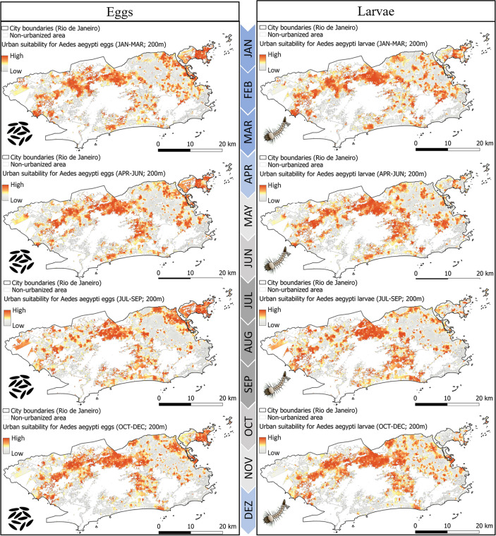
Cities are the hot spots for global dengue transmission. The increasing availability of human movement data obtained from mobile devices presents a substantial opportunity to address this prevailing public health challenge. Leveraging mobile phone data to guide vector control can be relevant for numerous mosquito-borne diseases, where the influence of human commuting patterns impacts not only the dissemination of pathogens but also the daytime exposure to vectors. This study utilizes hourly mobile phone records of approximately 3 million urban residents and daily dengue case counts at the address level, spanning 8 years (2015-2022), to evaluate the importance of modeling human-mosquito interactions at an hourly resolution in elucidating sub-neighborhood dengue occurrence in the municipality of Rio de Janeiro. The findings of this urban study demonstrate that integrating knowledge of Aedes biting behavior with human movement patterns can significantly improve inferences on urban dengue occurrence. The inclusion of spatial eigenvectors and vulnerability indicators such as healthcare access, urban centrality measures, and estimates for immunity as predictors, allowed a further fine-tuning of the spatial model. The proposed concept enabled the explanation of 77% of the deviance in sub-neighborhood DENV infections. The transfer of these results to optimize vector control in urban settings bears significant epidemiological implications, presumably leading to lower infection rates of Aedes-borne diseases in the future. It highlights how increasingly collected human movement patterns can be utilized to locate zones of potential DENV transmission, identified not only by mosquito abundance but also connectivity to high incidence areas considering Aedes peak biting hours. These findings hold particular significance given the ongoing projection of global dengue incidence and urban sprawl.

Keywords: Aedes biting rates; Daytime exposure; Human movement; Spatial eigenvector mapping; Urban dengue transmission; Urban mobility.


Conflict of interest statement

Declarations. Competing interests: The authors declare no conflict of interest.

Figures

Fig. 1
Fig. 1
Pearson’s correlation coefficients between yearly dengue incidence and percentage share of population in urban areas for PAHO (Pan American Health Organization) countries between 1960 and 2021. This analysis explores the potential association between urban growth and the increase in global DENV occurrence, recognizing that correlation does not necessarily imply causation (left). Urban cycle of DENV transmission, highlighting the role of human movement and limited mosquito flight range for disease occurrence (right).
Fig. 2
Fig. 2
Workflow for the sub-neighborhood spatial eigenvector mapping of urban DENV occurrence applying entomological surveillance (left) and call detail records (middle) to model daytime human-mosquito biting risk for the municipality of Rio de Janeiro in Brazil on an hourly basis. Voronoi tessellations based on mobile phone antenna locations were employed as the spatial unit for analysis. In the feature engineering process, the base model assumed a constant human-mosquito interaction throughout the day, while the proposed model accounted for the fluctuating exposure of humans to mosquito bites, considering the twilight biting activity of Aedes mosquitoes and the hourly commuting patterns of humans. Note that this workflow identifies associations at an aggregate level and should be interpreted with caution to avoid ecological fallacies, as it does not imply causation at the individual level. (CDRs: Call detail records; ORS: OpenRouteService; IGBE: Brazilian Institute of Geography and Statistics; IPEA: Institute of Applied Economic Research; SMS-RJ: Municipal Health Ministry of Rio de Janeiro).
Fig. 3
Fig. 3
A 200 m grid displaying statistically significant hotspots, cold spots, and spatial outliers derived from daily DENV health records collected for the municipality of Rio de Janeiro between January 2015 and December 2022. Spatial autocorrelation and the identification of clusters with similar or dissimilar values were assessed using the Anselin Local Moran’s I statistic. In this context, ‘High–High’ clusters represent areas with high DENV occurrence surrounded by neighboring areas with similarly high occurrence, and ‘Low–Low’ clusters indicate areas with low occurrence surrounded by low-occurrence neighbors. Areas colored white indicate the absence of significant spatial autocorrelation in dengue occurrence. (created using ArcGIS).
Fig. 4
Fig. 4
Daytime human population density in the municipality of Rio de Janeiro, estimated by using mobile phone data. Hourly changes in antenna activity behave differently in various zones of the case study region, as shown for two selected subregions. While the dominant mobility motif in the northwest district involved movement between three locations, the southeast district exhibited a dominant mobility motif characterized by movement between two locations. (created using QGIS).
Fig. 5
Fig. 5
Human movement patterns used for spatial eigenvector mapping of DENV occurrence in the municipality of Rio de Janeiro. Spatial weights were estimated applying mobile phone records from July 2021 to July 2022. Thick dark black edges represent high human connectivity between antenna locations, whereas thin and bright black stripes indicate a lower amount of human movements. (created using FlowmapBlue).
Fig. 6
Fig. 6
Novel vector control planning map considering daytime mosquito activity and human movement flows for the municipality of Rio de Janeiro. The figure illustrates the discrepancy between DENV occurrence and estimated mosquito abundance at an urban scale. Areas of dark red color represent target effectiveness zones measured by entomological surveillance. The black-striped Voronoi tesselations highlight potential danger areas for transmission that might be underestimated when relying solely on entomological surveillance or reported dengue cases. The identification of these zones relied on hourly-weighted propagated dengue occurrence HP-DENVi, weighted by biting activity, to reflect the locations of infected persons during the days denoted as HP-DENVi=h=124w(h)·DENV·j=1hODj. Within the black-striped Voronoi tessellations, sub-regions with high mosquito suitability are particularly relevant to guide interventions. (created using QGIS).
Figure 7
Figure 7
Seasonal urban suitability for A. aegypti eggs (left) and larvae (right) at a 200-meter resolution within the municipality of Rio de Janeiro for the year 2019, generated in a prior study. The analysis employed a complementary approach integrating entomological surveillance data from ovitraps, ecological knowledge concerning limited mosquito flight range, and urban landscape indicators relevant to infer immature A. aegypti suitability. The blue timescale on the left indicates the wet and dry season. (created using QGIS).
Fig. 8
Fig. 8
Entomological surveillance data collected via household survey called LIRA.MinisteriodaSaudeBrazil.2013 Maps display the house index (left) and breteau index (right) for A. aegypti (top) and A. albopictus (bottom) averaged over 48 seasonal LIRA surveys between 2015 and 2022. (created using QGIS).
Fig. 9
Fig. 9
Normalized centrality of OSM road network measured by travel time in car for the municipality of Rio de Janeiro. (created using QGIS).
Fig. 10
Fig. 10
Healthcare accessibility measured by travel time using an equal modal split of car, public transport, bicycle and walk for the municipality of Rio de Janeiro. (created using QGIS).
Fig. 11
Fig. 11
Comparison between the age distribution of DENV-infected individuals, determined by the time interval between birth and notification date in the official health system, and the overall age structure in Rio de Janeiro municipality as per the 2022 census. For the calculation of the average infection age, official health records from January 2015 to December 2022 were applied. The age structure of infected persons roughly aligns with the general demographic structure.
Fig. 12
Fig. 12
Daily fluctuations of DENV case counts and serotype dominance in the municipality of Rio de Janeiro from 2015 to 2022. Larger outbreaks in 2015, 2016, and 2019 co-occur with dominant serotype switches. Days indicated by white stripes indicate a lack of serotype tests in the official health database; many of these gaps also coincide with the COVID-19 pandemic.
Fig. 13
Fig. 13
Exemplary spatial eigenvectors derived from the model’s spatial weight matrix illustrating distinct patterns: Spatial eigenvector 2 shows gradual spatial gradients, and spatial eigenvector 135 depicts localized clustering. These eigenvectors unveil varying spatial structures within the study area, providing valuable insights into the underlying spatial relationships influencing the observed phenomena. (created using QGIS).

References

    1. Althouse, B. M. et al. Enhancing disease surveillance with novel data streams: Challenges and opportunities. EPJ Data Sci.10.1140/epjds/s13688-015-0054-0 (2015). - PMC - PubMed
    1. Sattenspiel, L. & Lloyd, A. The Geographic Spread of Infectious Diseases: Models and Applications 5th edn. (Princeton University Press, 2009).
    1. Kraemer, M. U. G. et al. Progress and challenges in infectious disease cartography. Trends Parasitol.32, 19–29. 10.1016/j.pt.2015.09.006 (2016). - PubMed
    1. Lenormand, M. et al. Cross-checking different sources of mobility information. PLoS ONE9, e105184. 10.1371/journal.pone.0105184 (2014). - PMC - PubMed
    1. Yuan, Y. & Raubal, M. Extracting dynamic urban mobility patterns from mobile phone data. In Hutchison, D. et al. (eds.) Geographic Information Science, vol. 7478 of Lecture Notes in Computer Science 354–367 (Springer Berlin Heidelberg, Berlin, Heidelberg, 2012). 10.1007/978-3-642-33024-7_26

LinkOut - more resources