. 2025 Mar 10;12(1):414.
doi: 10.1038/s41597-025-04672-y.

Bedmap3 updated ice bed, surface and thickness gridded datasets for Antarctica

Hamish D Pritchard  1 Peter T Fretwell  2 Alice C Fremand  3 Julien A Bodart  4   5 James D Kirkham  3 Alan Aitken  6 Jonathan Bamber  7   8 Robin Bell  9 Cesidio Bianchi  10 Robert G Bingham  11 Donald D Blankenship  12 Gino Casassa  13   14 Knut Christianson  15 Howard Conway  15 Hugh F J Corr  3 Xiangbin Cui  16 Detlef Damaske  17 Volkmar Damm  17 Boris Dorschel  18 Reinhard Drews  19 Graeme Eagles  18 Olaf Eisen  18   20 Hannes Eisermann  18 Fausto Ferraccioli  3   21 Elena Field  3 René Forsberg  22 Steven Franke  19 Vikram Goel  23 Siva Prasad Gogineni  24 Jamin Greenbaum  12   25 Benjamin Hills  26 Richard C A Hindmarsh  3 Andrew O Hoffman  9 Nicholas Holschuh  27 John W Holt  28 Angelika Humbert  18   20 Robert W Jacobel  29 Daniela Jansen  18 Adrian Jenkins  30 Wilfried Jokat  18   20 Lenneke Jong  31   32 Tom A Jordan  3 Edward C King  3 Jack Kohler  33 William Krabill  34 Joséphine Maton  35 Mette Kusk Gillespie  36 Kirsty Langley  37 Joohan Lee  38 German Leitchenkov  39   40 Cartlon Leuschen  41 Bruce Luyendyk  42 Joseph A MacGregor  43 Emma MacKie  44 Geir Moholdt  35 Kenichi Matsuoka  35 Mathieu Morlighem  45 Jérémie Mouginot  46   47 Frank O Nitsche  9 Ole A Nost  48 John Paden  41 Frank Pattyn  49 Sergey Popov  50 Eric Rignot  46   51   52 David M Rippin  53 Andrés Rivera  54 Jason L Roberts  31   32 Neil Ross  55 Antonia Ruppel  17 Dustin M Schroeder  56   57 Martin J Siegert  58 Andrew M Smith  3 Daniel Steinhage  18 Michael Studinger  59 Bo Sun  16 Ignazio Tabacco  10 Kirsty J Tinto  9 Stefano Urbini  10 David G Vaughan  3 Douglas S Wilson  60 Duncan A Young  12 Achille Zirizzotti  10
Affiliations

Bedmap3 updated ice bed, surface and thickness gridded datasets for Antarctica

Hamish D Pritchard et al. Sci Data. .

Abstract

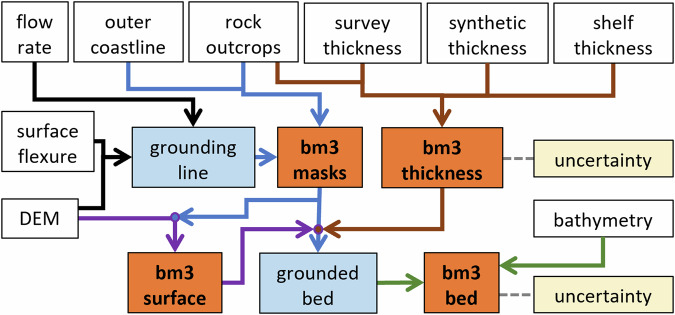
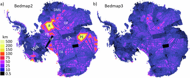
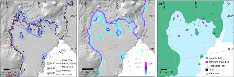
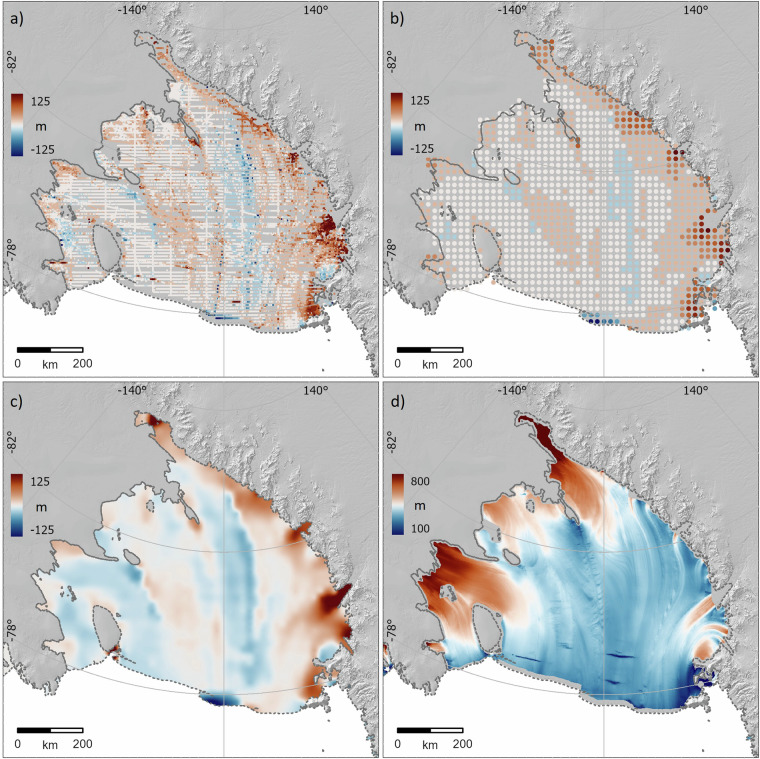
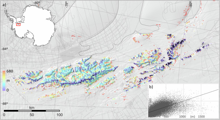
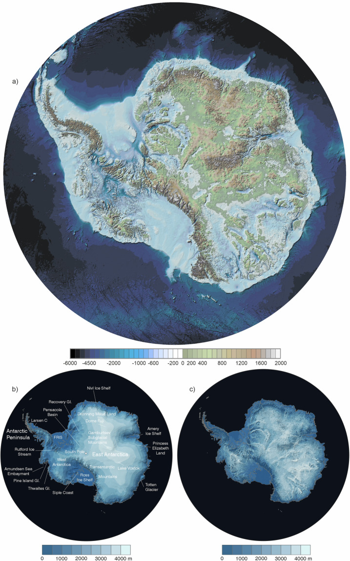
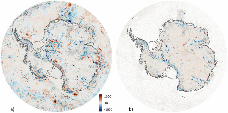
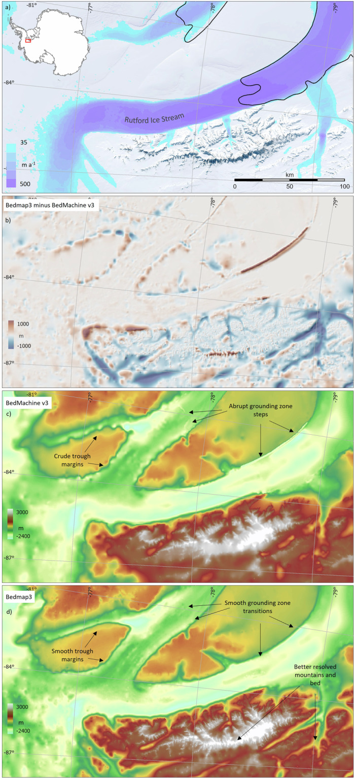
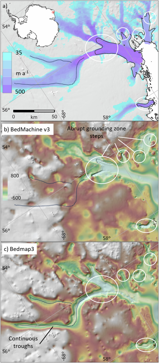
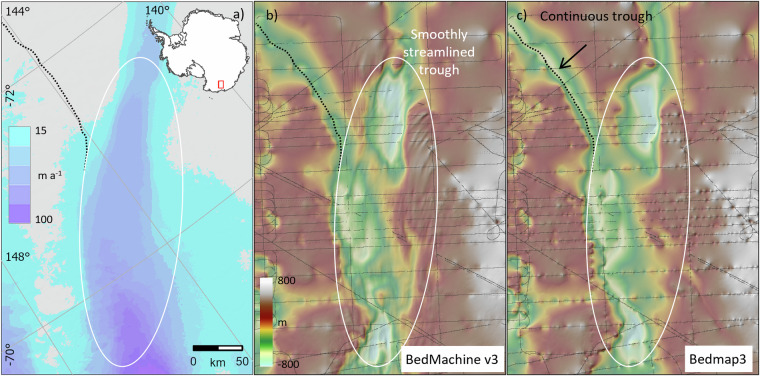
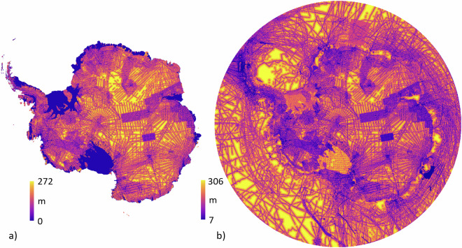
We present Bedmap3, the latest suite of gridded products describing surface elevation, ice-thickness and the seafloor and subglacial bed elevation of the Antarctic south of 60 °S. Bedmap3 incorporates and adds to all post-1950s datasets previously used for Bedmap2, including 84 new aero-geophysical surveys by 15 data providers, an additional 52 million data points and 1.9 million line-kilometres of measurement. These efforts have filled notable gaps including in major mountain ranges and the deep interior of East Antarctica, along West Antarctic coastlines and on the Antarctic Peninsula. Our new Bedmap3/RINGS grounding line similarly consolidates multiple recent mappings into a single, spatially coherent feature. Combined with updated maps of surface topography, ice shelf thickness, rock outcrops and bathymetry, Bedmap3 reveals in much greater detail the subglacial landscape and distribution of Antarctica's ice, providing new opportunities to interpret continental-scale landscape evolution and to model the past and future evolution of the Antarctic ice sheets.


Conflict of interest statement

Competing interests: The authors declare no competing interests.

Figures

Fig. 1
Fig. 1
Schematic showing the Bedmp3 source datasets (white boxes) combining to make intermediate products (blue boxes) and ultimately the final set of grids (orange boxes) and their uncertainties (yellow boxes). Note that the surface grid has a uniform estimated uncertainty (Section Uncertainty estimates).
Fig. 2
Fig. 2
The survey coverage of Antarctica has improved since Bedmap2. This has decreased the distance from interpolated cells to ice thickness survey data (black lines) from that of (a) Bedmap2 (ref. ) to that of (b) Bedmap3. P = Pine Island Glacier, T = Thwaites Glacier, R = Recovery Glacier, PE = Princess Elizabeth Land, SP = South Pole, PB = Pensacola Basin, DML = Dronning Maud Land, AP = Antarctic Peninsula, WA = West Antarctica, EA = East Antarctica, TA = Transantarctic Mountains, DF = Dome Fuji.
Fig. 3
Fig. 3
The new Bedmap3 grounding line seeks to reconcile multiple varying observations. (a) A suite of published grounding lines and associated tidal flexure limits on the Northern Ice Shelf of Pine Island Glacier mapped by InSAR, ICESat, Cryosat2, MODIS and Landsat (Table 1) (background image: shaded relief of surface elevation after ref. ). Note that feature ‘A’ is no longer covered by the ice shelf; (b) a heatmap of grounding line location from multiple lines mapped by InSAR through 2018 (after ref. ); (c) the reconciled Bedmap3 masks of grounded ice, ‘transient grounding’, floating ice shelf and rock, gridded at 500 m. For comparison, M&B 2024 refers to pinning points identified in a separate study.
Fig. 4
Fig. 4
The Bedmap3 survey dataset allows us to calibrate the more continuous and extensive freeboard-based ice shelf thickness grid. (a) Pointwise ice thickness biases between 119,000 survey measurements and the freeboard-derived ice thickness grid on the Ross Ice Shelf, showing coherent patterns of bias; (b) these pointwise offsets median-filtered over a 20 km radius; (c) spline-interpolated calibration grid of the filtered offsets in (b); (d) bias-corrected version of the freeboard-derived ice thickness grid after subtraction of the calibration grid in (c).
Fig. 5
Fig. 5
(a) Synthetic ice thickness of unsurveyed areas in the Ellsworth mountains (within 15 km of rock or within 20 km of the coastline/grounding line). Thin grey lines show thickness surveys, the thick grey line shows the Bedmap3 grounding line, rock outcrops are shown in black. (b) scatterplot showing surveyed thickness (metres, x axis) plotted against calculated ‘Glen’ thicknesses (metres, y axis) and the linear regression line between the two (dashed black line).
Fig. 6
Fig. 6
The depiction of subglacial troughs can be improved by identifying linear features common to multiple neighbouring survey lines. (a) A relatively dense grid of surveyed ice thickness (coloured lines) over the subglacial Gamburtsev Mountains overlain on digitised streamlines (white) that link points of local maximum thickness in neighbouring survey lines. Inset map shows the Antarctic-wide distribution of digitised streamlines in grey; (b) a grid interpolated using only surveyed thicknesses, where troughs appear ‘beaded’; (c) a grid interpolated using both surveyed thicknesses and thicknesses linearly interpolated along streamlines, resulting in smooth trough long profiles.
Fig. 7
Fig. 7
Bedmap3 grids of (a) bed topography and (b) surface elevation, in metres above sea level (g104c geoid), and (c) ice thickness in metres. Locations labelled in (b) are referred to in the text.
Fig. 8
Fig. 8
The Bedmap3 bed elevations can be compared to earlier products. (a) Bedmap3 minus Bedmap2; (b) Bedmap3 minus BedMachine v3 (red indicates that the Bedmap3 bed is higher, blue that it is lower).
Fig. 9
Fig. 9
The Bedmap3 bed has some subjective advantages over BedMachine v3, including smoothly continuous grounding zones and troughs, and better-resolved areas of bed. (a) surface flow speed and Bedmap3 grounding line (solid black) in the Rutford Ice Stream area; (b) map of Bedmap3 minus BedMachine v3 bed topography; (c) BedMachine v3 bed topography; and (d) Bedmap3 bed topography, highlighting areas of difference. Similar BedMachine v3 issues have been reported previously in this area.
Fig. 10
Fig. 10
Bedmap3 features smoothly continuous grounding zones and troughs, in contrast to some sites in BedMachine v3. (a) Surface flow speed and Bedmap3 grounding line (solid black) in the Wilma Glacier region; (b) BedMachine v3 bed topography; (c) Bedmap3 bed topography, both overlaid on shaded relief. The dotted line highlights troughs that are continuous in Bedmap3, white ovals highlight abrupt steps in the BedMachine v3 grounding zone.
Fig. 11
Fig. 11
The BedMachine v3 bed has some subjective advantages over Bedmap3 where glacier flow is relatively fast, but survey data are sparse. (a) Surface flow speed; (b) BedMachine v3 bed topography; (c) Bedmap3 bed topography, both overlaid on shaded relief and with survey data shown as grey lines. The black dotted line highlights a trough under slow-flowing ice that is more smoothly continuous in Bedmap3. The white oval highlights the trough of a relatively fast-flowing ice stream that in BedMachine v3 is more smoothly streamlined and subjectively more realistic than in Bedmap3, given the typical streamlined form of deglaciated ice stream landscapes (e.g., ref. ). An objective test of bed accuracy in this area requires more survey data.
Fig. 12
Fig. 12
Estimated 1-sigma uncertainty map for (a) ice thickness and (b) bed topography. Zero thickness uncertainty in (a) applies to rock areas.

References

    1. FitzGerald, D. M., Fenster, M. S., Argow, B. A. & Buynevich, I. V. Coastal impacts due to sea-level rise. Annu. Rev. Earth Planet. Sci.36, 601–647 (2008).
    1. Rignot, E. & Thomas, R. H. Mass balance of polar ice sheets. Science297, 1502–1506 (2002). - PubMed
    1. Pollard, D. & DeConto, R. M. Modelling West Antarctic ice sheet growth and collapse through the past five million years. Nature458, 329–332 (2009). - PubMed
    1. Coxall, H. K., Wilson, P. A., Pälike, H., Lear, C. H. & Backman, J. Rapid stepwise onset of Antarctic glaciation and deeper calcite compensation in the Pacific Ocean. Nature433, 53–57 (2005). - PubMed
    1. DeConto, R. M. & Pollard, D. Contribution of Antarctica to past and future sea-level rise. Nature531, 591–597 (2016). - PubMed