

Population dynamics, threat assessment, and conservation strategies for critically endangered Meconopsis aculeata in alpine zone
- PMID: 40102752
- PMCID: PMC11921755
- DOI: 10.1186/s12870-025-06361-9
Population dynamics, threat assessment, and conservation strategies for critically endangered Meconopsis aculeata in alpine zone
Abstract
Background: The Himalayan alpine zone harbors a rich diversity of endemic medicinal plant species, such as Meconopsis aculeata, due to its habitat heterogeneity. Globally, alpine environments are most significantly affected by climate change, characterized by low temperatures and restricted growing seasons, offering essential services yet remaining most vulnerable. M. aculeata holds immense ecological significance in alpine ecosystems, while human disturbances and climate change pose serious threats to its long-term viability. The present study was conducted to explore population ecology, spatial distribution patterns, significant threats, diversity patterns along elevational gradients, and future conservation strategies for the dwindling populations of M. aculeata.
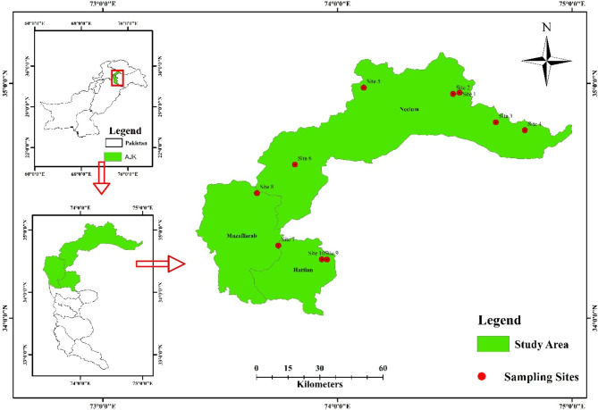
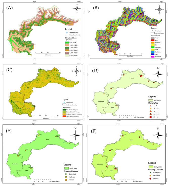
Methods: Field sampling was carried out from 2022 to 2024 in various districts of Kashmir to examine the vegetation characteristics of M. aculeata populations, along with the geographic variables and threats impacting these populations. The quadrat method was used to investigate the vegetation characteristics across an extensive elevational gradient, ranging from 3000 m to 4600 m.
Results: Healthier M. aculeata populations were found in the middle elevational range of 3700 m to 4100 m. The SIMPER analysis revealed an overall average dissimilarity of 80.08, indicating spatial variability in species composition across the studied sites. GIS analysis showed that M. aculeata was found on the north aspect, with steppe slope in rocky habitat. The average herb density was calculated to be 20.6/ha, while 60% of sampled sites experienced intense grazing. A total of 20 indicator species were identified as associated with M. aculeata populations. Mantel tests identified key species influencing the population structure of M. aculeata. Aconitum heterophyllum (R = 0.7954, P = 0.003) was found to be the most critical indicator species, followed by Anaphalis nepalensis (R = 0.6564, P = 0.034), and Bistorta affinis (R = 0.522, P = 0.044). CCA analysis identified NTFP extraction, grazing and fire as serious threats for the sustainability of M. aculeata populations. Alpha diversity results highlight significant altitudinal influences on the diversity metrics of M. aculeata populations. Beta diversity results indicate that Site 8 exhibited substantial differences in species composition compared to other sites, while Sites 1 and 9 highlighted the spatial heterogeneity within the M. aculeata populations. As this species is already classified as a critically endangered species, we recommend implementing effective conservation measures such as habitat restoration, sustainable harvesting practices, involving local communities, and promoting stewardship. These initiatives will encourage sustainable management of the species in the region.
Clinical trial number: Not applicable.
Keywords: Biodiversity hotspot; Climate change; Diversity patterns; Endemic; Kashmir; Sustainable management.
© 2025. The Author(s).
Conflict of interest statement
Declarations. Ethical approval statement: Not applicable. Informed consent: Not applicable. Ethical guidelines statement: Not applicable. Consent for publication: Not applicable—this manuscript has no personal data from the authors. Competing interests: The authors declare no competing interests.
Figures


Similar articles
-
Synergizing population structure, habitat preferences, and ecological drivers for conservation of Cedrus deodara.BMC Plant Biol. 2025 May 7;25(1):599. doi: 10.1186/s12870-025-06664-x. BMC Plant Biol. 2025. PMID: 40335897 Free PMC article.
-
Cushions serve as conservation refuges for the Himalayan alpine plant diversity: Implications for nature-based environmental management.J Environ Manage. 2024 May;359:120995. doi: 10.1016/j.jenvman.2024.120995. Epub 2024 Apr 30. J Environ Manage. 2024. PMID: 38692030
-
Altitudinal gradients shaping tree diversity and regeneration dynamics in mountainous ecosystems.BMC Plant Biol. 2025 May 16;25(1):652. doi: 10.1186/s12870-025-06677-6. BMC Plant Biol. 2025. PMID: 40380304 Free PMC article.
-
Landscape moderation of biodiversity patterns and processes - eight hypotheses.Biol Rev Camb Philos Soc. 2012 Aug;87(3):661-85. doi: 10.1111/j.1469-185X.2011.00216.x. Epub 2012 Jan 24. Biol Rev Camb Philos Soc. 2012. PMID: 22272640 Review.
-
A roadmap for ladybird conservation and recovery.Conserv Biol. 2023 Feb;37(1):e13965. doi: 10.1111/cobi.13965. Epub 2022 Sep 27. Conserv Biol. 2023. PMID: 35686511 Review.
Cited by
-
Species and Phylogenetic Diversity of Woody Plants Shift With the Elevational Gradient in Subtropical Forests in South China.Ecol Evol. 2025 Jul 14;15(7):e71761. doi: 10.1002/ece3.71761. eCollection 2025 Jul. Ecol Evol. 2025. PMID: 40661918 Free PMC article.
-
The shifting dynamics of plant and mushroom foraging in Kashmir.J Ethnobiol Ethnomed. 2025 Aug 25;21(1):58. doi: 10.1186/s13002-025-00805-0. J Ethnobiol Ethnomed. 2025. PMID: 40855451 Free PMC article.
References
-
- Verrall B, Pickering CM. Alpine vegetation in the context of climate change: A global review of past research and future directions. Sci Total Environ. 2020;748:141344. - PubMed
-
- Nie Y, Pritchard HD, Liu Q, Hennig T, Wang W, Wang X, Liu S, Nepal S, Samyn D, Hewitt K. Glacial change and hydrological implications in the himalaya and Karakoram. Nat Rev Earth Environ. 2021;2(2):91–106.
-
- Shi H, Zhou Q, He R, Zhang Q, Dang H. Climate warming will widen the lagging gap of global treeline shift relative to densification. Agricult Met. 2022;318:108917.
-
- Rogora M, Frate L, Carranza M, Freppaz M, Stanisci A, Bertani I, Bottarin R, Brambilla A, Canullo R, Carbognani M. Assessment of climate change effects on mountain ecosystems through a cross-site analysis in the alps and apennines. Sci Total Environ. 2018;624:1429–42. - PubMed
-
- Bisht M, Sekar KC, Kant R, Ambrish K, Singh P, Arya D. Floristic diversity in Valley of flowers National park. Indian Himalayas. 2018.
MeSH terms
Supplementary concepts
LinkOut - more resources
Full Text Sources
Research Materials
