

Socio-ecological vulnerability assessment to Sargassum arrivals
- PMID: 40121279
- PMCID: PMC11929904
- DOI: 10.1038/s41598-025-94475-3
Socio-ecological vulnerability assessment to Sargassum arrivals
Abstract
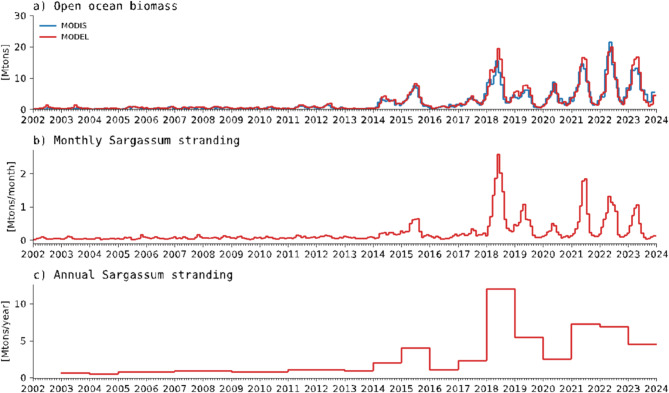
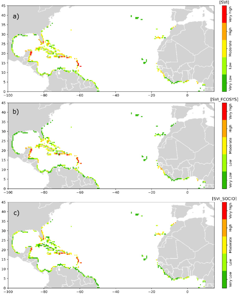
The proliferation of holopelagic Sargassum spp. (Sargassum) in the tropical North Atlantic Ocean is of concern for populations and coastal ecosystems in the Caribbean Sea, Gulf of Mexico, and West Africa. Satellite detections have enabled rough assessments of the quantity of algae that drifts seasonally in the open ocean, with seasonal peaks of Sargassum biomass reaching 10 to 20 million tons since 2018. Although the impacts on the coast have been widely publicized, there are no estimates of the quantities of Sargassum that accumulate on the coasts. This study proposes novel vulnerability indicators that combine information on Sargassum stranded biomass, ecosystem and socioeconomic factors to assess risks posed by Sargassum on coastal regions. Quantities of Sargassum that accumulate in the coastal strip at the regional scale were derived by combining the satellite detections in the open ocean with an algal growth-transport-stranding model. It shows that the amount of Sargassum accumulating on the Atlantic coast is of the order of 10% of the biomass estimated offshore and has accumulated between 2 and 10 million tons per year over the last five years. Vulnerability indices identify the Mexican Caribbean, northern Lesser Antilles, and eastern Great Antilles as the most vulnerable regions, facing significant ecosystemic and socioeconomic pressures from Sargassum influxes.
© 2025. The Author(s).
Conflict of interest statement
Declarations. Competing interests: The authors declare no competing interests.
Figures


References
-
- Gower, J., Young, E. & King, S. Satellite images suggest a new Sargassum source region in 2011. Remote Sens. Lett.4, 764–773 (2013).
-
- Wang, M. et al. The great Atlantic sargassum belt. Science365, 83–87 (2019). - PubMed
-
- Johns, E. M. et al. The establishment of a pelagic Sargassum population in the tropical Atlantic: biological consequences of a basin-scale long distance dispersal event. Prog Oceanogr.182, 102269 (2020).
-
- Jouanno, J., Berthet, S., Muller-Karger, F., Aumont, O. & Sheinbaum, J. An extreme North Atlantic Oscillation event drove the pelagic sargassum tipping point. Commun. Earth Environ.6, 95 (2025).
-
- United Nations Environment Programme- Caribbean Environment Programme (UNEP-CEP). Sargassum white Paper – Turning the crisis into an opportunity. Ninth Meeting of the Scientific and Technical Advisory Committee (STAC) To the Protocol Concerning Specially Protected Areas and Wildlife (SPAW) in the Wider Caribbean Region, Kingston, Jamaica (2021).
MeSH terms
LinkOut - more resources
Full Text Sources
Miscellaneous
