

Value Realization of Grassland Ecosystem Products in the Karst Desertification Control Area: Spatial Variability, Drivers, and Decision-Making
- PMID: 40170812
- PMCID: PMC11949571
- DOI: 10.1002/ece3.71168
Value Realization of Grassland Ecosystem Products in the Karst Desertification Control Area: Spatial Variability, Drivers, and Decision-Making
Erratum in
-
Correction to "Value Realization of Grassland Ecosystem Products in the Karst Desertification Control Area: Spatial Variability, Drivers, and Decision-Making".Ecol Evol. 2025 Apr 21;15(4):e71296. doi: 10.1002/ece3.71296. eCollection 2025 Apr. Ecol Evol. 2025. PMID: 40264842 Free PMC article.
Abstract
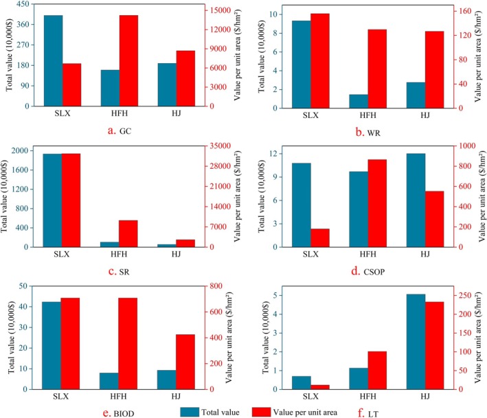
Transforming the ecological advantages of grassland ecosystems into economic benefits while ensuring their long-term health is an urgent but challenging question, particularly in karst areas characterized by significant spatial heterogeneity. This study selected three representative karst desertification control (KDC) areas within the South China Karst (SCK) as the research focus. Utilizing the quantified values of ecosystem products and their realization rates, we applied a random forest model to analyze the influencing factors. We found that: (1) The gross ecosystem products (GEP) of grassland per unit area increase with the severity of karst desertification. Conversely, the value realization rate decreases as the grade of karst desertification increases, contradicting the theoretical assumption that higher GEP correlates with a high value realization rate. (2) Water, soil, climate, and bare rock coupled with human activities (e.g., ecological engineering) affect the structure of the grassland GEP, which, in turn, affects the value realization rate of grassland ecosystem products in the KDC area. Based on our findings, we suggest that economic leapfrogging can be achieved through artificial grassland engineering in ecologically disadvantaged areas, challenging the conventional belief that a more fragile ecological environment results in poorer economic advantages. However, it is important to note that plant species diversity in artificial grassland in areas with severe karst desertification is low, and the trade-off and equity between ecology and economy must be carefully considered in future planning. Our findings can serve as a reference for subsequent phases of grassland ecosystem restoration for sustainability in ecologically fragile areas, particularly within the KDC regions.
Keywords: InVEST model; grassland; karst desertification control; random forest model; value realization of ecosystem products.
© 2025 The Author(s). Ecology and Evolution published by John Wiley & Sons Ltd.
Conflict of interest statement
The authors declare no conflicts of interest.
Figures


Similar articles
-
Improving grassland ecosystem services for human wellbeing in the karst desertification control area: Anthropogenic factors become more important.Sci Total Environ. 2024 Oct 10;946:174199. doi: 10.1016/j.scitotenv.2024.174199. Epub 2024 Jun 24. Sci Total Environ. 2024. PMID: 38925385
-
Research Advancement in Grassland Ecosystem Vulnerability and Ecological Resilience and Its Inspiration for Improving Grassland Ecosystem Services in the Karst Desertification Control.Plants (Basel). 2022 May 11;11(10):1290. doi: 10.3390/plants11101290. Plants (Basel). 2022. PMID: 35631715 Free PMC article. Review.
-
Eco-products value realization and eco-industry design of afforestation in the Karst Desertification Control.PLoS One. 2025 Apr 28;20(4):e0321541. doi: 10.1371/journal.pone.0321541. eCollection 2025. PLoS One. 2025. PMID: 40294032 Free PMC article.
-
Research Progress of Grassland Ecosystem Structure and Stability and Inspiration for Improving Its Service Capacity in the Karst Desertification Control.Plants (Basel). 2023 Feb 8;12(4):770. doi: 10.3390/plants12040770. Plants (Basel). 2023. PMID: 36840118 Free PMC article. Review.
-
Ecological stoichiometric characteristics of soil-moss C, N, and P in restoration stages of karst rocky desertification.PLoS One. 2021 Jun 30;16(6):e0252838. doi: 10.1371/journal.pone.0252838. eCollection 2021. PLoS One. 2021. PMID: 34191821 Free PMC article.
References
-
- Bardgett, R. D. , Bullock J. M., Lavorel S., et al. 2021. “Combatting Global Grassland Degradation.” Nature Reviews Earth and Environment 2, no. 10: 720–735. 10.1038/s43017-021-00207-2. - DOI
-
- Bartold, M. , and Kluczek M.. 2023. “A Machine Learning Approach for Mapping Chlorophyll Fluorescence at Inland Wetlands.” Remote Sensing 2023, no. 15: 2392. 10.3390/rs15092392. - DOI
-
- Bartold, M. , and Kluczek M.. 2024. “Estimating of Chlorophyll Fluorescence Parameter Fv/Fm for Plant Stress Detection at Peatlands Under Ramsar Convention With Sentinel‐2 Satellite Imagery.” Ecological Informatics 81: 102603. 10.1016/j.ecoinf.2024.102603. - DOI
Associated data
LinkOut - more resources
Full Text Sources
