[Preprint]. 2025 Mar 27:2025.03.24.645003.
doi: 10.1101/2025.03.24.645003.

Comparative performance of novel viral landscape phylogeography approaches

Affiliations

Comparative performance of novel viral landscape phylogeography approaches

Simon Dellicour et al. bioRxiv. .

Update in

Abstract

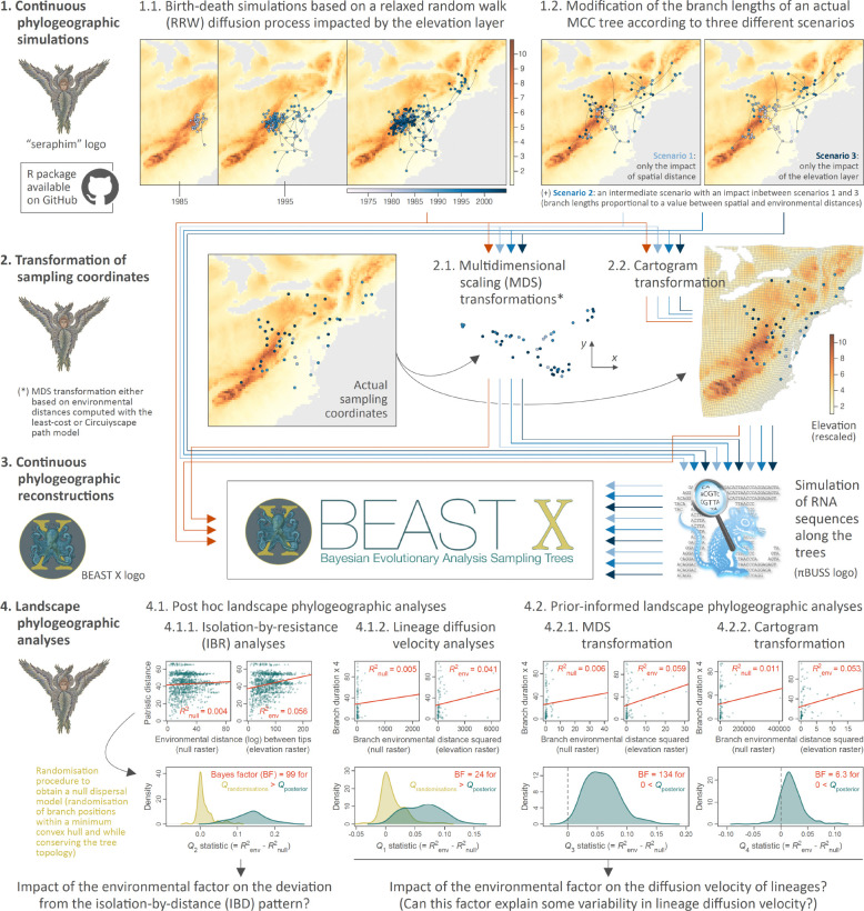
The fast rate of evolution in RNA viruses implies that their evolutionary and ecological processes occur on the same time scale. Genome sequences of these pathogens can therefore contain information about the processes that govern their transmission and dispersal. In particular, landscape phylogeographic approaches use phylogeographic reconstructions to investigate the impact of environmental factors and variables on the spatial spread of viruses. Here, we extend and improve existing approaches and develop three novel landscape phylogeographic methods that can test the impact of continuous environmental factors on the diffusion velocity of viral lineages. In order to evaluate the different methods, we also implemented two simulation frameworks to test and compare their statistical performance. The results enable us to formulate clear guidelines for the use of three complementary landscape phylogeographic approaches that have sufficient statistical power and low rates of false positives. Our open-source methods are available to the scientific community and can be used to investigate the drivers of viral spread, with potential benefits for understanding virus epidemiology and designing tailored intervention strategies.

Keywords: continuous phylogeography; landscape phylogeography; molecular epidemiology; viruses.


Figures

Figure 1.
Figure 1.. Illustration of a cartogram and multidimensional scaling (MDS) transformations based on an environmental layer tested as a potential resistance factor slowing the diffusion velocity of viral lineages.
We first display the cartogram transformation (B) of an original elevation raster (A; here rescaled from 1 to 11) along with the sampling coordinates (black dots) of the raccoon rabies virus (RABV) dataset sampled in northeastern USA (38). We then also display a MDS transformation of those coordinates based on environmental distances computed with the Circuitscape algorithm among all pairs of sampling points while treating the elevation raster as a resistance factor. In this third panel, sampling points are coloured according to the altitude of their position prior to the transformation of the space. As shown in panel B, the cartogram transformation of this elevation raster — here also tested as a potential resistance factor — tends to increase the relative distance between sampling points located in higher altitude areas while decreasing the relative distance between sampling points located in lower altitude areas. As shown in panel C, a similar observation can be made when visually inspecting the relative distance among sampling points before and after the MDS transformation: sampling points in relatively low altitude areas tend to be closer to each other after the MDS transformation. The rationale behind these two prior-informed landscape phylogeographic approaches based on a transformation of the study space (with a cartogram transformation or with a multidimensional scaling analysis) is to assess if such a transformation would lead to a more Brownian diffusion process than in the untransformed study space, which would then indicate an association between the tested environmental factor and the diffusion velocity of viral lineages.
Figure 2.
Figure 2.. Example of continuous phylogeographic simulations based on a birth-death process and a relaxed random walk (RRW) diffusion process during which an environmental layer impacts the diffusion velocity of viral lineages.
The two first panels display the phylogenetic tree obtained from a first simulation: (A) the timescaled visualisation of the simulated topology and (B) the mapped visualisation on the environmental layer impacting the movement velocity of evolving lineages — here an elevation raster rescaled from 1 to 11 (see the Materials and Methods section for further detail) and acting as a resistance factor (i.e. slowing down movement velocity in relatively higher altitude areas). The third panel (C) displays the mapped visualisation of a second example of simulation. In all panels, tree nodes are coloured according to time, with internal and tip nodes coloured according to their age and collection time, respectively. The RRW simulation process illustrated here is inspired by the phylogeographic analysis of the raccoon rabies virus spread in North America (13, 30, 38) and has been used in the present study to assess the statistical performance of four landscape phylogeographic approaches aiming at testing the impact of environmental factors on the diffusion velocity of viral lineages.
Figure 3.
Figure 3.. Simulation and analytical workflow implemented to assess the statistical performance of four landscape phylogeographic approaches to test the impact of environmental factors on the diffusion velocity of viral lineages or the deviation from an isolation-by-distance pattern.
We here assessed the performance of two post hoc (isolation-by-resistance and lineage diffusion velocity analyses) and two prior-informed landscape phylogeographic approaches (analyses of continuous phylogeographic reconstructions based on sampling coordinates obtained either after a multidimensional scaling or cartogram transformation). Continuous phylogeographic simulations (step 1), transformations of sampling coordinates (step 2), and landscape phylogeographic analyses were conducted with the R package “seraphim” (41), the RNA sequences simulations with the program πBUSS (42), and the continuous phylogeographic reconstructions (step 3) with the software package BEAST X version 1.10.5 (19). (*) Multidimensional scaling (MDS) transformations were conducted based on environmental distances among pair of tip nodes, which were computed using either the least-cost (5) or Circuitscape (3, 32) path model while either considering the environmental raster (here an elevation raster with values rescaled between one and eleven) or a corresponding “null” raster with accessible raster cell values uniformly equal to “1” (see the text for further detail). “MCC tree” refers to a maximum clade credibility tree.

References

    1. Manel S., Schwartz M. K., Luikart G., Taberlet P., Landscape genetics: Combining landscape ecology and population genetics. Trends Ecol. Evol. 18, 189–197 (2003).
    1. Balkenhol N., Waits L. P., Dezzani R. J., Statistical approaches in landscape genetics: An evaluation of methods for linking landscape and genetic data. Ecography 32, 818–830 (2009).
    1. McRae B. H., Isolation by resistance. Evolution 60, 1551–1561 (2006). - PubMed
    1. Manel S., Holderegger R., Ten years of landscape genetics. Trends Ecol. Evol. 28, 614–621 (2013). - PubMed
    1. Dijkstra E. W., A note on two problems in connexion with graphs. Numer. Math. 1, 269–271 (1959).

Publication types

LinkOut - more resources