

Nature-based Solutions as Building Blocks for coastal flood risk reduction: a model-based ecosystem service assessment
- PMID: 40199899
- PMCID: PMC11978945
- DOI: 10.1038/s41598-025-95230-4
Nature-based Solutions as Building Blocks for coastal flood risk reduction: a model-based ecosystem service assessment
Abstract
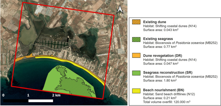
Nature-based Solutions (NbS) are increasingly recognized as effective measures for mitigating flood risks and enhancing climate change adaptation. However, evaluating their efficacy in delivering flood risk reduction ecosystem service (FRR-ESS) is usually limited by reliance on qualitative, expert-based "quick-scan" scoring methods. While already challenging for present-day evaluations, this limitation becomes even more significant when addressing future climate scenarios, introducing deep uncertainties in the evaluation. The present study introduces a model-based framework to quantify FRR-ESS provided by coastal NbS, which integrates expert-based assessments with quantitative results from an eco-hydro-morphodynamic numerical model. The model enables a comparative evaluation of individual and combined effects of NbS following a Building Blocks approach. By integrating habitat map change prediction in the evaluation, NbS flood reduction response to present and future storm scenarios (i.e. wave climate and sea level rise) are investigated. The methodology is applied to a Mediterranean coastal lagoon in Sicily (Italy), and can be easily adapted to diverse coastal ecosystems. Our findings underscore the significant role of coastal habitats in reducing flood risk and highlight the importance of integrating physically-based modelling into FRR-ESS evaluation. This approach provides a robust and flexible tool for policymakers and stakeholders to make informed decisions that support both ecological sustainability and disaster risk reduction.
© 2025. The Author(s).
Conflict of interest statement
Declarations. Competing interest: The authors declare no competing interests.
Figures


References
-
- Van Slobbe, E. et al. Building with nature: In search of resilient storm surge protection strategies. Nat. Hazards66, 1461–1480 (2013).
-
- Bryant, D. B., Bryant, M. A., Sharp, J. A., Bell, G. L. & Moore, C. The response of vegetated dunes to wave attack. Coast. Eng.152, 103506 (2019).
-
- Feagin, R. et al. The role of beach and sand dune vegetation in mediating wave run up erosion. Estuar. Coast. Shelf Sci.219, 97–106 (2019).
-
- Grases, A., Gracia, V., García-León, M., Lin-Ye, J. & Sierra, J. P. Coastal flooding and erosion under a changing climate: Implications at a low-lying coast (ebro delta). Water12, 346 (2020).
-
- Sánchez-Artús, X. et al. Evaluating barrier beach protection with numerical modelling. A practical case. Coast. Eng.191, 104522 (2024).
Grants and funding
- H2020-LC-GD-2020; Proposal no. 101037097/EC | Horizon 2020 Framework Programme (EU Framework Programme for Research and Innovation H2020)
- H2020-LC-GD-2020; Proposal no. 101037097/EC | Horizon 2020 Framework Programme (EU Framework Programme for Research and Innovation H2020)
- H2020-LC-GD-2020; Proposal no. 101037097/EC | Horizon 2020 Framework Programme (EU Framework Programme for Research and Innovation H2020)
- H2020-LC-GD-2020; Proposal no. 101037097/EC | Horizon 2020 Framework Programme (EU Framework Programme for Research and Innovation H2020)
- H2020-LC-GD-2020; Proposal no. 101037097/EC | Horizon 2020 Framework Programme (EU Framework Programme for Research and Innovation H2020)
LinkOut - more resources
Full Text Sources
Research Materials
Miscellaneous
