

Floristic Inventory and Diversity of Urban Green Spaces in the Municipality of Assemini (Sardinia, Italy)
- PMID: 40219171
- PMCID: PMC11991398
- DOI: 10.3390/plants14071102
Floristic Inventory and Diversity of Urban Green Spaces in the Municipality of Assemini (Sardinia, Italy)
Abstract
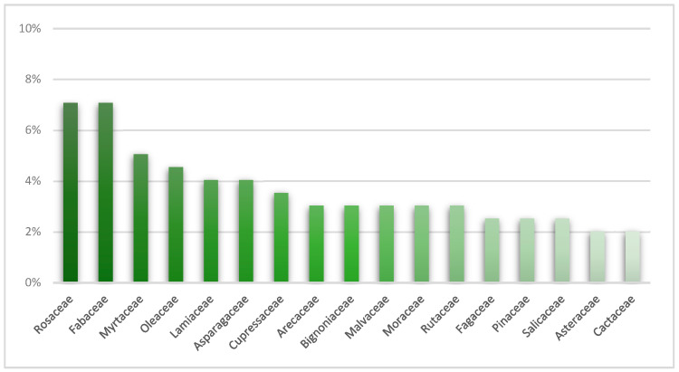
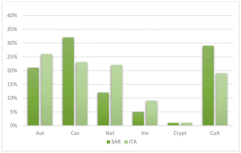
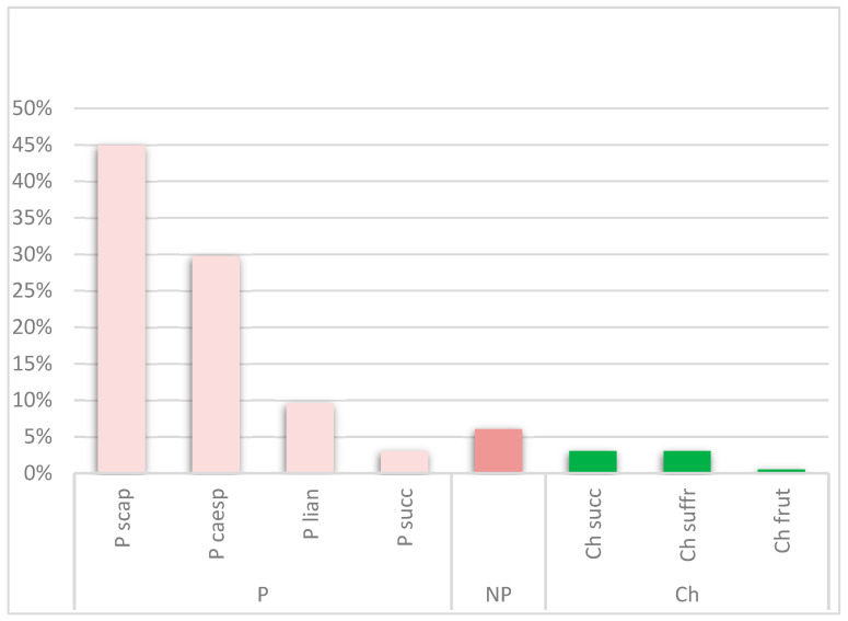
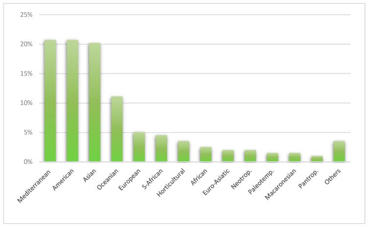
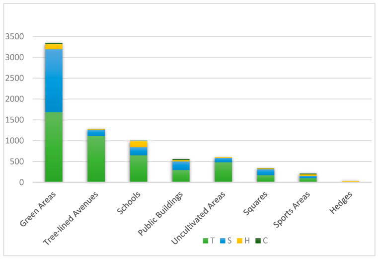
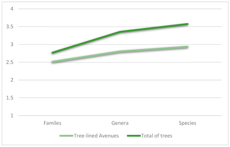
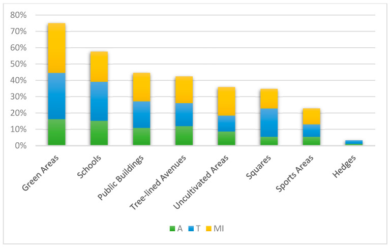
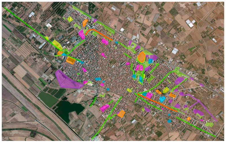
Urban greenery is a key component of green infrastructure, contributing to environmental sustainability and urban well-being. Between 2019 and 2020, a comprehensive inventory of ornamental flora was conducted in Assemini (Sardinia, Italy), documenting 198 vascular plant taxa, including 155 exotic, 41 native, and 2 cryptogenic species from 65 families. Among the exotic species, most were neophytes (63%), and 14% were archaeophytes. In terms of life forms, scapose phanerophytes, with a tree-like growth habit, dominated (45%), while Mediterranean and American chorotypes were the most represented, each accounting for 21%. A total of 7356 plants were recorded, comprising trees (61.3%), shrubs (32.3%), and climbers (5.7%), belonging to 90 shrub, 89 tree, and 19 climber taxa. The highest number of plants was found in "Green Areas" and "Schools", which also exhibited the greatest biodiversity, with 136 different taxa each. The most planted species were Quercus ilex, Nerium oleander, and Olea europaea. The survey also identified 21 allergenic, 36 toxic, and 35 mechanically harmful species, primarily located in "Green Areas" and "Schools". Biodiversity analysis using the Shannon Index revealed significant diversity, with Fabaceae, Apocynaceae, and Fagaceae emerging as the most represented families. These findings highlight the importance of plant inventories in urban green space management for sustainable planning. Well-maintained green spaces can enhance ecological resilience, improve public health, and promote social cohesion in future urban developments.
Keywords: biodiversity; green cities; invasive species; inventory ornamental plants; public green; sustainability.
Conflict of interest statement
The authors declare no conflicts of interest.
Figures
Similar articles
-
A Checklist of the Ornamental Vascular Flora of Sicily.Plants (Basel). 2025 Mar 4;14(5):795. doi: 10.3390/plants14050795. Plants (Basel). 2025. PMID: 40094722 Free PMC article.
-
A dataset of the flowering plants (Angiospermae) in urban green areas in five European cities.Data Brief. 2021 Jun 25;37:107243. doi: 10.1016/j.dib.2021.107243. eCollection 2021 Aug. Data Brief. 2021. PMID: 34307807 Free PMC article.
-
Estimation of the Allergenic Potential of Urban Trees and Urban Parks: Towards the Healthy Design of Urban Green Spaces of the Future.Int J Environ Res Public Health. 2019 Apr 15;16(8):1357. doi: 10.3390/ijerph16081357. Int J Environ Res Public Health. 2019. PMID: 30991765 Free PMC article.
-
Should we see urban trees as effective solutions to reduce increasing ozone levels in cities?Environ Pollut. 2018 Dec;243(Pt A):163-176. doi: 10.1016/j.envpol.2018.08.049. Epub 2018 Aug 20. Environ Pollut. 2018. PMID: 30172122 Review.
-
A comprehensive review of the environmental benefits of urban green spaces.Environ Res. 2024 Jul 1;252(Pt 2):118837. doi: 10.1016/j.envres.2024.118837. Epub 2024 Apr 1. Environ Res. 2024. PMID: 38570129 Review.
References
-
- F.A.O . Guidelines on Urban and Peri-Urban Forestry. Volume 178 Food and Agriculture Organization of the United Nations; Rome, Italy: 2016. FAO Forestry Paper.
-
- Atelli M., Blasi C., Boldini G., Cignini B., Cosenza G., Emiliani V., Villari P. Strategia Nazionale del Verde Urbano. Foreste Urbane Resilienti ed Eterogenee per la Salute e il Benessere Dei Cittadini. MATTM; Rome, Italy: 2018.
-
- Mehhdi R., Johari M.Y., Afshin S. Terminology of urban open and green spaces; Proceedings of the 11th ASEAN Postgraduate Seminar, Faculty of Built Environment, University of Malaysia; Kuala Lumpur, Malaysia. 15 November 2017.
-
- ISTAT Indicatori Ambientali Urbani. [(accessed on 10 September 2024)]. Available online: https://www.istat.it.
-
- E.C . Communication from the European Parliament, the Council, the European Economic and Social Committee and the Committee of the Regions. EC; Brussels, Belgium: 2020. EU Biodiversity Strategy for 2030 Bringing Nature Back into Our Lives.
LinkOut - more resources
Full Text Sources
