. 2025 May 7;15(1):15912.
doi: 10.1038/s41598-025-00795-9.

Badland distribution as a marker of rapid tectonic activity

Affiliations

Badland distribution as a marker of rapid tectonic activity

Ci-Jian Yang et al. Sci Rep. .

Abstract

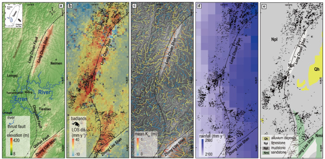
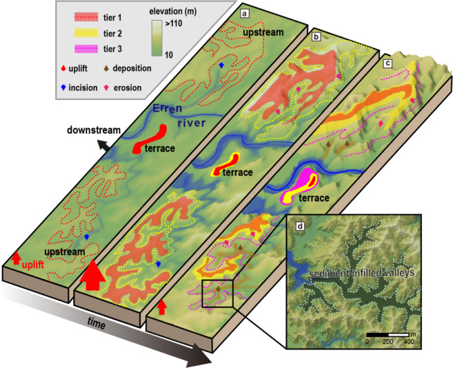
Tectonically driven processes, such as uplift and horizontal advection of rock mass, are important controls on landscape form and dynamics. Available fluvial topographic indicators are intended to be applied to slowly evolving systems over millennial time scales, which may prevent extracting short-term rapid tectonic effects (~ 1ky). Fast-eroding badlands provide an opportunity to study landscape response to uplift over short time scales. Here, using 1 m airborne LiDAR topographic data in the tectonically active area of southwestern Taiwan, we find that badlands occur within the most rapidly uplifting areas of the landscape, where uplift rates exceed 7 mm y- 1. Furthermore, badlands are predominantly observed within the altitude range that coincides with rapid uplift at 1.3-1.5 kyBP, implying that they formed in response to meso-scale (< 100 km2) rapid incision of tributaries. We demonstrate how the existing landscape-archive framework, connecting dimensionless erosion rate and relief for hillslopes, can be used on highly erodible badland morphology. As such, badlands can provide archives of uplift history for transient landscapes, which allows to target shorter timescales than previously possible.


Conflict of interest statement

Declarations. Competing interests: The authors declare no competing interests.

Figures

Fig. 1
Fig. 1
Study site and background information. (a) Color–shaded relief map showing the distribution of major faults. (b) InSAR results based on ALOS–1 data, showing the LOS displacement, which, shows spatial correlation with mapped badland area. (c) The normalized steepness index of channels (ksn, θ = 0.45) on a shaded relief map. (d) Grid–averaged annual rainfall map (2000–2010) (source: Central Weather Bureau, https://asrad.pccu.edu.tw/dbar/, last access: 5 May 2025). (e) Regional lithological map (source: Geological map of Taiwan scale 1:50,000, published by Geological Survey and Mining Management Agency, 2013, originally known as the Central Geological Survey, https://www.gsmma.gov.tw/nss/p/index, last access:  5 May 2025).
Fig. 2
Fig. 2
Correlation of hillslope gradient, LOS displacement, and the ratio of badlands area. (a) Correlation of LOS displacement and ratio of the badland area. (b) Correlation of gradient and ratio of the badland area. (c) Correlation of elevation (0–100 m) and the ratio of the badland area, KT1 denotes the position of a river terrace. The correlation coefficient is calculated at a significance level of 95%.
Fig. 3
Fig. 3
Schematic diagram of the development of mudstone badlands in response to uplift. The dashed line indicates the elevation of the badlands formed with the river terrace; the chronological sequence is distinguished by color. (a) Incision of the main stream (blue arrows) causes terrace formation. Lithologic weakness allows rapid upstream propagation of the incision signal. A first tier of steep slopes forms. (b) Rapidly increasing uplift causes tributary incision, which creates a second tier of steep barren slopes in the headwater regions (pink arrows). (c) Hillslope erosion prevails over decreasing uplift, thus forming sediment–infilled valleys (flat bottomed valley) on the toe of badlands (brown lines). (d) Color-shadow map of sediment–infilled valleys with 1 m spatial resolution.
Fig. 4
Fig. 4
Inferential evolution of hillslope morphology. (a) Bedrock incision rate over the 6 kyBP, the elevation and the inferred time are matched based on C terrace dating. (b) Sketch of parameterizations of badland hillslopes. (c) Variation in observed dimensionless erosion rate, E* (Eq. 3, obtained from elevation with respect to dated terraces) with elevation, with colours indicating the binned medians of dimensionless relief R* (Eq. 2). Error bars show the standard error of the mean for binned medians, and solid lines depict binned medians. The simple landscape evolution model (methods) yields modeled U (dashed grey line), calculated from Eq. (3), and modeled E* (dashed blue line). (d) Correlation of modeled E* and modeled U. Modeled U and modeled E* increase between 1 and 1.8 kyBP. Before 1.8 kyBP, uplift decreased, to which erosion showed a delayed response.

References

    1. Parker, R. et al. Mass wasting triggered by the 2008 Wenchuan earthquake is greater than orogenic growth. Nat. Geosci.4, 449–452 (2011).
    1. Willett, S. D. Orogeny and orography: the effects of erosion on the structure of mountain belts. J. Geophys. Res.104, 28957–28981 (1999).
    1. Sean, D. et al. Dynamic reorganization of river basins. Science343, 1248765 (2014). - PubMed
    1. Cattin, R. & Avouac, J. P. Modeling mountain Building and the seismic cycle in the himalaya of Nepal. J. Geophys. Res.105, 13389–13407 (2000).
    1. Howard, A. D. & Kerby, G. Channel changes in Badlands. Geol. Soc. Am. Bull.94, 739–752 (1983).

LinkOut - more resources