

Accessible Maps for the Future of Inclusive Ridesharing
- PMID: 40401304
- PMCID: PMC12093406
- DOI: 10.1145/3640792.3675736
Accessible Maps for the Future of Inclusive Ridesharing
Abstract
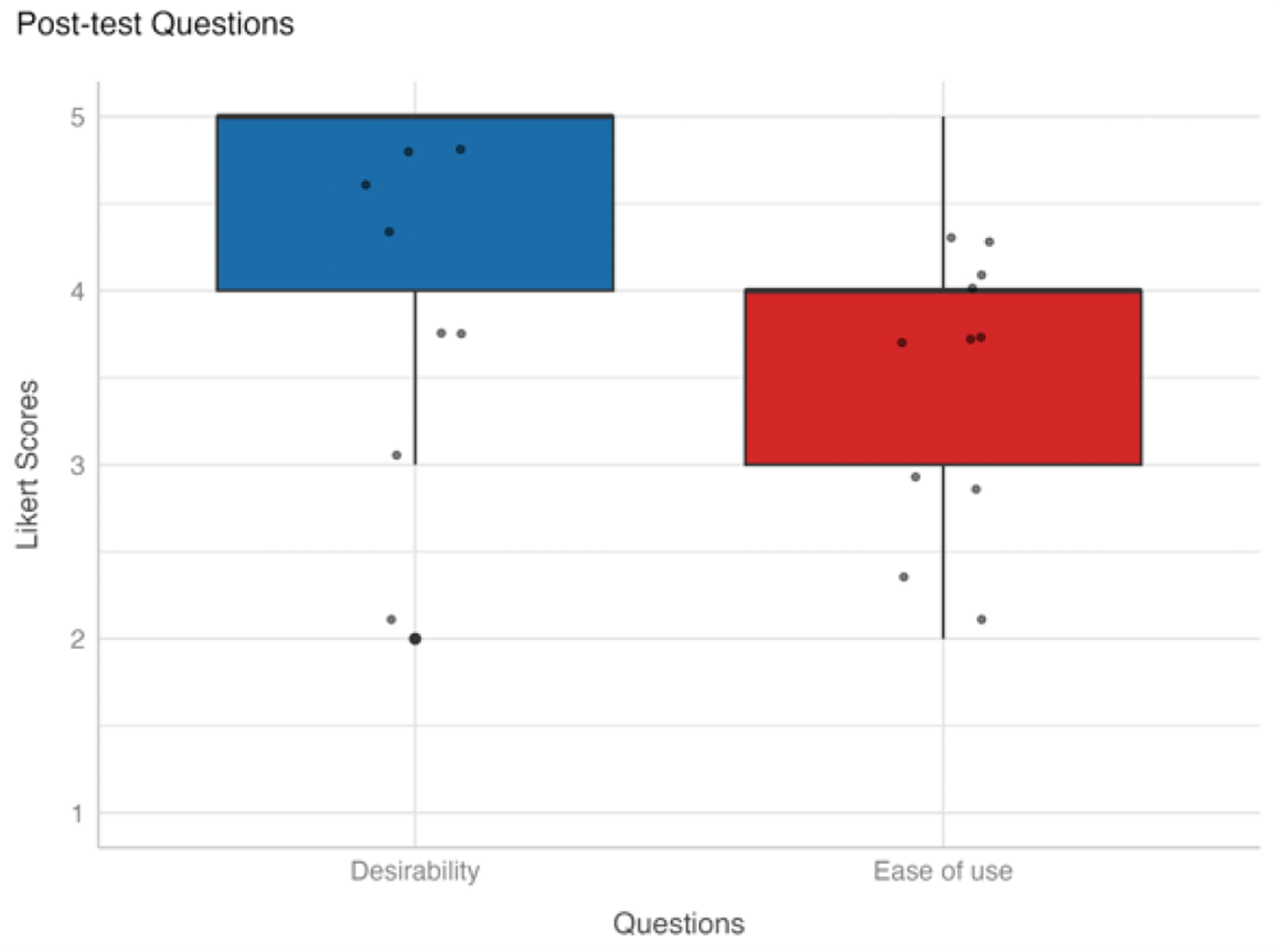
For people who are blind and low vision (BLV), ridesharing provides an important means of independence and mobility. However, a common challenge relates to finding the vehicle when it arrives to an unanticipated location. Although coordinating with the driver for assistance is serviceable in the near term, new solutions are necessary when a human is no longer available in future automated vehicles. Therefore, this paper presents and evaluates a multisensory smartphone-based map system designed to enable nonvisual tracking of summoned vehicles. Results from a user study with (N=12) BLV users suggest that vibro-audio maps (VAMs) promote superior spatial confidence and reasoning compared to current nonvisual audio interfaces in ridesharing apps, while also being desirable and easy to use. A subsequent expert evaluation based on improvements suggested during the user study indicate the practical utility of VAMs to address both current and future wayfinding challenges for BLV travelers.
Keywords: Accessibility; Blind and Low Vision Users; Haptic Interfaces; Maps; Ridesharing.
Figures


References
-
- Blades M, Ungar S and Spencer C 1999. Map Use by Adults with Visual Impairments. The Professional Geographer. 51, 4 (Nov. 1999), 539–553. DOI:10.1111/0033-0124.00191. - DOI
-
- Brewer RN, Austin AM and Ellison NB 2019. Stories from the Front Seat: Supporting Accessible Transportation in the Sharing Economy. Proceedings of the ACM on Human-Computer Interaction. 3, CSCW (Nov. 2019), 95:1–95:17. DOI:10.1145/3359197. - DOI
-
- Brewer RN and Ellison N 2020. Supporting People with Vision Impairments in Automated Vehicles: Challenge and Opportunities. University of Michigan, Ann Arbor, Transportation Research Institute, 2020. (2020).
-
- Brewer RN and Kameswaran V 2018. Understanding the Power of Control in Autonomous Vehicles for People with Vision Impairment. Proceedings of the 20th International ACM SIGACCESS Conference on Computers and Accessibility (New York, NY, USA, Oct. 2018), 185–197.
Grants and funding
LinkOut - more resources
Full Text Sources