

Introducing the dataset for measuring centrality for sustainability-A case study of Pecinci municipality, Serbia
- PMID: 40534919
- PMCID: PMC12173731
- DOI: 10.1016/j.dib.2025.111714
Introducing the dataset for measuring centrality for sustainability-A case study of Pecinci municipality, Serbia
Abstract
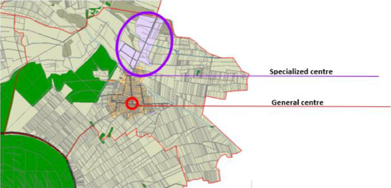
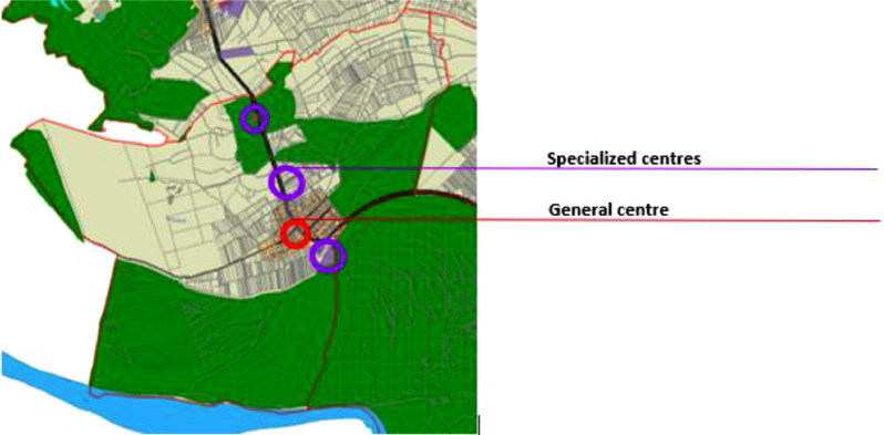
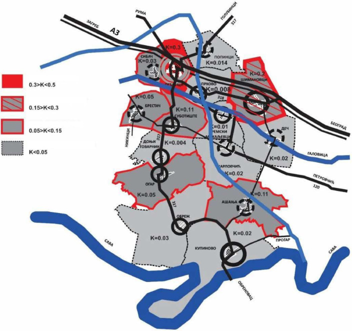
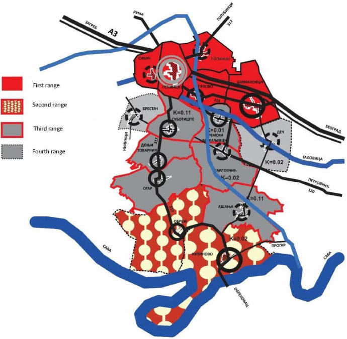
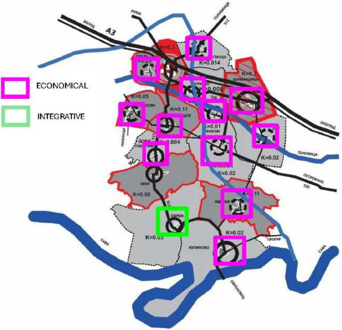
The paper presents a novel way of integrating data for sustainable planning of central activities at the spatial planning level. The method is demonstrated through a case study of the Plan of Central Activities for the Municipality of Pecinci, Serbia. The current theories and practices of planning central activities in Serbia primarily rely on functional factors of network flow. However, this approach aims to enhance the current practice of data utilisation for the sustainable development of central activities and integrative central places. This innovative approach considers a broader range of factors, such as economic vitality and social equity, to create a more comprehensive and holistic plan for central activities. By incorporating these additional dimensions into the planning process, the method offers a more sustainable and inclusive framework for future development in of central areas and their networks. It focuses on the morphological aspect of the distribution of centres, specifically their structure of local nodality, innovating qualitative and quantitative measures for their development, presenting statistics that categorise central places into three types: economic, social, and integrative. These categories are determined using a novel approach of data integration, which measures centrality as a major property of central places to meet Sustainability Development Goals - SDG and develop indicators for the goal 11 Make Cities and human Settlements Inclusive, Safe, Resilient and Sustainable. This approach allows for a comprehensive understanding of the role that central places play in fostering sustainable development within urban areas. By examining the economic, social, and integrative aspects of central places, we can better assess their impact on the overall well-being of communities. Additionally, by developing specific indicators for SDG 11, we can track progress towards creating inclusive, safe, resilient, and sustainable cities and human settlements. This research is crucial for informing policy decisions and urban planning efforts aimed at promoting sustainable development and improving quality of life for all residents. The data was obtained by using two open access sources: ecadastre, overseen by the Republic Geodetic Authority of Republic of Serbia, and the official cadastral base map, purchased for the purpose of performing this plan. Data gathering was done using online data sources and an official cadastral map. GIS was utilised to integrate alpha-numeric with spatial data at the cadastral lot unit. Alphanumeric values were gathered for each lot within 15 settlements of Municipality of Pecinci. The selection of alphanumeric data used land use criteria provided in ecadastre, specifically focusing on central activities such as industrial production, manufacturing, commercial offices, commerce, restaurants, cafes, cultural, government, and social services. Dataset presented in this article consists of analyzed data as follows: (1) Raw data on concentration in Municipality of Pećinci; (2) Formula for measuring centrality of general (community) and specialized centers, (3) Table 1: Criteria and indicators for defining the type of centrality, (4) Table 2. Type and level of centrality in settlement Asanja (example for economical centre), (5) Fig. 1. Distribution of general (community) and specialized centers in Asanja, (6) Table 3. Type and level of centrality in settlement Obrez (example for integrative centre), (7) Fig. 2. Distribution of general and specialized centers in Obrez, (8) Fi. 3. Assessment map 1 - Data on concentration in the Municipality of Pecinci, (9) Fig. 4. Assessment map 2 - Data on accessibility in the Municipality of Pecinci, (10) Fig. 5. Assessment map 3 - Data on the type of centrality in the Municipality of Pecinci. This paper provides a data framework for assessing centrality in urban areas, which can be applied to other regions facing similar challenges. The findings offer insights to inform policy decisions and planning strategies for promoting sustainable development in municipalities across Serbia and beyond. With the increasing urbanization and expansion of central activities in municipalities, understanding centrality is crucial for ensuring sustainable growth and development. By utilizing the framework presented in this study, policymakers, spatial and urban planners can make informed decisions, to prioritize the efficient allocation of resources and infrastructure to support central activities. This research contributes to the broader conversation on sustainable development and provides practical tools for implementing strategies that foster economic, social, and environmental well-being in territorial development.
Keywords: Centrality; Data integration; Integrated places; Spatial development.
© 2025 The Author(s).
Figures

Similar articles
-
Assessing the comparative effects of interventions in COPD: a tutorial on network meta-analysis for clinicians.Respir Res. 2024 Dec 21;25(1):438. doi: 10.1186/s12931-024-03056-x. Respir Res. 2024. PMID: 39709425 Free PMC article. Review.
-
Wood Waste Valorization and Classification Approaches: A systematic review.Open Res Eur. 2025 May 6;5:5. doi: 10.12688/openreseurope.18862.2. eCollection 2025. Open Res Eur. 2025. PMID: 40438563 Free PMC article.
-
Municipal solid waste management in Ethiopia - Physical and chemical compositions and generation rate: Systematic review.J Air Waste Manag Assoc. 2024 Dec;74(12):861-883. doi: 10.1080/10962247.2024.2416588. Epub 2024 Oct 29. J Air Waste Manag Assoc. 2024. PMID: 39441882
-
The impact of artisanal small-scale mining on environmental sustainability: implications for the attainment of the sustainable development goals (SDGs) in Ghana.Environ Sci Pollut Res Int. 2025 Jun;32(26):15546-15573. doi: 10.1007/s11356-025-36668-x. Epub 2025 Jun 25. Environ Sci Pollut Res Int. 2025. PMID: 40562999 Review.
-
Exploring engagement patterns within a mobile health intervention for women at risk of gestational diabetes.Womens Health (Lond). 2025 Jan-Dec;21:17455057251327510. doi: 10.1177/17455057251327510. Epub 2025 Jun 5. Womens Health (Lond). 2025. PMID: 40470610 Free PMC article. Clinical Trial.
References
-
- RGZ. (2022). Ecadastre of real estate. Retrieved from https://katastar.rgz.gov.rs/eKatastarPublic/PublicAccess.aspx
-
- Mrdjenovic T. Raw data on concentration in municipality of Pecinci, Serbia. Mendeley Data. 2025;1 doi: 10.17632/gfdrxrsjnc.1. - DOI
-
- Mrdjenovic T. Dataset on centrality in municipality of Pecinci, SERBIA. Mendeley Data. 2025;1 doi: 10.17632/kswg8ttxr2.1. - DOI
-
- Badovinac P. Arhitektonski fakultet Beograd; Beograd: 1981. Mikrolokacija u Urbanom Planiranju.
-
- Badovinac P. Arhitektonski fakultet Univerziteta u Beogradu; Beograd: 1997. Centralne Urbane Funkcije - CENTRI.
LinkOut - more resources
Full Text Sources
