Barystatic sea level change observed by satellite gravimetry: 1993-2022
- PMID: 40587797
- PMCID: PMC12260393
- DOI: 10.1073/pnas.2425248122
Barystatic sea level change observed by satellite gravimetry: 1993-2022
Abstract
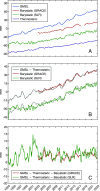
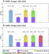
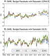
Using time-variable gravity fields determined from satellite laser ranging (SLR) and the Gravity Recovery and Climate Experiment (GRACE) and GRACE Follow-On (GRACE-FO), we derive three decades of barystatic sea level (BSL) change estimates since 1993, providing a long record of satellite gravimetry-based BSL estimates comparable in duration to satellite altimetry. Over the 1993-2022 altimetry era, the BSL change rate is 1.75 ± 0.59 mm/y (2σ) as observed by SLR. The rate increases to 2.16 ± 0.59 mm/y (SLR) and 2.13 ± 0.38 mm/y (GRACE/-FO) over 2003-2022, mainly due to accelerated ice loss in Greenland since the 2000s. The remarkable agreement between SLR and GRACE/-FO estimates over the joint period cross-validates each other, suggesting that both work well in monitoring BSL changes. We also compare our satellite gravimetry estimates with the sum of individual mass change components (ice sheets, glaciers, and land water storage) obtained from multisource datasets (in situ, remote sensing and geophysical modeling). The differences are within 0.2 mm/y over the three decades, highlighting the global consistency of different techniques for observing Earth's surface mass changes. Moreover, we reconcile the global mean sea level (GMSL) rise budget using reprocessed altimetry data and updated thermosteric sea level ensembles. From 1993 to 2022, the sum of thermosteric and SLR-based barystatic contributions (3.16 ± 0.64 mm/y) agrees well with altimetry-observed GMSL rate (3.22 ± 0.28 mm/y), suggesting that the GMSL rise budget can be closed within uncertainties over the last three decades.
Keywords: barystatic sea level change; climate change; satellite gravimetry; sea level budget.
Conflict of interest statement
Competing interests statement:The authors declare no competing interest.
Figures


Similar articles
-
Investigating the closures of sea level budgets in China's adjacent seas.Sci Rep. 2025 Jul 2;15(1):23224. doi: 10.1038/s41598-025-06214-3. Sci Rep. 2025. PMID: 40603422 Free PMC article.
-
Transcutaneous electrical nerve stimulation (TENS) for fibromyalgia in adults.Cochrane Database Syst Rev. 2017 Oct 9;10(10):CD012172. doi: 10.1002/14651858.CD012172.pub2. Cochrane Database Syst Rev. 2017. PMID: 28990665 Free PMC article.
-
Needle size for vaccination procedures in children and adolescents.Cochrane Database Syst Rev. 2015 Jun 18;(6):CD010720. doi: 10.1002/14651858.CD010720.pub2. Cochrane Database Syst Rev. 2015. Update in: Cochrane Database Syst Rev. 2018 Aug 09;8:CD010720. doi: 10.1002/14651858.CD010720.pub3. PMID: 26086647 Updated.
-
Oral morphine for cancer pain.Cochrane Database Syst Rev. 2016 Apr 22;4(4):CD003868. doi: 10.1002/14651858.CD003868.pub4. Cochrane Database Syst Rev. 2016. PMID: 27105021 Free PMC article.
-
Short-Term Memory Impairment.2024 Jun 8. In: StatPearls [Internet]. Treasure Island (FL): StatPearls Publishing; 2025 Jan–. 2024 Jun 8. In: StatPearls [Internet]. Treasure Island (FL): StatPearls Publishing; 2025 Jan–. PMID: 31424720 Free Books & Documents.
References
-
- Cazenave A., Palanisamy H., Ablain M., Contemporary sea level changes from satellite altimetry: What have we learned? What are the new challenges? Adv. Space. Res. 62, 1639–1653 (2018).
-
- Meyssignac B., et al. , How accurate is accurate enough for measuring sea-level rise and variability? Nat. Clim. Change 13, 796–803 (2023).
-
- Cheng L., et al. , Past and future ocean warming. Nat. Rev. Earth Environ. 3, 776–794 (2022).
-
- Horwath M., et al. , Global sea-level budget and ocean-mass budget, with a focus on advanced data products and uncertainty characterisation. Earth Syst. Sci. Data 14, 411–447 (2022).
Grants and funding
LinkOut - more resources
Full Text Sources

