

An integrated GIS-pXRF approach assesses ecological and human health risks from heavy metals in county level soils
- PMID: 40593040
- PMCID: PMC12217179
- DOI: 10.1038/s41598-025-05989-9
An integrated GIS-pXRF approach assesses ecological and human health risks from heavy metals in county level soils
Abstract
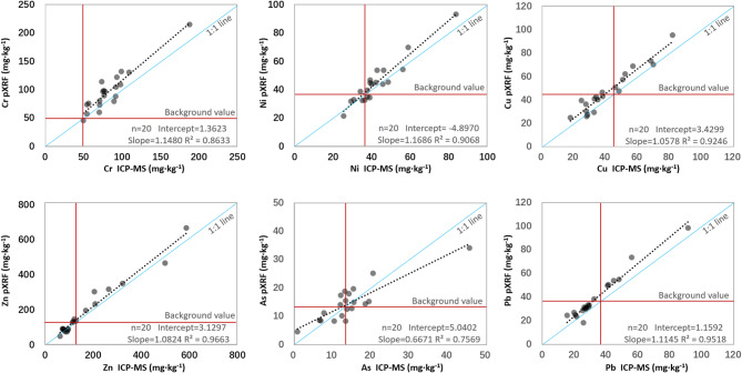
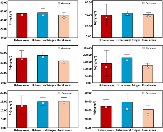
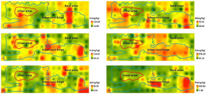
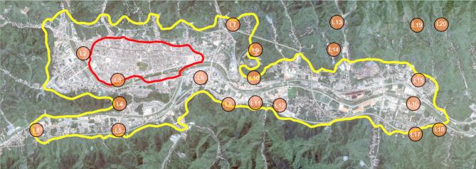
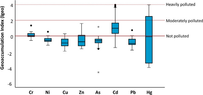
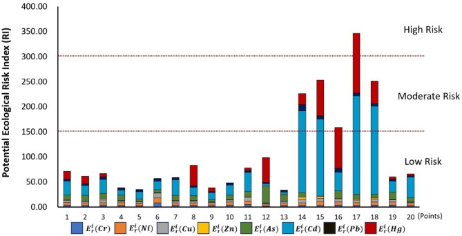
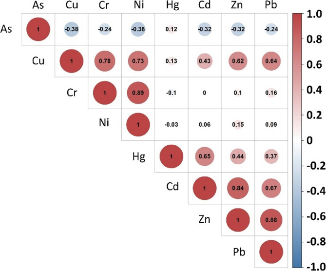
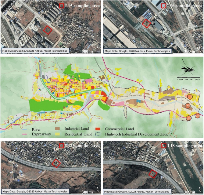
Counties in China are the primary components of small and mid-sized city (SMC), and at the core of China's future urbanization and industrialization development. Land is an essential nature resource providing the basis for urban-rural development, which is directly influenced by anthropogenic processes and in turn has impacts on human health. Clarifying the distribution characteristics and causes of heavy metals (HMs) pollution in soils is key to ensuring human health, as well as promoting land sustainability at county-level. In order to efficiently identify high risk regions of HMs pollution, this study proposed a geographic information system (GIS)-portable X-ray fluorescence (pXRF)-based approach to measure local soil background of HMs and to screen high risk regions in Shangzhou, China. ICP-MS and pXRF results showed a good agreement of Cr, Ni, Cu, Zn, Pb and As with R2 ranging from 0.757 to 0.966. Soil background of Ni, Cu, Zn, As and Pb had increased by 33.34-129.74% compared to 1990 levels. HMs concentrations in soils of urban-rural fringe were generally larger than those of urban and rural area. Particularly, soil background of Zn and Pb in urban-rural fringe exceeded 28.90% and 19.93% of urban area, 46.33% and 41.91% of rural area, respectively. In high soil background regions, 25% of sampling points were considered as moderate risk or above, with ecological risk index (RI) greater than 150. As, Cr and Ni were identified as major contributors to human health risk, and children were more vulnerable than adults with considerably total non-carcinogenic risk (THI = 1.46) and carcinogenic health risk (TCR = 1.52 × 10- 4). Anthropogenic process including industrial manufacturing, agricultural practice, urban expansion and land conversion brought about the HMs accumulation in soils. This study indicated industrial zone in urban-rural fringe should be priority-controlled, and provided scientific basis for urban-rural environmental management and human health risk protection.
Keywords: Heavy metal; Human health risk; Small and mid-sized City; Soil background; Urban-rural fringe.
© 2025. The Author(s).
Conflict of interest statement
Declarations. Competing interests: The authors declare no competing interests.
Figures
References
-
- United Nations Human Settlements Programme (UN-Habitat). World Cities Report 2022: Envisaging the Future of Cities. https://unhabitat.org/wcr/ (2022).
-
- National Bureau of Statistics of China. China Statistical Yearbook. https://www.stats.gov.cn/sj/ndsj/2022/indexch.htm (2022).
-
- Zhou, Y., Zhong, Z. & Cheng, G. Q. Cultivated land loss and construction land expansion in china: evidence from National land surveys in 1996, 2009 and 2019. Land. Use Policy. 125, 106496. 10.1016/j.landusepol.2022.106496 (2023). - DOI
-
- Liu, Y. S., Yang, R. & Lin, Y. C. Pattern evolution and optimal paths of County urbanization in China. Acta Geogr. Sin.77, 12, 2937–2953 (2022).
-
- Yan, Y., Liu, H., Wang, N. C. & Yao, S. J. How does low-density urbanization reduce the financial sustainability of Chinese cities? A debt perspective. Land10, 981. 10.3390/land10090981 (2021). - DOI
MeSH terms
Substances
Grants and funding
- 2024WHZ0237/Technology Innovation Center for Land Engineering and Human Settlements, Shaanxi Land Engineering Construction Group Co., Ltd and Xi'an Jiaotong University
- 2024WHZ0237/Technology Innovation Center for Land Engineering and Human Settlements, Shaanxi Land Engineering Construction Group Co., Ltd and Xi'an Jiaotong University
- 2024WHZ0237/Technology Innovation Center for Land Engineering and Human Settlements, Shaanxi Land Engineering Construction Group Co., Ltd and Xi'an Jiaotong University
- 2023-CX-RKX-102/Innovation Capability Support Program of Shaanxi Province, China
- 2023-CX-RKX-102/Innovation Capability Support Program of Shaanxi Province, China
- 2023-CX-RKX-102/Innovation Capability Support Program of Shaanxi Province, China
- 2024WZ-YBXM-19/Shaanxi Province Foreign Expert Service Project
- 300102352502/Open Fund of Shaanxi Key Laboratory of Land Consolidation, China
- DJNY-YB-2023-20/Project of Shaanxi Province Land Engineering Construction Group
- DJNY-YB-2023-20/Project of Shaanxi Province Land Engineering Construction Group
- 2024JC-YBQN-0541/Natural Science Basic Research Program of Shaanxi Province
LinkOut - more resources
Full Text Sources
Research Materials
