

Tidal bore revealed by SWOT: a case study from the Severn river
- PMID: 40593242
- PMCID: PMC12217661
- DOI: 10.1038/s41598-025-99597-2
Tidal bore revealed by SWOT: a case study from the Severn river
Abstract
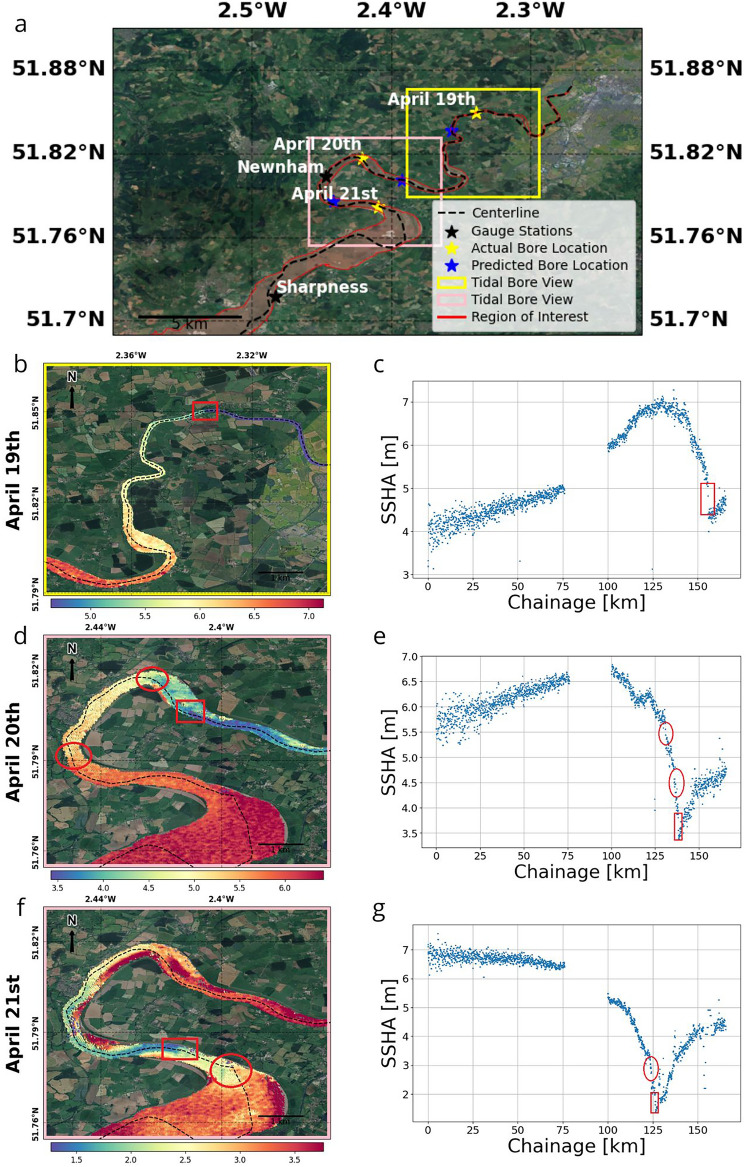
We utilize Surface Water and Ocean Topography (SWOT) satellite data to derive a complete longitudinal profile of water surface elevations for tidal waves and capture a tidal bore within the Bristol Channel and Severn River system, marking the first such observation from satellite data. We demonstrate that SWOT high-rate data is highly accurate, even in intertidal zones with significant wetting and drying and extreme tidal amplitude, emphasizing the importance of minimal data smoothing to preserve critical details. By examining the tidal bore and associated tidal waves over three days (April 19-21, 2023), we gain novel insights into tidal bore dynamics and tidal wave interactions with inland waters. SWOT's high-resolution altimetry data bridges the coastal knowledge gap, enabling unprecedented integration of hydrology and physical oceanography. Tidal bores are crucial for ecological processes and hold cultural significance globally. Despite ongoing research, many hydrodynamic aspects of tidal bores remain unresolved, and our findings enhance the understanding of these phenomena.
© 2025. The Author(s).
Figures

References
-
- Stammer, D. et al. Accuracy assessment of global barotropic ocean tide models. Rev. Geophys.52(3), 243–282. 10.1002/2014rg000450 (2014).
-
- Abdalla, S. et al. Altimetry for the future: Building on 25 years of progress. Adv. Sp. Res.68(2), 319–363. 10.1016/J.ASR.2021.01.022 (2021).
-
- Łyszkowicz, A. B. & Bernatowicz, A. Current state of art of satellite altimetry. Geod. Cartogr.66(2), 259–270. 10.1515/geocart-2017-0016 (2018).
-
- Vignudelli, S. et al. Satellite altimetry measurements of sea level in the coastal zone. Surv. Geophys.40, 1319–1349 (2019).
-
- Fernandes, M. J., Lázaro, C. & Vieira, T. On the role of the troposphere in satellite altimetry. Remote Sens. Environ.252, 112149 (2021).
LinkOut - more resources
Full Text Sources
Miscellaneous
