

Impact of LULC changes on small watershed morphometry and delineation of sustainable conservation strategies for degraded transboundary rivers
- PMID: 40617856
- PMCID: PMC12228773
- DOI: 10.1038/s41598-025-08841-2
Impact of LULC changes on small watershed morphometry and delineation of sustainable conservation strategies for degraded transboundary rivers
Abstract
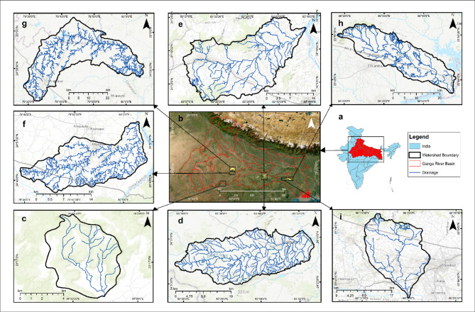
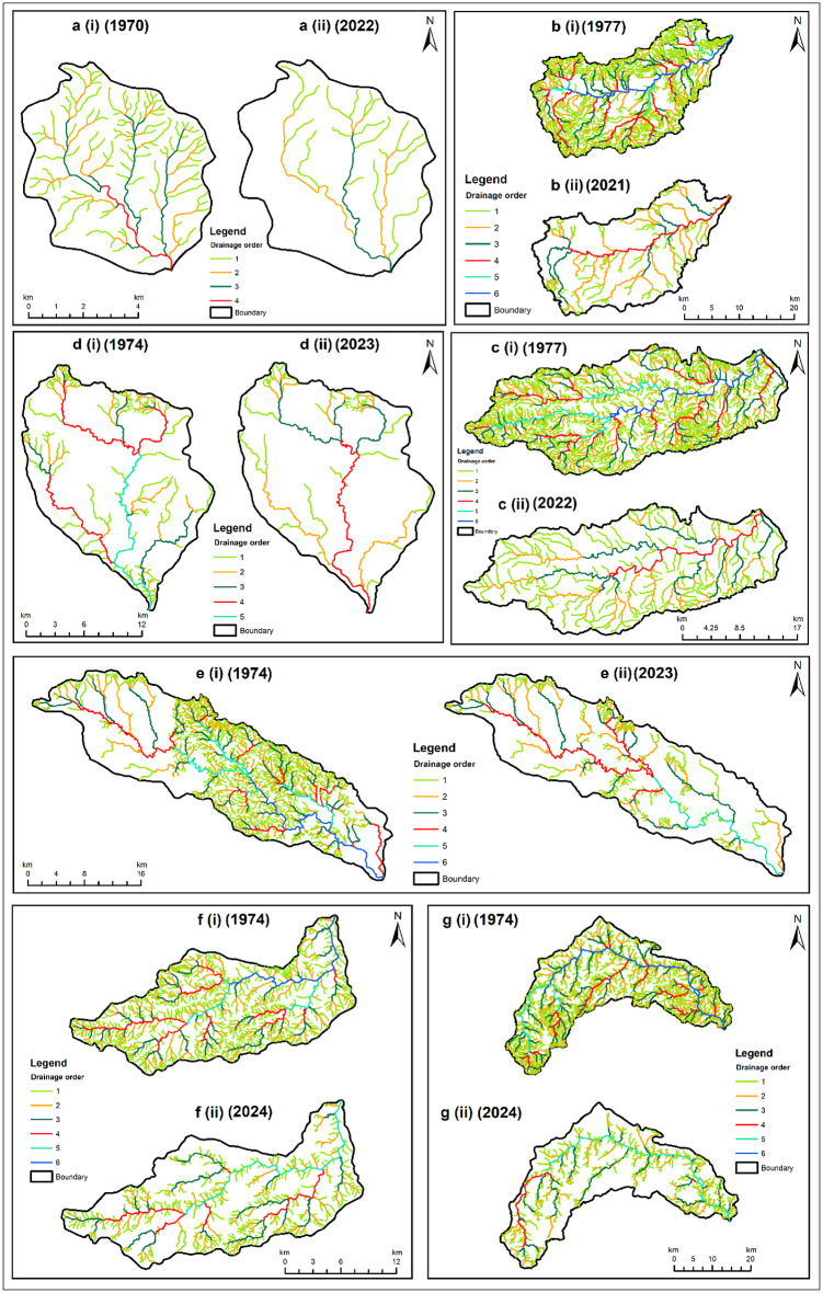
Small streams in the large river basins are disappearing, and there is no update on their historical and current morphometric status. Field inventory and visual inspections quantified the impact of land use and land cover (LULC) change on the reference year morphometry (1970-1977) of seven watersheds and fifty-six subwatersheds, using drone imagery and Global Positioning System-based ground control points to refine the reference map and generate the current map (2021-2024). The decreasing stream number (Nu), stream length (Lu), and drainage density (Dd) (1) explained the mechanism of disappearing and shrinking large rivers; (2) classified seven watersheds and fifty-six subwatersheds into near threatened (NT), vulnerable (VU), endangered (EN), critically endangered (CR), and extinct (EX) categories; and (3) emphasized rejuvenation of 9,84,068 km of lost streams to restore Dd ≥ 2 km/km2 in the Ganga River basin (GRB). From these empirical estimates, the UN's commitment to restoring 300,000 km of degraded rivers thus needs ~ 150,000 km2 of watershed area to delineate ex-situ and in-situ restoration and conservation of disappearing three intrinsic morphometric attributes, i.e., Nu, Lu, and Dd.
Keywords: Drainage density; Morphometry; RRLCC; Stream order; Water policy.
© 2025. The Author(s).
Conflict of interest statement
Declarations. Competing interests: The authors declare no competing interests.
Figures

References
-
- Director General of Archaeology in India. Archaeol. Surv. India Anc. India, 15–19, 45–46 (1959).
-
- Tvedt, T. & Coopey, R. A Water Systems perspective on History. Volume 2: Rivers and Society: from early civilizations to modern Times (2009).
-
- Macklin, M. G. & Lewin, J. The rivers of civilization. Quat Sci. Rev.114, 228–244 (2015).
-
- Bredenhand, E. & Samways, M. J. Impact of a dam on benthic macroinvertebrates in a small river in a biodiversity hotspot: cape floristic region, South Africa. J. Insect Conserv.13, 297–307 (2009).
Grants and funding
- IIT(ISM)/2021-22/826/INSTITUTE/Indian Institute of Technology (Indian School of Mines), Dhanbad
- IIT(ISM)/2021-22/826/INSTITUTE/Indian Institute of Technology (Indian School of Mines), Dhanbad
- IIT(ISM)/2021-22/826/INSTITUTE/Indian Institute of Technology (Indian School of Mines), Dhanbad
- IIT(ISM)/2021-22/826/INSTITUTE/Indian Institute of Technology (Indian School of Mines), Dhanbad
- A-33015/2/2022-P.I/MoEF&CC/Ministry of Environment, Forest and Climate Change
LinkOut - more resources
Full Text Sources
Research Materials
Miscellaneous
