

Utilizing GCN-Based Deep Learning for Road Extraction from Remote Sensing Images
- PMID: 40648174
- PMCID: PMC12251830
- DOI: 10.3390/s25133915
Utilizing GCN-Based Deep Learning for Road Extraction from Remote Sensing Images
Abstract
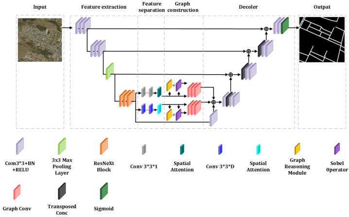
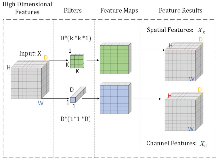
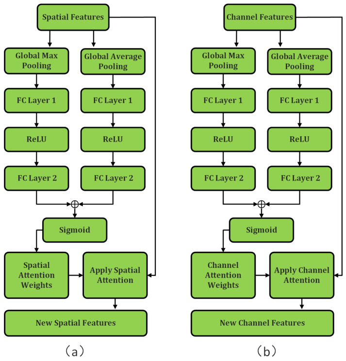
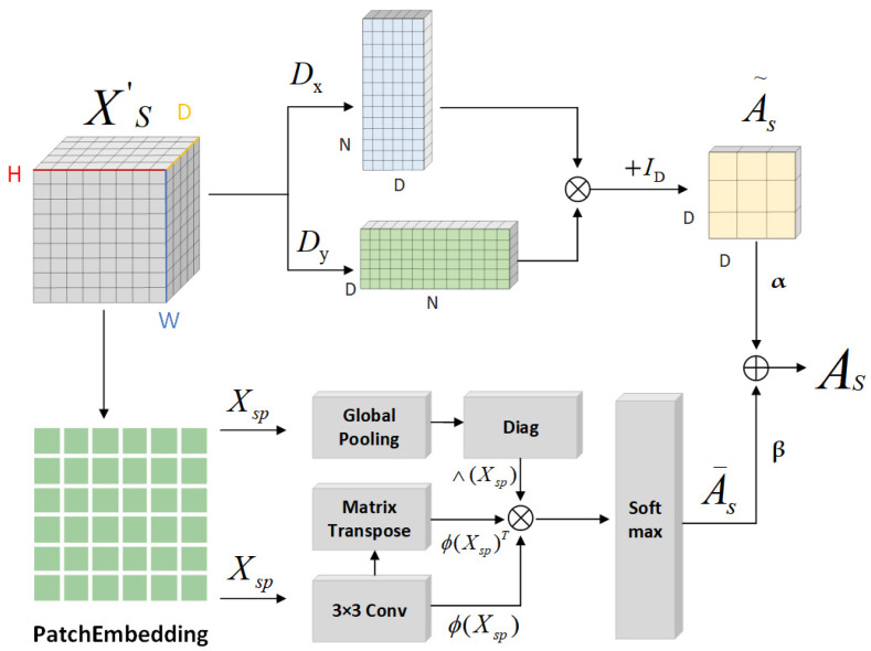
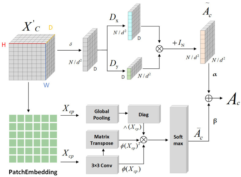
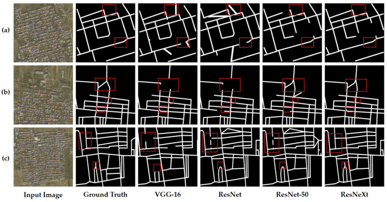
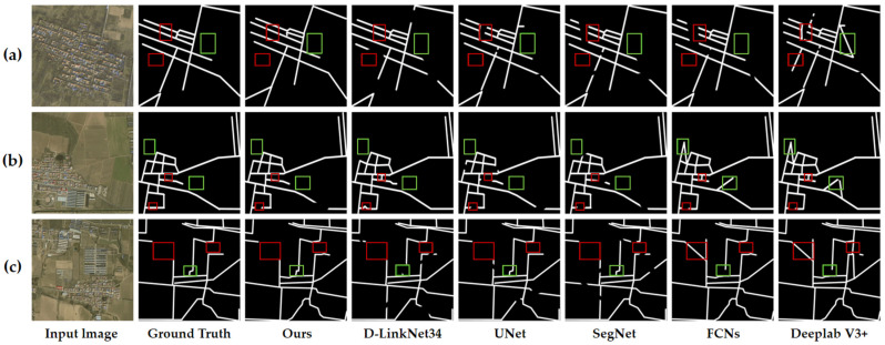
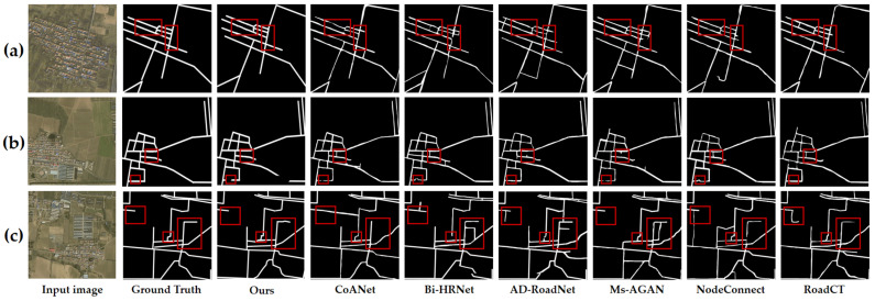
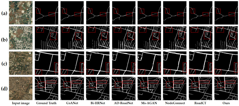
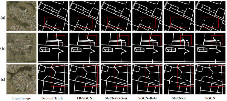
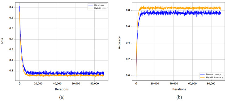
The technology of road extraction serves as a crucial foundation for urban intelligent renewal and green sustainable development. Its outcomes can optimize transportation network planning, reduce resource waste, and enhance urban resilience. Deep learning-based approaches have demonstrated outstanding performance in road extraction, particularly excelling in complex scenarios. However, extracting roads from remote sensing data remains challenging due to several factors that limit accuracy: (1) Roads often share similar visual features with the background, such as rooftops and parking lots, leading to ambiguous inter-class distinctions; (2) Roads in complex environments, such as those occluded by shadows or trees, are difficult to detect. To address these issues, this paper proposes an improved model based on Graph Convolutional Networks (GCNs), named FR-SGCN (Hierarchical Depth-wise Separable Graph Convolutional Network Incorporating Graph Reasoning and Attention Mechanisms). The model is designed to enhance the precision and robustness of road extraction through intelligent techniques, thereby supporting precise planning of green infrastructure. First, high-dimensional features are extracted using ResNeXt, whose grouped convolution structure balances parameter efficiency and feature representation capability, significantly enhancing the expressiveness of the data. These high-dimensional features are then segmented, and enhanced channel and spatial features are obtained via attention mechanisms, effectively mitigating background interference and intra-class ambiguity. Subsequently, a hybrid adjacency matrix construction method is proposed, based on gradient operators and graph reasoning. This method integrates similarity and gradient information and employs graph convolution to capture the global contextual relationships among features. To validate the effectiveness of FR-SGCN, we conducted comparative experiments using 12 different methods on both a self-built dataset and a public dataset. The proposed model achieved the highest F1 score on both datasets. Visualization results from the experiments demonstrate that the model effectively extracts occluded roads and reduces the risk of redundant construction caused by data errors during urban renewal. This provides reliable technical support for smart cities and sustainable development.
Keywords: depthwise separable convolution; gradient operator; graph convolution; graph reasoning; road extraction; smart cities.
Conflict of interest statement
The authors declare no conflicts of interest.
Figures
Similar articles
-
Short-Term Memory Impairment.2024 Jun 8. In: StatPearls [Internet]. Treasure Island (FL): StatPearls Publishing; 2025 Jan–. 2024 Jun 8. In: StatPearls [Internet]. Treasure Island (FL): StatPearls Publishing; 2025 Jan–. PMID: 31424720 Free Books & Documents.
-
Sexual Harassment and Prevention Training.2024 Mar 29. In: StatPearls [Internet]. Treasure Island (FL): StatPearls Publishing; 2025 Jan–. 2024 Mar 29. In: StatPearls [Internet]. Treasure Island (FL): StatPearls Publishing; 2025 Jan–. PMID: 36508513 Free Books & Documents.
-
Leveraging a foundation model zoo for cell similarity search in oncological microscopy across devices.Front Oncol. 2025 Jun 18;15:1480384. doi: 10.3389/fonc.2025.1480384. eCollection 2025. Front Oncol. 2025. PMID: 40606969 Free PMC article.
-
Management of urinary stones by experts in stone disease (ESD 2025).Arch Ital Urol Androl. 2025 Jun 30;97(2):14085. doi: 10.4081/aiua.2025.14085. Epub 2025 Jun 30. Arch Ital Urol Androl. 2025. PMID: 40583613 Review.
-
Systemic pharmacological treatments for chronic plaque psoriasis: a network meta-analysis.Cochrane Database Syst Rev. 2021 Apr 19;4(4):CD011535. doi: 10.1002/14651858.CD011535.pub4. Cochrane Database Syst Rev. 2021. Update in: Cochrane Database Syst Rev. 2022 May 23;5:CD011535. doi: 10.1002/14651858.CD011535.pub5. PMID: 33871055 Free PMC article. Updated.
References
-
- Bong D.B.L., Lai K.C., Joseph A.A. Automatic road network recognition and extraction for urban planning. World Acad. Sci. Eng. Technol. Int. J. Civil Environ. Struct. Construct. Archit. Eng. 2009;3:206–212.
-
- Manandhar P., Marpu P.R., Aung Z. Deep learning approach to update road network using VGI data; Proceedings of the 2018 International Conference on Signal Processing and Information Security (ICSPIS); Dubai, United Arab Emirates. 7–8 November 2018; pp. 1–4.
-
- Manandhar P., Marpu P.R., Aung Z., Melgani F. Towards automatic extraction and updating of VGI-based road networks using deep learning. Remote Sens. 2019;11:1012. doi: 10.3390/rs11091012. - DOI
-
- Chang C.-K., Siagian C., Itti L. Mobile robot vision navigation based on road segmentation and boundary extraction algorithms. J. Vis. 2012;12:200. doi: 10.1167/12.9.200. - DOI
-
- Ghaziani M., Mohamadi Y., Koku A.B. Extraction of unstructured roads from satellite images using binary image segmen-tation; Proceedings of the 2013 21st Signal Processing and Communications Applications Conference; Haspolat, Turkey. 24–26 April 2013; pp. 1–4.
Grants and funding
LinkOut - more resources
Full Text Sources
