. 2025 Jul 10;14(14):2130.
doi: 10.3390/plants14142130.

Enhancing Conservation Efforts in the Qinling Mountains Through Phenotypic Trait Diversity Optimization

Affiliations

Enhancing Conservation Efforts in the Qinling Mountains Through Phenotypic Trait Diversity Optimization

Sibo Chen et al. Plants (Basel). .

Abstract

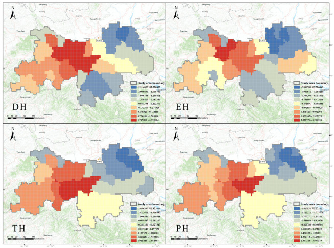
The establishment of conservation areas is considered one of the most effective approaches to address biodiversity loss with limited resources. Identifying hotspots of plant diversity and conservation gaps has played a crucial role in optimizing conservation areas. Utilizing diverse types of research data can effectively enhance the recognition of hotspots and conservation gaps. Phenotypic trait diversity is a functional biogeography that analyzes the geographic distribution patterns, formation, and reasons for the development of specific or multiple phenotypic traits of organisms. Flower color and fruit color phenotypic traits are primary characteristics through which plants interact with other organisms, affecting their own survival and reproduction, and that of their offspring. This study utilized data from 1923 Phenotypic Trait Diversity Species (PTDS) with flower and fruit color characteristics to optimize conservation areas in the Shaanxi Qinling Mountains. Additionally, data from 1838 endemic species (ES), 190 threatened species (TS), and 119 protected species (PS) were used for validation. The data were primarily sourced from the Catalogue of Vascular Plants in Shaanxi, supplemented by the Chinese Virtual Herbarium and the Shaanxi Digital Herbarium. The results reveal that by comparing the existing conservation area boundaries with those determined by four types of data, conservation gaps are found in 14 counties in the Qinling Mountains of Shaanxi. The existing conservation area only accounts for 13.3% of the area determined by the four types of data. There are gaps in biodiversity conservation in the Qinling Mountains of Shaanxi, and the macroscopic use of plant phenotypic trait data contributes to optimizing these conservation gaps.

Keywords: conservation area; conservation gap; distribution pattern; diversity hotspot; phenotypic traits.


Conflict of interest statement

The authors declare no conflicts of interest.

Figures

Figure 1
Figure 1
The research roadmap for optimizing conservation areas in the Qinling Mountains of Shaanxi through flower and fruit color phenotypic traits. (a) Climate change and human activities are the main factors causing the loss of plant diversity. (b) Plants respond to environmental fluctuations through phenotypic traits and interact with other organisms. The flower and fruit colors studied in this paper are major phenotypic traits influencing the survival strategies of plants themselves or their offspring. (c) The research pathway to achieve optimized conservation areas in this paper. This figure was created using BioRender (Version 1.0).
Figure 2
Figure 2
(a) Illustration of the position of the Qinling Mountains in Shaanxi, China. (b) Depiction of the positions of the 35 counties (districts) in the Qinling Mountains of Shaanxi along with their abbreviations. Abbreviations of county names: LT, Lintong; CA, Changan; HU, Huyi; LA, Lantian; ZZ, Zhouzhi; BJ, Baoji; CC, Chencang; MX, Mei; FX, Feng; TB, Taibai; LW, Linwei; HZ, Huazhou; TG, Tongguan; HY, Huayin; HT, Hantai; CG, Chenggu; YX, Yang; MA, Mian; NQ, Ningqiang; LY, Lueyang; LB, Liuba; FP, Foping; HB, Hanbin; HA, Hanyin; SQ, Shiquan; NS, Ningshan; ZY, Ziyang; XY, Xuyang; SZ, Shangzhou; LN, Luonan; DF, Danfeng; SN, Shangnan; SY, Shanyang; ZA, Zhenan; ZS, Zhashui. (c) Elevation map of the Qinling Mountains in Shaanxi.
Figure 3
Figure 3
The distribution of Phenotypic Trait Diversity Species richness (DR), endemic species richness (ER), threatened species richness (TR) and protected species richness (RR) in Shaanxi Qinling. DR comprises 1923 species of PTDS (Phenotypic Trait Diversity Species) distributed across various counties and districts in the Shaanxi Qinling Mountains. ER includes 1838 ES (endemic species) distributed across various counties and districts. TR consists of 190 TS (threatened species) distributed across various counties and districts. PR encompasses 119 PS (protected species) distributed across various counties and districts. The figures illustrate the distribution quantities of different plant data across various counties and districts in the Shaanxi Qinling Mountains. The greener the color, the higher the richness of this plant data in the county or district.
Figure 4
Figure 4
The distribution of Phenotypic Trait Diversity Species hotspots (DH), endemic species hotspots (EH), threatened species hotspots (TH) and protected species hotspots (PH) in Shaanxi Qinling. These four figures represent hotspot analysis of PTDS (Phenotypic Trait Diversity Species), ES (endemic species), TS (threatened species), and PS (protected species) using the Getis-Ord Gi* method. The numbers shown in the figures are the statistical z-scores, where higher (or lower) z-scores indicate higher (or lower) levels of clustering. Specifically, areas with redder colors represent hotspots for plant conservation, while areas with bluer colors represent coldspots for plant conservation.
Figure 5
Figure 5
(a) The analysis of spatial congruence (ASC) of Phenotypic Trait Diversity Species hotspots (OH), endemic species hotspots (EH), threatened species hotspots (TH), protected species hotspots (PH) based on Getis-Ord Gi* statistics. (b) The comparison between the conservation areas to be optimized determined by the four types of data in figure a and the existing conservation areas. (c) Land-use map of the Qinling Mountains in Shaanxi Province in 2020. (d) The resampled land-use map and the boundaries of the areas earmarked for optimization of protection.
Figure 6
Figure 6
The final boundaries of the areas earmarked for the optimization of protection and the existing protected areas are as follows: Area I is located around the main peak of Mount Taibai in the Qinling Mountains, mainly covering Taibai (1), Liuba (2), and Chenggu (3) Counties. Area II is situated at the junction of the Qinling and Bashan mountains, primarily covering Lueyang (4), Ningqiang (5), and Mianxian (6) Counties. Area III is located around Mount Hua and its vicinity, mainly covering Huayin (7) County. Area IV is situated along the main ridge of the Qinling Mountains, primarily covering Ningshan (8), Foping (9), and Yang (10) Counties. A non-conservation area refers to regions with low conservation value.

Similar articles

References

    1. Ceballos G., Ehrlich P.R., Barnosky A.D., Garcia A., Pringle R.M., Palmer T.M. Accelerated Modern Human-Induced Species Losses: Entering the Sixth Mass Extinction. Sci. Adv. 2015;1:e1400253. doi: 10.1126/sciadv.1400253. - DOI - PMC - PubMed
    1. Feehan J., Harley M., Minnen J. Climate Change in Europe. 1. Impact on Terrestrial Ecosystems and Biodiversity. A Review. Agron. Sustain. Dev. 2009;29:409–421. doi: 10.1051/agro:2008066. - DOI
    1. Wang B., Xu G., Li P., Li Z., Zhang Y., Cheng Y., Jia L., Zhang J. Vegetation Dynamics and Their Relationships with Climatic Factors in the Qinling Mountains of China. Ecol. Indic. 2020;108:105719. doi: 10.1016/j.ecolind.2019.105719. - DOI
    1. Zhang Y., Qian L., Spalink D., Sun L., Chen J., Sun H. Spatial Phylogenetics of Two Topographic Extremes of the Hengduan Mountains in Southwestern China and Its Implications for Biodiversity Conservation. Plant Divers. 2021;43:181–191. doi: 10.1016/j.pld.2020.09.001. - DOI - PMC - PubMed
    1. Maschinski J., Albrecht M.A. Center for Plant Conservation’s Best Practice Guidelines for the Reintroduction of Rare Plants. Plant Divers. 2017;39:390–395. doi: 10.1016/j.pld.2017.09.006. - DOI - PMC - PubMed

LinkOut - more resources