Review
. 2025 Apr 12;47(4):529-543.
doi: 10.1016/j.pld.2025.04.003. eCollection 2025 Jul.

Multifaceted plant diversity patterns across the Himalaya: Status and outlook

Affiliations
Review

Multifaceted plant diversity patterns across the Himalaya: Status and outlook

Mustaqeem Ahmad et al. Plant Divers. .

Abstract

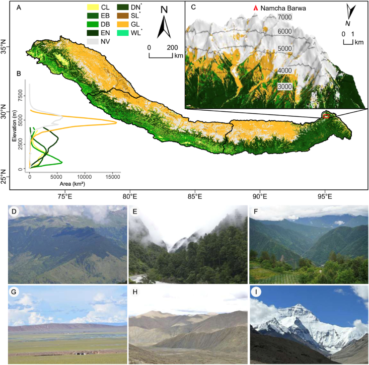
Mountains serve as exceptional natural laboratories for studying biodiversity due to their heterogeneous landforms and climatic zones. The Himalaya, a global biodiversity hotspot, hosts rich endemic flora, supports vital ecosystem functions, and offers a unique window into multifaceted plant diversity patterns. This review synthesizes research on Himalayan plant diversity, including species, phylogenetic, functional, and genetic dimensions, highlighting knowledge gaps and solutions. Research on Himalayan plant diversity has developed significantly. However, gaps remain, especially in studies on phylogenetic and functional diversity. The region's vegetation ranges from tropical rainforests to alpine ecosystems, with species richness typically following a hump-shaped distribution along elevation gradients. The eastern Himalaya exhibits higher plant diversity than the central and western regions. Low-elevation communities were found to be more functionally diverse, whereas high-elevation communities displayed greater ecological specialization. Communities at mid-elevations tend to show greater phylogenetic diversity than those at higher and lower elevations. The eastern and western flanks of the Himalaya retain high levels of genetic diversity and serve as glacial refugia, whereas the central region acts as a hybrid zone for closely related species. Himalayan plant diversity is shaped by historical, climatic, ecological and anthropogenic factors across space and time. However, this rich biodiversity is increasingly threatened by environmental change and growing anthropogenic pressures. Unfortunately, research efforts are constrained by spatial biases and the lack of transnational initiatives and collaborative studies, which could significantly benefit from interdisciplinary approaches, and other coordinated actions. These efforts are vital to safeguarding the Himalayan natural heritage.

Keywords: Biodiversity hotspot; Elevational gradients; Functional diversity; Genetic diversity; Himalaya; Phylogenetic diversity.


Conflict of interest statement

The authors declare no competing interests.

Figures

Image 1
Graphical abstract
Fig. 1
Fig. 1
Geographical, geological, and environmental characteristics of the Himalaya. A, C) Topographical map of the Himalaya, divided into Western, Central, and Eastern Himalaya according to Liu et al. (2022) and Wambulwa et al. (2021). Green mountain labels indicate the highest mountain peaks of each sub-region (Nanga Parbat, Qomolangma, and Kangchenjunga, going from west to east). The three red dashed lines depict the profile position (corresponding to those in the upper line charts of A). The left-lower corner inset indicates the global location of the Himalaya. The upper line charts (A) depict the total land areas along elevations (100 m interval) and the elevation change of longitudinal profiles of three peaks in the Western, Central, and Eastern Himalaya. B) The geological divisions of the Himalaya, arranged from south to north, comprise the Siwalik (Outer) Himalaya, Lesser (Middle) Himalaya, Greater (Higher) Himalaya, and Tethys Himalaya. The Trans-Himalaya, situated north of the Himalaya, is not shown here. This map is inspired from Searle and Treloar (2019) and Mukherjee (2015). D) The two upper maps show the annual mean temperature (AMT) and mean annual precipitation (AP) across the Himalaya; the climatic data were downloaded from WorldClim2 (Fick and Hijmans, 2017). The lower map display the land cover of the Himalaya, and the pie chart shows the relative proportion of each land cover type. [For A and C, we used 30 m resolution elevation data from the Terra Advanced Spaceborne Thermal Emission and Reflection Radiometer (ASTER) and Global Digital Elevation Model (GDEM) Version 3, while D is based on the landcover data from Jung et al. (2020). We employed the R package terra (Hijmans and Bivand, 2022) to calculate the area changes for six categories of vegetation and one category of non-vegetation surface cover at 100 m elevational intervals. The resulting line in A and pie chart of D were generated using the R package ggplot2].
Fig. 2
Fig. 2
Major vegetation types distributed across the Himalaya. A) Horizontal distribution of major vegetation types across the Himalaya. These include cropland (CL), evergreen broadleaved forest (EB), deciduous broadleaved forest (DB), evergreen needle leaved forest (EN), deciduous needle leaved forest (DN), shrub land (SL), grassland (GL), wetlands (WL), and non-vegetation (NV). Vegetation types marked with an asterisk (∗) represent areas too small to be displayed in the line chart. B) Vegetation area distribution with elevation. The line chart shows the area occupied by each vegetation type at 100 m elevation intervals. Data were derived from the Global Digital Elevation Model (GDEM) version 3 and 30 m resolution vegetation data from GLC_FCS30 (Zhang et al., 2021). C) Vertical vegetation zonation along elevation on the northern slope of mount Namcha Barwa (7782 m) in the Eastern Himalaya. Contour lines generated using GDEM data are shown at 1000 m interval from 3000 m to 7000 m. The maps and visualizations were created using ArcGIS Pro v.2.9.2 (ESRI, Redlands, CA, USA). D) Landscape views across the Western Himalaya: E) Scenic landscapes of the Central Himalaya; F) Vegetation-rich landscapes of the Eastern Himalaya; and G) Tethyan Himalaya with its distinct grassland vegetation. H) Landscape to the north of Qomolangma (Tethys Himalaya) and I) View of the high-elevation northern slope of Qomolangma. Photo credits: D, Mustaqeem Ahmad; E–I, Jie Liu. All the pictures were taken during the growing season of each landscape.
Fig. 3
Fig. 3
Current research contributions in the Himalaya. A) Relative proportion of each diversity measure. B) Country-wise percentage contribution to diversity studies. C) Temporal trends in plant diversity publications from 1980 to 2024 in the Himalaya. Data source: The analysis is based on an advanced search in the core database of Web of Science, which covers literature from 1900 to 2024. However, relevant articles on the selected diversity topics were only available starting from 1980 onwards. Consequently, the timespan presented in Fig. 3 is limited to 1980–2024.
Fig. 4
Fig. 4
Species richness map of the Himalaya, along with iconic Himalayan plant species. A) The map illustrates species richness for vascular plant species across the Himalaya, including a breakdown of totals for each region represented in a Venn diagram. The Venn diagram highlights the shared and unique species, genus and family numbers within each region. Color gradients on the map indicate species richness intensity, while grey shaded areas represent regions for which no data was available. The species occurrence data were obtained from four sources: the National Plant Specimen Resource Center of China (NPSRC, https://www.cvh.ac.cn/), the Global Biodiversity Information Facility (GBIF, https://doi.org/10.15468/dl.ffmds4), the Flora of Nepal (FON, https://www.floraofnepal.org/data/mapping), and the India Biodiversity Portal (IBP, https://indiabiodiversity.org/). These data were accessed on January 15th, 2025, without extensive filtering. Figs. B to K represent some iconic Himalayan plant species. B) Rheum tibeticum, C) Rheum nobile, D) Saussureatridactyla, E) Cassiope fastigiata, F) Gentiana vernayi, G) Urtica hperborea, H) Meconopsis horridula, I) Eriophyton wallichii, J) Roscoea tumjensis, K) Taxus contorta. Photo credits: B–K by Jie Liu, except F by Debabrata Maity.
Fig. 5
Fig. 5
Schematic illustration of plant diversity patterns along elevational gradients in the Himalaya. A) Illustrates a hump-shaped pattern of species richness along elevational gradients, B) Depicts a similar hump-shaped pattern of phylogenetic diversity, with mid-elevations harboring the greatest evolutionary diversity driven by overlapping lineages and optimal ecological conditions and, C) Shows a declining trend of functional diversity with increasing elevation. The broader part of the shaded triangular area of functional diversity indicates functional divergence (i.e., greater functional diversity), the narrower part represents functional convergence (i.e., lower functional diversity) in plant functional traits. Notably, these patterns may not apply uniformly to all plant groups or mountain regions.
Fig. 6
Fig. 6
Schematic illustration summarizing the variations in plant organ functional traits (e.g., leaf and flower traits) along environmental gradients (biotic and abiotic) in the Himalaya. At high elevations, plants face significant abiotic stress due to harsh environmental conditions, and reduced plant–plant competition. These factors drive habitat or environmental filtering, leading to trait convergence. In contrast, low elevations, characterized by a warmer climate, diverse climatic gradients, abundant resources, and intense species competition, promote trait divergence (and broader trait distributions), thereby facilitating functional niche partitioning. Notably, these patterns may not be consistent across all plant groups or mountain systems.

References

    1. Ahmad M. Panjab University; Chandigarh, India: 2022. Species Composition and Floral Trait Diversity along an Altitudinal Gradient in the Western Himalaya.https://hdl.handle.net/10603/373396 Ph.D. thesis.
    1. Ahmad M., Uniyal S.K., Batish D.R., et al. Patterns of plant communities along vertical gradient in Dhauladhar mountains in Lesser Himalaya in North-Western India. Sci. Total Environ. 2020;716 doi: 10.1016/j.scitotenv.2020.136919. - DOI - PubMed
    1. Ahmad M., Uniyal S.K., Batish D.R., et al. Flower phenological events and duration pattern is influenced by temperature and elevation in Dhauladhar mountain range of Lesser Himalaya. Ecol. Indic. 2021;129 doi: 10.1016/j.ecolind.2021.107902. - DOI
    1. Ahmad M., Rosbakh S., Bucher S.F., et al. The role of floral traits in community assembly processes at high elevations in the Himalaya. J. Ecol. 2023;111:1107–1119.
    1. Ahmad M., Uniyal S.K., Sharma P., et al. Enhanced plasticity and reproductive fitness of floral and seed traits facilitate non-native species spread in mountain ecosystems. J. Environ. Manag. 2023;348 doi: 10.1016/j.jenvman.2023.119222. - DOI - PubMed

LinkOut - more resources