Using PLUS-InVEST-OPGD model to explore spatiotemporal variation of ecosystem carbon storage and its drivers in Jinsha river basin, China
- PMID: 40746618
- PMCID: PMC12312689
- DOI: 10.7717/peerj.19681
Using PLUS-InVEST-OPGD model to explore spatiotemporal variation of ecosystem carbon storage and its drivers in Jinsha river basin, China
Abstract
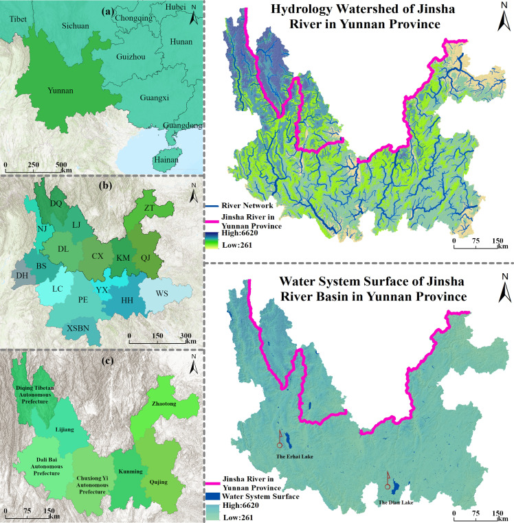
Land-Use/Land-Cover Change (LUCC) is a key disturbance factor of the carbon cycle in terrestrial ecosystems, and the study on the coupling mechanism between LUCC and carbon storage is of great scientific value for implementing a regional carbon-neutral strategy. In this study, the Jinsha River Basin in Yunnan Province, which has outstanding ecological vulnerability, is taken as the research object, and a synergistic analytical framework of "spatial and temporal pattern drivers" is constructed by integrating multi-temporal remote sensing data and multi-model coupling method. Based on the high-precision 30 m land use data from 1990 to 2020, the PLUS-InVEST-OPGD multi-model coupled system was used to simulate and predict the characteristics of spatial and temporal carbon storage differentiation in 2030 under four development scenarios, namely, natural development (ND), ecological protection (EP), farmland protection (FP), and economic development (ED), and to analyze the driving mechanism using the Optimal Parameter Geodetic Probe (OPGP). The driving mechanism is analyzed using an optimal parameter geodetector. The main findings were: (1) The land use structure of the watershed in the study area showed a significant ecological-productive dichotomy, with forest land (60.58%), grassland (28.85%) and cultivated land (7.19%) constituting the core carbon sink carriers (the average proportion of which was 96.62% from 1990 to 2020). Still, the area of forest and grassland decreased by a total of 2,757.84 km2 in the past 30 years, and the expansion of construction land amounted to 2,321.91 km2; (2) the spatial and temporal evolution of carbon storage shows the heterogeneous characteristics of "overall decreasing and local optimization", in which the carbon loss from forest to grassland conversion is as high as 30% of the total carbon loss, and the expansion of construction land leads to irreversible decay of carbon sinks of about 50%; (3) a multi-scenario simulation shows that the EP scenario minimizes the loss of carbon storage (-2.46 × 10⁶ t) by maintaining a 96.82% ecological land share in 2030, reducing the carbon deficit by 7.79 × 10⁶ t compared with the ND scenario; (4) the average annual temperature is the largest single factor affecting carbon storage, and its interaction with the population factor has a high q value of 0.84. This study innovatively reveals the nonlinear threshold effect of LUCC-carbon storage response in the Jinsha River Basin of Yunnan Province, and the proposed optimization model of "ecological protection" can provide decision support and corresponding reference for the construction of ecological security barriers in the upper reaches of the Yangtze River.
Keywords: Carbon storage; Driving mechanism; Future scenario simulation; Jinsha River Basin in Yunnan Province; Land Use and Cover Change (LUCC); Multi-scenario simulation; PLUS-InVEST model.
©2025 Huang et al.
Conflict of interest statement
The authors declare there are no competing interests.
Figures


Similar articles
-
[Spatial-temporal Evolution and Prediction of Carbon Reserves in Wanjiang River Basin with the InVEST-PLUS Model].Huan Jing Ke Xue. 2025 Jun 8;46(6):3818-3829. doi: 10.13227/j.hjkx.202406063. Huan Jing Ke Xue. 2025. PMID: 40582817 Chinese.
-
The impact of the Grain-for-Green Programme on carbon storage in the Upper Yangtze River Basin based on the PLUS-InVEST model.Carbon Balance Manag. 2025 Jul 30;20(1):24. doi: 10.1186/s13021-025-00315-2. Carbon Balance Manag. 2025. PMID: 40739445 Free PMC article.
-
[Exploring the Impact of Future Multi-scenario Land Use Change on Henan Province Regional Carbon Storage].Huan Jing Ke Xue. 2025 Jun 8;46(6):3830-3845. doi: 10.13227/j.hjkx.202405168. Huan Jing Ke Xue. 2025. PMID: 40582818 Chinese.
-
A rapid and systematic review of the clinical effectiveness and cost-effectiveness of paclitaxel, docetaxel, gemcitabine and vinorelbine in non-small-cell lung cancer.Health Technol Assess. 2001;5(32):1-195. doi: 10.3310/hta5320. Health Technol Assess. 2001. PMID: 12065068
-
Cost-effectiveness of using prognostic information to select women with breast cancer for adjuvant systemic therapy.Health Technol Assess. 2006 Sep;10(34):iii-iv, ix-xi, 1-204. doi: 10.3310/hta10340. Health Technol Assess. 2006. PMID: 16959170
References
-
- Al Kafy A, Saha M, Fattah MA, Rahman MT, Duti BM, Rahaman ZA, Bakshi A, Kalaivani S, Rahaman SN, Sattar GS. Integrating forest cover change and carbon storage dynamics: leveraging Google Earth Engine and InVEST model to inform conservation in hilly regions. Ecological Indicators. 2023;152:110374. doi: 10.1016/j.ecolind.2023.110374. - DOI
-
- Arunyawat S, Shrestha RP. Assessing land use change and its impact on ecosystem services in Northern Thailand. Sustainability. 2016;8(8):768. doi: 10.3390/su8080768. - DOI
-
- Chen L, Liu G, Li H. Estimating net primary productivity of terrestrialvegetation in china using remote sensing. Remote Sensing. 2002;6(02):129–135, 164.
MeSH terms
Substances
LinkOut - more resources
Full Text Sources
Miscellaneous