

Prevalence, associated risk factors and satellite imagery analysis in predicting soil-transmitted helminth infection in Nakhon Si Thammarat Province, Thailand
- PMID: 40760156
- PMCID: PMC12322257
- DOI: 10.1038/s41598-025-14221-7
Prevalence, associated risk factors and satellite imagery analysis in predicting soil-transmitted helminth infection in Nakhon Si Thammarat Province, Thailand
Abstract
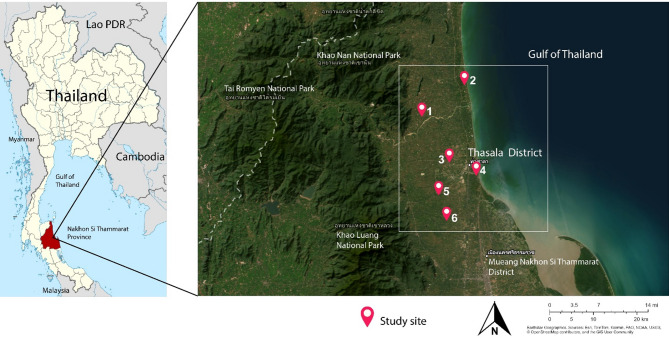
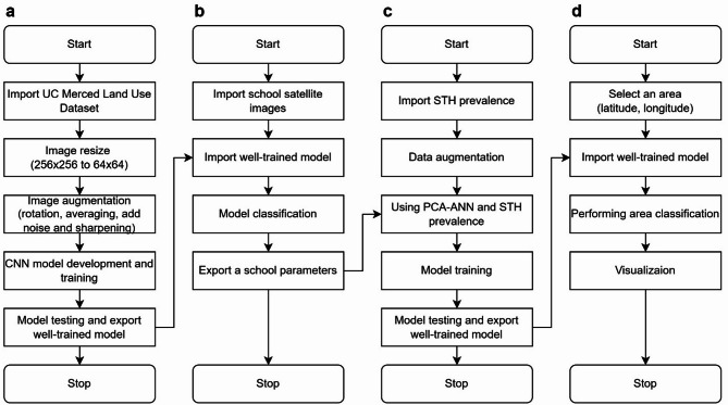
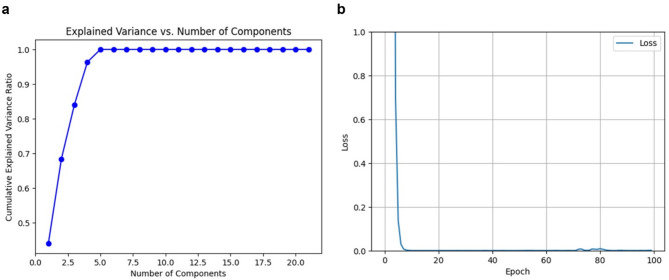
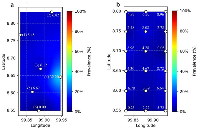
Soil-transmitted helminth (STH) infections remain a significant public health concern in rural areas, often leading to nutritional and physical impairment, particularly in children. This study aimed to assess the prevalence and associated factors of STH infections among schoolchildren in Thasala District, Nakhon Si Thammarat Province, Thailand, and to develop a predictive model for identifying high-risk areas using satellite imagery data. A cross-sectional study was conducted with 319 primary schoolchildren from six sub-districts in Thasala District. Stool samples were analyzed for STH infections using the formalin ethyl acetate concentration technique (FECT) and agar plate culture (APC), while behavioral data were collected through questionnaires to identify key risk factors. We developed an innovative predictive model by integrating convolutional neural networks (CNNs) for land-use classification of satellite imagery with artificial neural networks (ANNs) following dimensionality reduction through principal component analysis (PCA). The STH infections were detected in 31 samples (9.72%), with higher prevalence in males (11.38%) than females (8.67%). Mono-infections predominated, with Trichuris trichiura (5.02%) and hookworm (3.49%) being the most frequent. Mixed infections accounted for 1.25%, primarily co-infections of hookworm with T. trichiura (0.94%) or Strongyloides stercoralis (0.31%). Not cutting nails was identified as a significant behavioral factor associated with STH infections (p = 0.047), while other behavioral factors showed no statistical significance. From the satellite imagery analysis, specific environmental features, particularly higher proportions of agricultural land and closer proximity to water bodies, were positively associated with elevated STH prevalence. The modelling approach generated spatial risk maps for STH infections, providing a cost-effective tool for identifying high-risk transmission zones. These findings highlight that STH infections persist among rural Thai schoolchildren, with poor hygiene practices as a contributing factor. Strengthening hygiene education, improving sanitation, and implementing targeted environmental interventions are essential for effective control.
Keywords: Predictive modeling; Prevalence; Risk factor; Satellite imagery analysis; Soil-transmitted helminth; Thailand.
© 2025. The Author(s).
Conflict of interest statement
Declarations. Competing interests: The authors declare no competing interests.
Figures
Similar articles
-
Prevalence and risk factors of soil-transmitted helminths in humans and domestic animals in southern Côte d'Ivoire.BMC Infect Dis. 2025 Aug 5;25(1):983. doi: 10.1186/s12879-025-11099-8. BMC Infect Dis. 2025. PMID: 40764530 Free PMC article.
-
Soil-Transmitted Helminth Infections and Associated Risk Factors Among Primary Schoolchildren in the Koh Yao Islands of Southern Thailand.J Trop Med. 2025 Jul 24;2025:2907585. doi: 10.1155/jotm/2907585. eCollection 2025. J Trop Med. 2025. PMID: 40746392 Free PMC article.
-
Identifying risk factors for soil-transmitted helminths among indigenous communities in Simalungun, North Sumatra.Trop Biomed. 2025 Jun 1;42(2):85-89. doi: 10.47665/tb.42.2.001. Trop Biomed. 2025. PMID: 40618354
-
Interventions to improve water, sanitation, and hygiene for preventing soil-transmitted helminth infection.Cochrane Database Syst Rev. 2022 Jun 21;6(6):CD012199. doi: 10.1002/14651858.CD012199.pub2. Cochrane Database Syst Rev. 2022. PMID: 35726112 Free PMC article.
-
Water, sanitation, hygiene, and soil-transmitted helminth infection: a systematic review and meta-analysis.PLoS Med. 2014 Mar 25;11(3):e1001620. doi: 10.1371/journal.pmed.1001620. eCollection 2014 Mar. PLoS Med. 2014. PMID: 24667810 Free PMC article.
References
-
- World Health Organization. Soil-transmitted helminth infections (2023). https://www.who.int/news-room/fact-sheets/detail/soil-transmitted-helmin... Accessed 14 Mar 2024.
MeSH terms
Substances
LinkOut - more resources
Full Text Sources
