

An AI-based gravitrap surveillance for spatial interaction analysis in predicting aedes risk
- PMID: 40770655
- PMCID: PMC12329899
- DOI: 10.1186/s12942-025-00403-z
An AI-based gravitrap surveillance for spatial interaction analysis in predicting aedes risk
Abstract
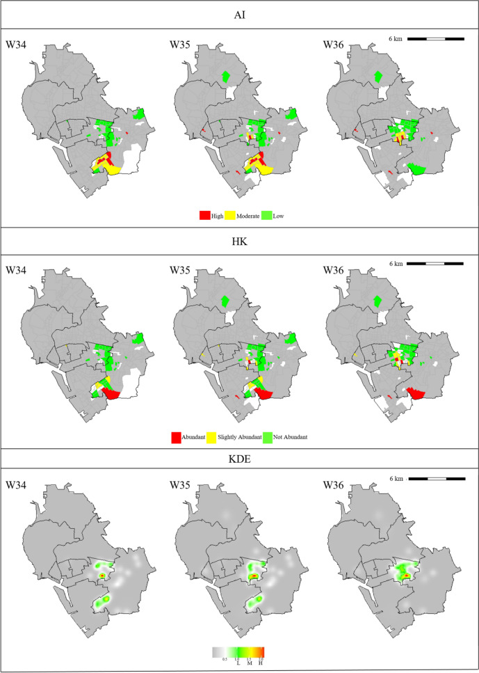
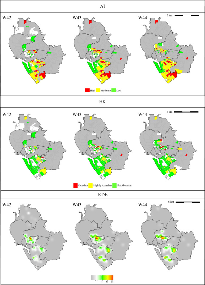
Background: Dengue fever is transmitted to humans through bites of Aedes mosquito vectors. Therefore, controlling the Aedes population can decrease the incidence and block transmission of dengue fever and other diseases transmitted by these mosquito species. In many countries, gravitraps are used to monitor mosquito vector densities, but this approach usually underestimates the population of Aedes mosquitoes. Moreover, literature on the spatio-temporal dynamics of Aedes populations in a single city is limited. For example, in Kaohsiung of Taiwan, population densities vary substantially between villages, and the city government has relatively limited resources to deploy gravitraps. Therefore, a well-defined index should be developed to reflect the spatial-temporal dynamics of adult Aedes mosquitoes in urban environments. This would allow reduction of sources and removal of vector habitats under various situations.
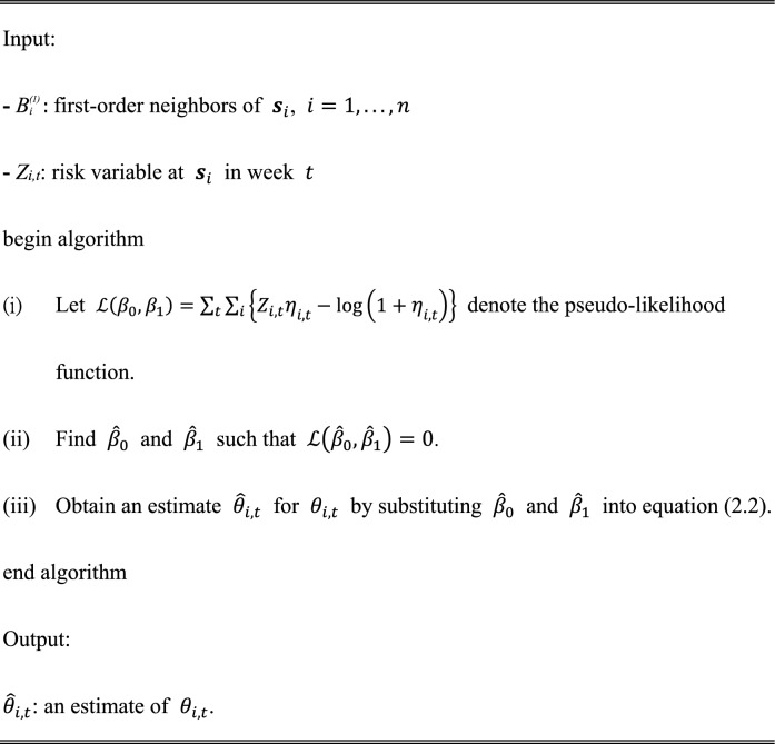
Methods: An artificial intelligence (AI) surveillance based on an auto-Markov model with a non-parametric permutation test is proposed. The auto-Markov model takes neighborhood effects into consideration, and can therefore adjust spatial-temporal risks dynamically in various seasons and environmental background. Information from neighboring villages is incorporated into the model to enhance precision of risk prediction.
Results: The proposed AI gravitrap index integrates the auto-Markov and disease mapping models to enhance sensitivity in risk prediction for Aedes densities. Simulation studies and cross-validation analysis indicated that the AI index could be more efficient than traditional indices in assessing risk levels. This means that using the AI index could also reduce allocation cost for gravitraps. Moreover, since the auto-Markov model accommodates spatial-temporal dependence, a risk map by the AI index could reflect spatial-temporal dynamics for Aedes densities more accurate.
Conclusions: The AI gravitrap index can dynamically update risk levels by the auto-Markov model with an unsupervised permutation test. The proposed index thus has flexibility to apply in various cities with different environmental background and weather conditions. Furthermore, a risk map by the AI index could provide guidance for policymakers to prevent dengue epidemics.
Keywords: Aedes index; AI method; Auto-Markov model; Dengue prevention; Gravitrap; Spatial–temporal patterns.
© 2025. The Author(s).
Conflict of interest statement
Declarations. Ethics approval and consent to participate: Not applicable. Competing interests: The authors declare no competing interests.
Figures


References
-
- Jaffal A, Fite J, Baldet T, Delaunay P, Jourdain F, Mora-Castillo R, et al. Current evidences of the efficacy of mosquito mass-trapping interventions to reduce Aedes aegypti and Aedes albopictus populations and Aedes-borne virus transmission. PLoS Negl Trop Dis. 2023;17:e0011153. 10.1371/journal.pntd.0011153. - PMC - PubMed
-
- Chadee DD. Dengue cases and Aedes aegypti indices in Trinidad, West Indies. Acta Trop. 2009;112:174–80. 10.1016/j.actatropica.2009.07.017. - PubMed
Publication types
MeSH terms
Grants and funding
LinkOut - more resources
Full Text Sources
Medical
