

Local Ecological Knowledge Insights Into the Distribution and Activity Patterns of Temminck's Pangolin in Ruaha Landscape, Tanzania
- PMID: 40823046
- PMCID: PMC12357171
- DOI: 10.1002/ece3.71987
Local Ecological Knowledge Insights Into the Distribution and Activity Patterns of Temminck's Pangolin in Ruaha Landscape, Tanzania
Abstract
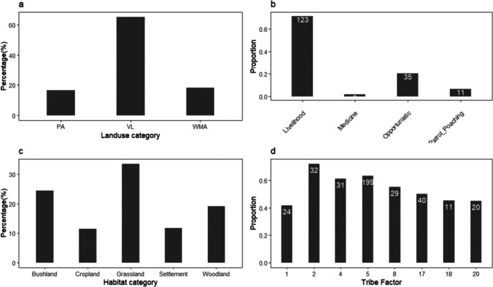
Tanzania is home to three species of pangolins: Temminck's pangolin (Smutsia temminckii), giant ground pangolin (Smutsia gigantea), and white-bellied pangolin (Phataginus tricuspis). However, distribution and habitat preferences have yet to be well known across the Ruaha landscape, encompassing the core of Ruaha National Park and adjacent protected and unprotected village lands. This area is thought to hold Temminck's pangolin. Drawing upon local knowledge to help inform conservation planning, we used semi-structured interviews among village members to investigate the distribution and activity pattern of Temminck's pangolins in the Ruaha landscape. Our results show that village lands hold potential habitats for pangolins, and unsurprisingly, that human land use by activity type and human behavior itself influences pangolin observations across the landscape, more so than pangolin ecology. We also learned that more than half of our study's participants did not perceive a decreasing population trend in pangolins over 5 years, despite reports from authorities. Our study provides novel and important baseline information about the distribution of pangolins in the Ruaha landscape, which can be used for spatially relevant conservation planning at local and national scales. Given their willingness to share local knowledge about pangolins and participate in pangolin conservation, we suggest that village members be actively engaged in pangolin conservation efforts, including training on monitoring and reporting pangolin population and distribution, and assisting in habitat management.
Keywords: Tanzania; community; conservation; distribution; local knowledge; planning.
© 2025 The Author(s). Ecology and Evolution published by British Ecological Society and John Wiley & Sons Ltd.
Conflict of interest statement
The authors declare no conflicts of interest.
Figures


References
-
- Abu‐Bakarr, I. , Bakarr M. I., Gelman N., et al. 2022. “Capacity and Leadership Development for Wildlife Conservation in Sub‐Saharan Africa: Assessment of a Programme Linking Training and Mentorship.” Oryx 56, no. 5: 744–752. 10.1017/S0030605321000855. - DOI
-
- Aditya, V. , Komanduri K. P., Subhedar R., and Ganesh T.. 2021. “Integrating Camera Traps and Community Knowledge to Assess the Status of the Indian Pangolin Manis crassicaudata in the Eastern Ghats, India.” Oryx 55, no. 5: 677–683. 10.1017/S0030605319001303. - DOI
-
- Baiyewu, A. O. , Boakye M. K., Kotzé A., Dalton D. L., and Jansen R.. 2018. “Ethnozoological Survey of Traditional Uses of Temminck's Ground Pangolin (Smutsia temminckii) in South Africa.” Society and Animals 26, no. 3: 306–307. 10.1163/15685306-12341515. - DOI
LinkOut - more resources
Full Text Sources
