

Channelized metasomatism in Archean cratonic roots as a mechanism of lithospheric refertilization
- PMID: 40825945
- PMCID: PMC12361372
- DOI: 10.1038/s41467-025-62912-6
Channelized metasomatism in Archean cratonic roots as a mechanism of lithospheric refertilization
Abstract
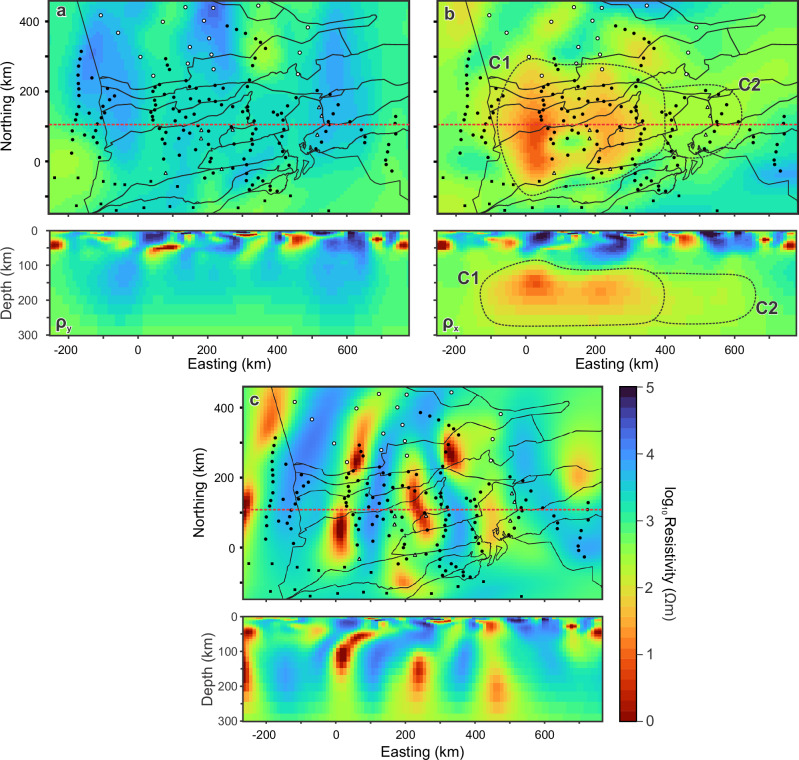
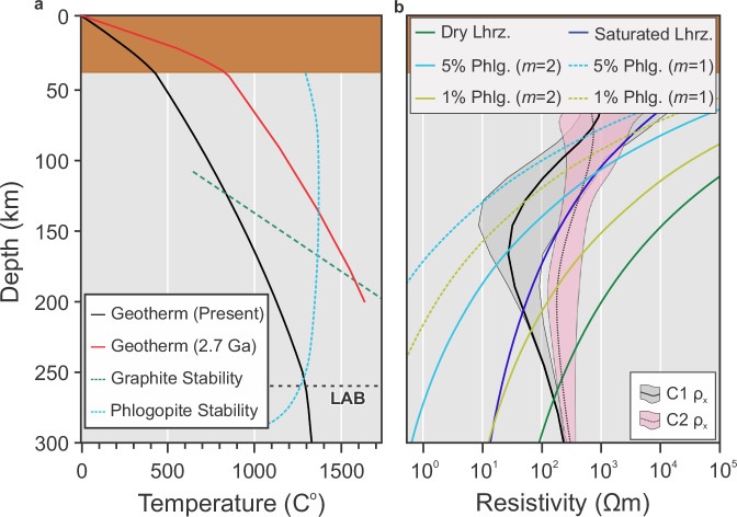
Archean cratons represent stable continental domains which form the nuclei of the Earth's continents due to their thick ( >200 km), mechanically resistant keels. Cratons and their stable roots form through melt and fluid depletion processes. However, metasomatic refertilization may occur due to processes coeval with craton construction and/or overprinting episodes. Magnetotellurics, a geophysical method measuring subsurface electrical resistivity, is sensitive to the compositional and thermal states of the lithosphere and is useful in mapping depleted and refertilized cratonic domains. Here we show the results of a 3D anisotropic inversion to image the lithospheric resistivity structure of the western Superior Craton. The resistivity model reveals widespread (500×300 km2) anisotropy with a north-south conductive axis at depths ~100-200 km, inferred to represent phlogopite-bearing channels emplaced during mantle plume activity. The results have implications for our understanding of the modification and long-term stability of cratonic lithosphere, and the imaging and interpretation of their preserved geophysical signatures.
© 2025. The Author(s).
Conflict of interest statement
Competing interests: The authors declare no competing interests.
Figures


References
-
- Sleep, N. H., Ebinger, C. J. & Kendall, J. M. Deflection of mantle plume material by cratonic keels. Geol. Soc. Spec. Publ.199, 135–150 (2002).
-
- Frieman, B. M. et al. Insight into Archean crustal growth and mantle evolution from multi-isotope U-Pb and Lu-Hf analysis of detrital zircon grains from the Abitibi and Pontiac subprovinces, Canada. Precambrian Res.357, 106136 (2021).
-
- Hoffman, P. F. United Plates of America, the birth of a craton: early Proterozoic assembly and growth of Laurentia. Annu. Rev. Earth Planet. Sci.16, 543–603 (1988).
-
- Selway, K. On the causes of electrical conductivity anomalies in tectonically stable lithosphere. Surv. Geophys.35, 219–257 (2014).
-
- Liu, L. et al. Development of a dense cratonic keel prior to the destruction of the North China Craton: constraints from sedimentary records and numerical simulation. J. Geophys. Res. Solid Earth124, 13192–13206 (2019).
Grants and funding
LinkOut - more resources
Full Text Sources
