. 1998 Dec 8;95(25):14839-42.
doi: 10.1073/pnas.95.25.14839.

Drought-induced shift of a forest-woodland ecotone: rapid landscape response to climate variation

Affiliations

Drought-induced shift of a forest-woodland ecotone: rapid landscape response to climate variation

C D Allen et al. Proc Natl Acad Sci U S A. .

Abstract

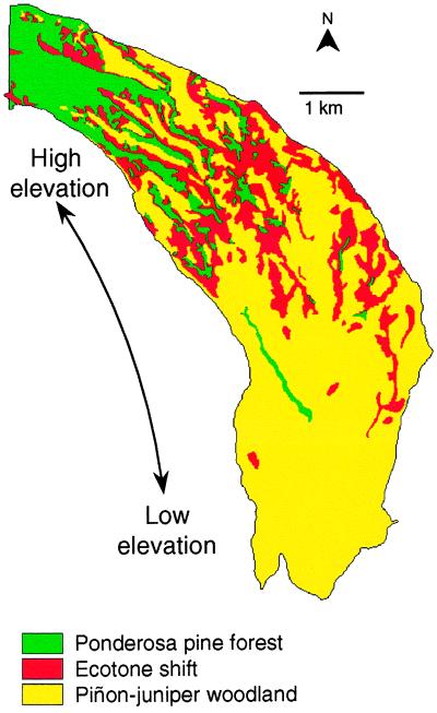
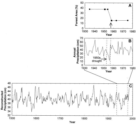
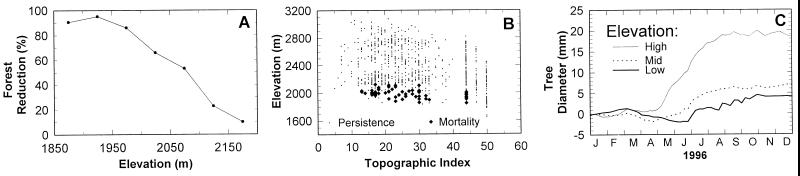
In coming decades, global climate changes are expected to produce large shifts in vegetation distributions at unprecedented rates. These shifts are expected to be most rapid and extreme at ecotones, the boundaries between ecosystems, particularly those in semiarid landscapes. However, current models do not adequately provide for such rapid effects-particularly those caused by mortality-largely because of the lack of data from field studies. Here we report the most rapid landscape-scale shift of a woody ecotone ever documented: in northern New Mexico in the 1950s, the ecotone between semiarid ponderosa pine forest and pinon-juniper woodland shifted extensively (2 km or more) and rapidly (<5 years) through mortality of ponderosa pines in response to a severe drought. This shift has persisted for 40 years. Forest patches within the shift zone became much more fragmented, and soil erosion greatly accelerated. The rapidity and the complex dynamics of the persistent shift point to the need to represent more accurately these dynamics, especially the mortality factor, in assessments of the effects of climate change.


Figures

Figure 1
Figure 1
Changes in vegetation cover between 1954 and 1963 in the study area, showing persistent ponderosa pine forest (365 ha), persistent piñon–juniper woodland (1527 ha), and the ecotone shift zone (486 ha) where forest changed to woodland.
Figure 2
Figure 2
(A) Changes in percent forest area between 1935 and 1975. Circles represent GIS estimates derived from mapped data; squares represent estimates for years with only partial aerial photograph coverage. The arrow indicates the time of historical observations of extensive tree mortality (22). (B) Annual precipitation at Bandelier National Monument, 1930–1980, highlighting the period of extreme drought (dashed vertical lies). (C) Annual precipitation (5-yr running average), reconstructed from dendrochronological records for the Jemez Mountains, encompassing the study site (Unpublished data from J. S. Dean and G. S. Funkhouser, personal communication). The magnitude of the 1950s drought (within the dashed vertical lines) was exceeded only by the drought of the late 1500s. Other precipitation reconstructions in the region show similar patterns (–25).
Figure 3
Figure 3
(A) Forest reduction between 1954 and 1963, estimated from GIS analyses. Forest reduction was greatest at lower elevations. (B) Field observations of the persistence () and mortality (⧫) of ponderosa pines, determined from remains of dead trees as a function of elevation and topographic position. Topographic position indices ranged from small values for exposed ridgetops to large values for sheltered valley bottoms (22, 26). Across most topographic positions, mortality was greatest at lower elevations. (C) Mean changes in stem diameter during calendar year 1996 for ponderosa pine along an elevation/moisture gradient (10 trees were measured at each of three sites: 2,010 m elevation (bold line) with 41 cm/year precipitation; 2,320 m (dashed line) with 51 cm/year; 2,780 m (thin line) with 89 cm/year). Annual stem diameter increment (tree growth) was greater at the mesic, high-elevation site than at the xeric, low-elevation site. In addition, at the end of a dry winter/spring period in 1995–1996, stem diameter actually decreased because of water stress at the low-elevation site between April and mid-June, normally the time of most rapid growth.

References

    1. Betancourt J L, Van Devender T R, editors. Packrat Middens: The Last 40,000 Years of Biotic Change. Tucson, AZ: Univ. of Arizona Press; 1990. - PubMed
    1. Gosz J R. Ecol Appl. 1992;2:248–261. - PubMed
    1. Risser P G. Bioscience. 1995;45:318–325.
    1. Pitelka L F the Plant Migration Workshop Group. Am Sci. 1997;85:464–473.
    1. Holland M M, Risser P G, Naiman R J, editors. Ecotones: The Role of Landscape Boundaries in the Management and Restoration of Changing Environments. New York: Chapman & Hall; 1991.

LinkOut - more resources